 Republic of Panama Google Maps and Facts
Welcome to the Google Maps of Panama (PA) and the comprehensive location list for this country. World Route Planner, together with its detailed Panama page, turns Google Maps Sightseeing into a meaningful experience! Our extensive destination gazetteer, coupled with Driving Directions to Panama, allows you to explore Panama through detailed satellite imagery and street views—fast, free, and easier than ever before.
Browse through the list of administrative regions in Panama, navigate through these regions to find a place of interest, and book your hotel with the Best Price Guarantee! Your journey through Panama via Google Satellite Map Sightseeing and Street View starts here.
Panama Google Maps
To activate Street View on any city of Panama, drag above the Zoom feature the yellow little man in the map.
Facts about Panama
| Administrative divisions: | 11 provinces (provincias , singular - provincia) and 1 territory* (comarca); Bocas del Toro , Comarca Kuna Yala , Comarca Ngobe-Bugle , Chiriqui , Cocle , Colon , Darien , Herrera , Los Santos , Panama , San Blas*(Kuna Yala) , and Veraguas |
| Area: | total: 78 ,200 sq km land: 75 ,990 sq km water: 2 ,210 sq km |
| Background: | Explored and settled by the Spanish in the 16th century , Panama broke with Spain in 1821 and joined a union of Colombia , Ecuador , and Venezuela - named the Republic of Gran Colombia. When the latter dissolved in 1830 , Panama remained part of Colombia. With US backing , Panama seceded from Colombia in 1903 and promptly signed a treaty with the US allowing for the construction of a canal and US sovereignty over a strip of land on either side of the structure (the Panama Canal Zone). The Panama Canal was built by the US Army Corps of Engineers between 1904 and 1914. In 1977 , an agreement was signed for the complete transfer of the Canal from the US to Panama by the end of the century. Certain portions of the Zone and increasing responsibility over the Canal were turned over in the subsequent decades. With US help , dictator Manuel NORIEGA was deposed in 1989. The entire Panama Canal , the area supporting the Canal , and remaining US military bases were transferred to Panama by the end of 1999. In October 2006 , Panamanians approved an ambitious plan to expand the Canal. The project , which began in 2007 and could double the Canal's capacity , is expected to be completed in 2014-15. |
| Flag description: | divided into four , equal rectangles; the top quadrants are white (hoist side) with a blue five-pointed star in the center and plain red; the bottom quadrants are plain blue (hoist side) and white with a red five-pointed star in the center |
| Capital: | name: Panama geographic coordinates: 8 58 N , 79 32 W time difference: UTC-5 (same time as Washington , DC during Standard Time) |
| Climate: | tropical maritime; hot , humid , cloudy; prolonged rainy season (May to January) , short dry season (January to May) |
| Currency code: | balboa (PAB); US dollar (USD) |
| Ethnic groups: | mestizo (mixed Amerindian and white) 70% , Amerindian and mixed (West Indian) 14% , white 10% , Amerindian 6% |
| Geographic coordinates: | 9 00 N , 80 00 W |
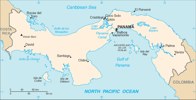
| Geography note: | strategic location on eastern end of isthmus forming land bridge connecting North and South America; controls Panama Canal that links North Atlantic Ocean via Caribbean Sea with North Pacific Ocean |
| Government type: | constitutional democracy |
| Imports partners: | Japan 28.7% , China 18.6% , Singapore 12.8% , US 12.5% (2007) |
| Internet country code: | .pa |
| Land boundaries: | 2 ,490 km |
| Neighbouring countries: | total: 555 km border countries: Colombia 225 km , Costa Rica 330 km |
| Languages: | Spanish (official) , English 14%; note - many Panamanians bilingual |
| Location: | Central America , bordering both the Caribbean Sea and the North Pacific Ocean , between Colombia and Costa Rica |
| Map references: | Central America and the Caribbean |
| National holiday: | Independence Day , 3 November (1903) |
| Nationality: | noun: Panamanian(s) adjective: Panamanian |
| Natural hazards: | occasional severe storms and forest fires in the Darien area |
| Population: | 3 ,309 ,679 (July 2008 est.) |
| Religions: | Roman Catholic 85% , Protestant 15% |
| Terrain: | interior mostly steep , rugged mountains and dissected , upland plains; coastal areas largely plains and rolling hills |
| Unemployment rate: | 6.4% (2007 est.) |
Capital of Republic of Panama
Panamá (click to view Panamá map)
Places in Panama
Browse the most comprehensive and up-to-date online directory of administrative regions and Street Views in Panama. Our listings are organized alphabetically, starting from level 1 regions and progressing through to level 2 and eventually level 3 regions, ensuring you can easily navigate and find specific areas of interest.
Chiriquí Province (768 google map locations)
Coclé Province (606 google map locations)
Colón Province (336 google map locations)
Darién Province (142 google map locations)
Kuna Yala Indigenous Region (89 google map locations)
Los Santos Province (593 google map locations)
Panamá Province (829 google map locations)
Veraguas Province (1101 google map locations)
Random cities in Panama
Panamá, the capital city of Panama.Tolé
Los Picadores
Ciricito Los Sotos
Guayacán
Alto del Mora
Pie de Cerro Banco
Loma de Eligio
Zapotal de Espalá
Palo Blanco
Mojarras
Cerro Caballo
Cerro Las Vacas
Nuestro Amo
El Jagua Número Uno
Batipa
La Miel
Dos Ríos Abajo
Dominical
El Mostrenco
Link to Panama Google Maps page
The map of Panama has already attracted 5509 views. If you wish to embed our comprehensive Panama map on your site, we offer an easy solution. This map includes free access to Google Maps, gazetteer search, detailed country and city maps, Street View, and essential facts, all ready to enhance your website. To use it, simply copy and paste the provided HTML code into your webpage's source code. We appreciate every link back to our Maps and Driving Directions. Thank you for your support!
| Text link to: Panama map and facts page |
This Panama map is intended solely for informational purposes. No representations or warranties are made concerning its accuracy or reliability. Users assume all risks associated with the use of Google Maps and Google Driving Directions. World Route Planner is not liable for any losses or delays that may occur from using this free Panama map.