 Turks and Caicos Islands Google Maps and Facts
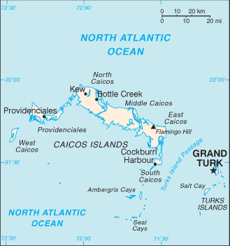
Map of Turks and Caicos Islands ⇣ | Google Maps of Turks and Caicos Islands ⇣ | All Places in Turks and Caicos Islands ⇣
Welcome to the Google Maps of Turks and Caicos Islands (TC) and the comprehensive location list for this country. World Route Planner, together with its detailed Turks and Caicos Islands page, turns Google Maps Sightseeing into a meaningful experience! Our extensive destination gazetteer, coupled with Driving Directions to Turks and Caicos Islands, allows you to explore Turks and Caicos Islands through detailed satellite imagery and street views—fast, free, and easier than ever before.
Browse through the list of administrative regions in Turks and Caicos Islands, navigate through these regions to find a place of interest, and book your hotel with the Best Price Guarantee! Your journey through Turks and Caicos Islands via Google Satellite Map Sightseeing and Street View starts here.
Turks and Caicos Islands Google Maps
To activate Street View on any city of Turks and Caicos Islands, drag above the Zoom feature the yellow little man in the map.
Facts about Turks and Caicos Islands
| Administrative divisions: | none (overseas territory of the UK) |
| Area: | total: 430 sq km land: 430 sq km water: 0 sq km |
| Background: | The islands were part of the UK's Jamaican colony until 1962 , when they assumed the status of a separate crown colony upon Jamaica's independence. The governor of The Bahamas oversaw affairs from 1965 to 1973. With Bahamian independence , the islands received a separate governor in 1973. Although independence was agreed upon for 1982 , the policy was reversed and the islands remain a British overseas territory. |
| Flag description: | blue , with the flag of the UK in the upper hoist-side quadrant and the colonial shield centered on the outer half of the flag; the shield is yellow and contains a conch shell , lobster , and cactus |
| Capital: | name: Grand Turk (Cockburn Town) geographic coordinates: 21 28 N , 71 08 W time difference: UTC-5 (same time as Washington , DC during Standard Time) daylight saving time: +1hr , begins first Sunday in April; ends last Sunday in October |
| Climate: | tropical; marine; moderated by trade winds; sunny and relatively dry |
| Currency code: | |
| Ethnic groups: | black 90% , mixed , European , or North American 10% |
| Geographic coordinates: | 21 45 N , 71 35 W |
| Geography note: | about 40 islands (eight inhabited) |
| Government type: | NA |
| Imports partners: | US , UK (2006) |
| Internet country code: | .tc |
| Land boundaries: | 389 km |
| Neighbouring countries: | 0 km |
| Languages: | English (official) |
| Location: | Caribbean , two island groups in the North Atlantic Ocean , southeast of The Bahamas , north of Haiti |
| Map references: | Central America and the Caribbean |
| National holiday: | Constitution Day , 30 August (1976) |
| Nationality: | noun: none adjective: none |
| Natural hazards: | frequent hurricanes |
| Population: | 22 ,352 (July 2008 est.) |
| Religions: | Baptist 40% , Anglican 18% , Methodist 16% , Church of God 12% , other 14% (1990) |
| Terrain: | low , flat limestone; extensive marshes and mangrove swamps |
| Unemployment rate: | 10% (1997 est.) |
Capital of Turks and Caicos Islands
Grand Turk (click to view Grand Turk map)
Places in Turks and Caicos Islands
Browse the most comprehensive and up-to-date online directory of administrative regions and Street Views in Turks and Caicos Islands. Our listings are organized alphabetically, starting from level 1 regions and progressing through to level 2 and eventually level 3 regions, ensuring you can easily navigate and find specific areas of interest.
Balfour Town city Google map
Bambarra city Google map
Blue Hills Settlements city Google map
Bottle Creek Settlements city Google map
Cockburn Harbour city Google map
Conch Bar city Google map
Five Cays Settlement city Google map
Grand Turk city Google map
Kew city Google map
Lorimers city Google map
Over Back The Damp city Google map
Sandy Point city Google map
The Bight Settlements city Google map
West Road city Google map
Whitby city Google map
Yankee Town city Google map
Random cities in Turks and Caicos Islands
Grand Turk, the capital city of Turks and Caicos Islands.The Bight Settlements
Conch Bar
Kew
Lorimers
Cockburn Harbour
Whitby
West Road
Balfour Town
Grand Turk
Sandy Point
Greenwich
Bottle Creek Settlements
Back Salina
Bambarra
Five Cays Settlement
Yankee Town
Blue Hills Settlements
Link to Turks and Caicos Islands Google Maps page
The map of Turks and Caicos Islands has already attracted 2654 views. If you wish to embed our comprehensive Turks and Caicos Islands map on your site, we offer an easy solution. This map includes free access to Google Maps, gazetteer search, detailed country and city maps, Street View, and essential facts, all ready to enhance your website. To use it, simply copy and paste the provided HTML code into your webpage's source code. We appreciate every link back to our Maps and Driving Directions. Thank you for your support!
| Text link to: Turks and Caicos Islands map and facts page |
This Turks and Caicos Islands map is intended solely for informational purposes. No representations or warranties are made concerning its accuracy or reliability. Users assume all risks associated with the use of Google Maps and Google Driving Directions. World Route Planner is not liable for any losses or delays that may occur from using this free Turks and Caicos Islands map.