 Republic of Austria Google Maps and Facts
Welcome to the Google Maps of Austria (AT) and the comprehensive location list for this country. World Route Planner, together with its detailed Austria page, turns Google Maps Sightseeing into a meaningful experience! Our extensive destination gazetteer, coupled with Driving Directions to Austria, allows you to explore Austria through detailed satellite imagery and street views—fast, free, and easier than ever before.
Browse through the list of administrative regions in Austria, navigate through these regions to find a place of interest, and book your hotel with the Best Price Guarantee! Your journey through Austria via Google Satellite Map Sightseeing and Street View starts here.
Austria Google Maps
To activate Street View on any city of Austria, drag above the Zoom feature the yellow little man in the map.
Facts about Austria
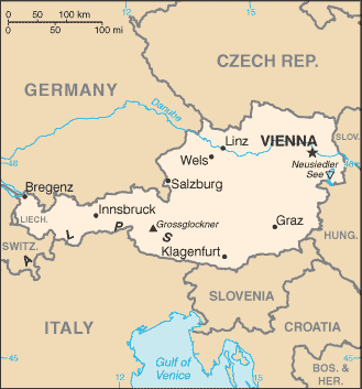
| Administrative divisions: | 9 states (Bundeslaender , singular - Bundesland); Burgenland , Kaernten (Carinthia) , Niederoesterreich (Lower Austria) , Oberoesterreich (Upper Austria) , Salzburg , Steiermark (Styria) , Tirol (Tyrol) , Vorarlberg , Wien (Vienna) |
| Area: | total: 83 ,870 sq km land: 82 ,444 sq km water: 1 ,426 sq km |
| Background: | Once the center of power for the large Austro-Hungarian Empire , Austria was reduced to a small republic after its defeat in World War I. Following annexation by Nazi Germany in 1938 and subsequent occupation by the victorious Allies in 1945 , Austria's status remained unclear for a decade. A State Treaty signed in 1955 ended the occupation , recognized Austria's independence , and forbade unification with Germany. A constitutional law that same year declared the country's "perpetual neutrality" as a condition for Soviet military withdrawal. The Soviet Union's collapse in 1991 and Austria's entry into the European Union in 1995 have altered the meaning of this neutrality. A prosperous , democratic country , Austria entered the EU Economic and Monetary Union in 1999. |
| Flag description: | three equal horizontal bands of red (top) , white , and red |
| Capital: | name: Vienna geographic coordinates: 48 12 N , 16 22 E time difference: UTC+1 (6 hours ahead of Washington , DC during Standard Time) daylight saving time: +1hr , begins last Sunday in March; ends last Sunday in October |
| Climate: | temperate; continental , cloudy; cold winters with frequent rain and some snow in lowlands and snow in mountains; moderate summers with occasional showers |
| Currency code: | euro (EUR) |
| Ethnic groups: | Austrians 91.1% , former Yugoslavs 4% (includes Croatians , Slovenes , Serbs , and Bosniaks) , Turks 1.6% , German 0.9% , other or unspecified 2.4% (2001 census) |
| Geographic coordinates: | 47 20 N , 13 20 E |
| Geography note: | landlocked; strategic location at the crossroads of central Europe with many easily traversable Alpine passes and valleys; major river is the Danube; population is concentrated on eastern lowlands because of steep slopes , poor soils , and low temperatures elsewhere |
| Government type: | federal republic |
| Imports partners: | Germany 45.5% , Italy 7.1% , Switzerland 5% , Netherlands 4.3% (2007) |
| Internet country code: | .at |
| Land boundaries: | 0 km (landlocked) |
| Neighbouring countries: | total: 2 ,562 km border countries: Czech Republic 362 km , Germany 784 km , Hungary 366 km , Italy 430 km , Liechtenstein 35 km , Slovakia 91 km , Slovenia 330 km , Switzerland 164 km |
| Languages: | German (official nationwide) 88.6% , Turkish 2.3% , Serbian 2.2% , Croatian (official in Burgenland) 1.6% , other (includes Slovene , official in Carinthia , and Hungarian , official in Burgenland) 5.3% (2001 census) |
| Location: | Central Europe , north of Italy and Slovenia |
| Map references: | Europe |
| National holiday: | National Day , 26 October (1955); note - commemorates the passage of the law on permanent neutrality |
| Nationality: | noun: Austrian(s) adjective: Austrian |
| Natural hazards: | landslides; avalanches; earthquakes |
| Population: | 8 ,205 ,533 (July 2008 est.) |
| Religions: | Roman Catholic 73.6% , Protestant 4.7% , Muslim 4.2% , other 3.5% , unspecified 2% , none 12% (2001 census) |
| Terrain: | in the west and south mostly mountains (Alps); along the eastern and northern margins mostly flat or gently sloping |
| Unemployment rate: | 4.4% (2007 est.) |
Capital of Republic of Austria
Wien (click to view Wien map)
Places in Austria
Browse the most comprehensive and up-to-date online directory of administrative regions and Street Views in Austria. Our listings are organized alphabetically, starting from level 1 regions and progressing through to level 2 and eventually level 3 regions, ensuring you can easily navigate and find specific areas of interest.
Carinthia (1682 google map locations)
Lower Austria (3273 google map locations)
Salzburg (958 google map locations)
Styria (2858 google map locations)
Upper Austria (2791 google map locations)
Vienna (94 google map locations)
Vorarlberg (383 google map locations)
Random cities in Austria
Wien, the capital city of Austria.Riedern
Ausseraigen
Andiesen
Seedörfl
Goschenreith am Taxenbache
Obersteigenthal
Fürstau
Pötzleinsdorf
Schaidnik
Pichla bei Mureck
Fischering
Dietachdorf
Götzles
Letina
Massweg
Schwarzach
Feldham
Pirk
Waldwinkl
Link to Austria Google Maps page
The map of Austria has already attracted 10778 views. If you wish to embed our comprehensive Austria map on your site, we offer an easy solution. This map includes free access to Google Maps, gazetteer search, detailed country and city maps, Street View, and essential facts, all ready to enhance your website. To use it, simply copy and paste the provided HTML code into your webpage's source code. We appreciate every link back to our Maps and Driving Directions. Thank you for your support!
| Text link to: Austria map and facts page |
This Austria map is intended solely for informational purposes. No representations or warranties are made concerning its accuracy or reliability. Users assume all risks associated with the use of Google Maps and Google Driving Directions. World Route Planner is not liable for any losses or delays that may occur from using this free Austria map.