 Bailiwick of Guernsey Google Maps and Facts
Welcome to the Google Maps of Guernsey (GG) and the comprehensive location list for this country. World Route Planner, together with its detailed Guernsey page, turns Google Maps Sightseeing into a meaningful experience! Our extensive destination gazetteer, coupled with Driving Directions to Guernsey, allows you to explore Guernsey through detailed satellite imagery and street views—fast, free, and easier than ever before.
Browse through the list of administrative regions in Guernsey, navigate through these regions to find a place of interest, and book your hotel with the Best Price Guarantee! Your journey through Guernsey via Google Satellite Map Sightseeing and Street View starts here.
Guernsey Google Maps
To activate Street View on any city of Guernsey, drag above the Zoom feature the yellow little man in the map.
Facts about Guernsey
| Administrative divisions: | none (British crown dependency); there are no first-order administrative divisions as defined by the US Government , but there are 10 parishes including Castel , Forest , Saint Andrew , Saint Martin , Saint Peter Port , Saint Pierre du Bois , Saint Sampson , Saint Saviour , Torteval , Vale |
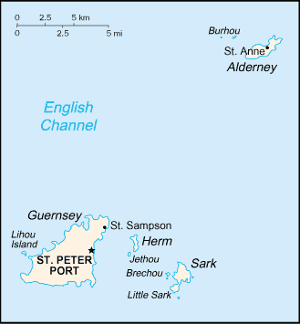
| Area: | total: 78 sq km land: 78 sq km water: 0 sq km note: includes Alderney , Guernsey , Herm , Sark , and some other smaller islands |
| Background: | Guernsey and the other Channel Islands represent the last remnants of the medieval Dukedom of Normandy , which held sway in both France and England. The islands were the only British soil occupied by German troops in World War II. Guernsey is a British crown dependency , but is not part of the UK. However , the UK Government is constitutionally responsible for its defense and international representation. |
| Flag description: | white with the red cross of Saint George (patron saint of England) extending to the edges of the flag and a yellow equal-armed cross of William the Conqueror superimposed on the Saint George cross |
| Capital: | name: Saint Peter Port geographic coordinates: 49 27 N , 2 32 W time difference: UTC 0 (5 hours ahead of Washington , DC during Standard Time) daylight saving time: +1hr , begins last Sunday in March; ends last Sunday in October |
| Climate: | temperate with mild winters and cool summers; about 50% of days are overcast |
| Currency code: | Guernsey pound note: the British pound is also legal tender |
| Ethnic groups: | UK and Norman-French descent with small percentages from other European countries |
| Geographic coordinates: | 49 28 N , 2 35 W |
| Geography note: | large , deepwater harbor at Saint Peter Port |
| Government type: | parliamentary democracy |
| Imports partners: | UK; note - regarded as internal trade (2006) |
| Internet country code: | .gg |
| Land boundaries: | 50 km |
| Neighbouring countries: | 0 km |
| Languages: | English , French , Norman-French dialect spoken in country districts |
| Location: | Western Europe , islands in the English Channel , northwest of France |
| Map references: | Europe |
| National holiday: | Liberation Day , 9 May (1945) |
| Nationality: | noun: Channel Islander(s) adjective: Channel Islander |
| Natural hazards: | NA |
| Population: | 65 ,726 (July 2008 est.) |
| Religions: | Anglican , Roman Catholic , Presbyterian , Baptist , Congregational , Methodist |
| Terrain: | mostly level with low hills in southwest |
| Unemployment rate: | 0.9% (March 2006 est.) |
Capital of Bailiwick of Guernsey
Saint Peter Port (click to view Saint Peter Port map)
Places in Guernsey
Browse the most comprehensive and up-to-date online directory of administrative regions and Street Views in Guernsey. Our listings are organized alphabetically, starting from level 1 regions and progressing through to level 2 and eventually level 3 regions, ensuring you can easily navigate and find specific areas of interest.
Beauregard city Google map
Braye city Google map
Calais city Google map
Fregondée city Google map
Grand Roques city Google map
Hautnez city Google map
Houmet city Google map
Kings Mills city Google map
La Ramée city Google map
La Ville Roussel city Google map
Les Nicolles city Google map
Paradis city Google map
Rohais Manor city Google map
Roque Tourgis city Google map
Saint Anne city Google map
Saint Peter Port city Google map
Saint Sampson city Google map
Saumarez city Google map
St Peter Port city Google map
Torteval city Google map
Random cities in Guernsey
Saint Peter Port, the capital city of Guernsey.Saint Sampson
Kings Mills
Calais
Fregondée
Roque Tourgis
Grand Roques
La Ville Roussel
Les Nicolles
Torteval
La Ramée
Le Mont Durand
Houmet
Paradis
Saumarez
Rohais Manor
Saint Anne
St Peter Port
Saint Peter Port
Hautnez
Link to Guernsey Google Maps page
The map of Guernsey has already attracted 7139 views. If you wish to embed our comprehensive Guernsey map on your site, we offer an easy solution. This map includes free access to Google Maps, gazetteer search, detailed country and city maps, Street View, and essential facts, all ready to enhance your website. To use it, simply copy and paste the provided HTML code into your webpage's source code. We appreciate every link back to our Maps and Driving Directions. Thank you for your support!
| Text link to: Guernsey map and facts page |
This Guernsey map is intended solely for informational purposes. No representations or warranties are made concerning its accuracy or reliability. Users assume all risks associated with the use of Google Maps and Google Driving Directions. World Route Planner is not liable for any losses or delays that may occur from using this free Guernsey map.