 Italian Republic Google Maps and facts
Welcome to Google Maps of Italy (IT) and locations list of this country. World Route Planner and its detailed Italy page is the place where Google Maps Sightseeing make sense! With comprehensive destination gazetteer, Driving Directions to Italy, World Route Planner enables you to explore Italy through detailed Satellite Imagery and Street View - fast, free and easy as never before. Browse the list of administrative regions below of Italy, follow the navigation through administrative regions to find a place you are interested in and Book your hotel with Best Price Guarantee! Your Italy Google Satellite Map Sightseeing and Street View start here.
To activate Street View on any city of Italy, drag above the Zoom feature the yellow little man in the map.
Facts about Italy
| Administrative divisions: | 15 regions (regioni , singular - regione) and 5 autonomous regions* (regioni autonome , singular - regione autonoma); Abruzzo , Basilicata , Calabria , Campania , Emilia-Romagna , Friuli-Venezia Giulia* , Lazio (Latium) , Liguria , Lombardia , Marche , Molise , Piemonte (Piedmont) , Puglia (Apulia) , Sardegna* (Sardinia) , Sicilia* , Toscana (Tuscany) , Trentino-Alto Adige* (Trentino-South Tyrol) , Umbria , Valle d'Aosta* (Aosta Valley) , Veneto (Venetia) |
| Area: | total: 301 ,230 sq km land: 294 ,020 sq km water: 7 ,210 sq km note: includes Sardinia and Sicily |
| Background: | Italy became a nation-state in 1861 when the regional states of the peninsula , along with Sardinia and Sicily , were united under King Victor EMMANUEL II. An era of parliamentary government came to a close in the early 1920s when Benito MUSSOLINI established a Fascist dictatorship. His alliance with Nazi Germany led to Italy's defeat in World War II. A democratic republic replaced the monarchy in 1946 and economic revival followed. Italy was a charter member of NATO and the European Economic Community (EEC). It has been at the forefront of European economic and political unification , joining the Economic and Monetary Union in 1999. Persistent problems include illegal immigration , organized crime , corruption , high unemployment , sluggish economic growth , and the low incomes and technical standards of southern Italy compared with the prosperous north. |
| Flag description: | three equal vertical bands of green (hoist side) , white , and red; similar to the flag of Ireland , which is longer and is green (hoist side) , white , and orange; also similar to the flag of the Cote d'Ivoire , which has the colors reversed - orange (hoist side) , white , and green; inspired by the French flag brought to Italy by Napoleon in 1797 |
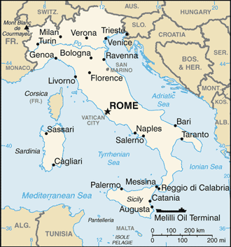
| Capital: | name: Rome geographic coordinates: 41 54 N , 12 29 E time difference: UTC+1 (6 hours ahead of Washington , DC during Standard Time) daylight saving time: +1hr , begins last Sunday in March; ends last Sunday in October |
| Climate: | predominantly Mediterranean; Alpine in far north; hot , dry in south |
| Currency code: | euro (EUR) |
| Ethnic groups: | Italian (includes small clusters of German- , French- , and Slovene-Italians in the north and Albanian-Italians and Greek-Italians in the south) |
| Geographic coordinates: | 42 50 N , 12 50 E |
| Geography note: | strategic location dominating central Mediterranean as well as southern sea and air approaches to Western Europe |
| Government type: | republic |
| Imports partners: | Germany 16.9% , France 9% , China 5.9% , Netherlands 5.5% , Belgium 4.3% , Spain 4.2% (2007) |
| Internet country code: | .it |
| Land boundaries: | 7 ,600 km |
| Neighbouring countries: | total: 1 ,899.2 km border countries: Austria 430 km , France 488 km , Holy See (Vatican City) 3.2 km , San Marino 39 km , Slovenia 199 km , Switzerland 740 km |
| Languages: | Italian (official) , German (parts of Trentino-Alto Adige region are predominantly German speaking) , French (small French-speaking minority in Valle d'Aosta region) , Slovene (Slovene-speaking minority in the Trieste-Gorizia area) |
| Location: | Southern Europe , a peninsula extending into the central Mediterranean Sea , northeast of Tunisia |
| Map references: | Europe |
| National holiday: | Republic Day , 2 June (1946) |
| Nationality: | noun: Italian(s) adjective: Italian |
| Natural hazards: | regional risks include landslides , mudflows , avalanches , earthquakes , volcanic eruptions , flooding; land subsidence in Venice |
| Population: | 58 ,145 ,320 (July 2008 est.) |
| Religions: | Roman Catholic 90% (approximately; about one-third practicing) , other 10% (includes mature Protestant and Jewish communities and a growing Muslim immigrant community) |
| Terrain: | mostly rugged and mountainous; some plains , coastal lowlands |
| Unemployment rate: | 6.2% (2007 est.) |
Capital of Italian Republic
Roma (click to view Roma map)
Places in Italy
Browse the most comprehensive and up-to-date online directory of administrative regions and Street views in Italy. Regions are sorted in alphabetical order from level 1 to level 2 and eventually up to level 3 regions.
Albiano city Google map
Albonese city Google map
Alpe di Dumenza city Google map
Angera city Google map
Aosta Valley (132 google map locations)
Apulia (405 google map locations)
Arcola city Google map
Arona city Google map
Arquata Scrivia city Google map
Arsago Seprio city Google map
Aulla city Google map
Avenza city Google map
Barbarasco city Google map
Basilicata (196 google map locations)
Bassignana city Google map
Bastida de' Dossi city Google map
Belgirate city Google map
Bellinzago Novarese city Google map
Bergiola Foscalina city Google map
Besano city Google map
Bolano city Google map
Borgo Lavezzaro city Google map
Borgo San Martino city Google map
Bozzole city Google map
Breme city Google map
Bric Castellaccio city Google map
Calabria (1120 google map locations)
Cameriano city Google map
Campania (773 google map locations)
Campione d'Italia city Google map
Candia Lomellina city Google map
Cannobio city Google map
Caresana city Google map
Carignano city Google map
Carrara city Google map
Casa Biscione city Google map
Casale San Antonio city Google map
Casalino city Google map
Cascina Borghetto city Google map
Cascina Grossa city Google map
Casei Gerola city Google map
Casorate Sempione city Google map
Cassolnovo city Google map
Castellaccio city Google map
Castelletto sopra Ticino city Google map
Castelletto Soprano city Google map
Castelletto Sottano city Google map
Castelnovetto city Google map
Castelnuovo di Magra city Google map
Castelnuovo Scrivia city Google map
Castelpoggio city Google map
Ceparana city Google map
Cerano city Google map
Cerro Lago Maggiore city Google map
Chalpe city Google map
Champsil city Google map
Cilavegna city Google map
Collodari city Google map
Comabbio city Google map
Confienza city Google map
Corgeno city Google map
Cornale city Google map
Costamala city Google map
Cozzo city Google map
Due Cossani city Google map
Dumenza city Google map
Emilia-Romagna (1683 google map locations)
Falcinello city Google map
Fosdinovo city Google map
Frassineto Po city Google map
Fresonara city Google map
Friuli-Venezia Giulia (676 google map locations)
Gaby city Google map
Gambarana city Google map
Gerola Nuova city Google map
Ghiffa city Google map
Gianona city Google map
Gignese city Google map
Golasecca city Google map
Gorzegno city Google map
Gragnana city Google map
Granozzo con Monticello city Google map
Gravellona city Google map
Groppo city Google map
Guazzora city Google map
Il Romito city Google map
Isola city Google map
Isola Sant'Antonio city Google map
Issime city Google map
Langosco city Google map
Lazio (870 google map locations)
Lesa city Google map
Liguria (581 google map locations)
Lillianes city Google map
Lombardy (1535 google map locations)
Luino city Google map
Lumellogno city Google map
Maccagno Inferiore city Google map
Maccagno Superiore city Google map
Malnate city Google map
Marche (721 google map locations)
Marciaso city Google map
Marina di Carrara city Google map
Marina di Massa city Google map
Marinella city Google map
Martina Olba city Google map
Meina city Google map
Mercallo city Google map
Molino Alzano city Google map
Molino del Conte city Google map
Molise (186 google map locations)
Monticello city Google map
Morosolo city Google map
Mortara city Google map
Motta de'Conti city Google map
Muggiano city Google map
Nicola city Google map
Nosate city Google map
Novegigola city Google map
Oleggio city Google map
Olgiate Comasco city Google map
Ortonovo city Google map
Palestro city Google map
Pallerone city Google map
Palmaro city Google map
Paruzzaro city Google map
Pecetto di Valenza city Google map
Pegli city Google map
Piampaludo city Google map
Piano di Follo city Google map
Piedicavallo city Google map
Piedmont (1175 google map locations)
Pieve del Cairo city Google map
Pino Lago Maggiore city Google map
Podenzana city Google map
Poggio city Google map
Pomaro Monferrato city Google map
Pombia city Google map
Ponte Tresa city Google map
Ponzana city Google map
Ponzanello city Google map
Porto Valtravaglia city Google map
Pra city Google map
Prazzo Inferiore city Google map
Prazzo Superiore city Google map
Province of Barletta-Andria-Trani city Google map
Province of Carbonia-Iglesias city Google map
Province of Ogliastra city Google map
Province of Olbia-Tempio city Google map
Provincia del Medio Campidano city Google map
Provincia di Fermo city Google map
Provincia di Monza e Brianza city Google map
Pugliola city Google map
Ranco city Google map
Rancotoschi city Google map
Robbio city Google map
Rosasco city Google map
Rosei city Google map
Sale city Google map
San Carlo city Google map
San Pietro d'Olba city Google map
San Terenzo city Google map
Santo Stefano di Magra city Google map
Sant'Angelo Lomellino city Google map
Sapello city Google map
Sardinia (591 google map locations)
Sarzana city Google map
Sarzanello city Google map
Sesto Calende city Google map
Sicily (819 google map locations)
Silvano Pietra city Google map
Somma Lombardo city Google map
Sorgnano city Google map
Suardi city Google map
Taino city Google map
Tendola city Google map
Terranova city Google map
Terrarossa city Google map
Ticineto city Google map
Tiglieto city Google map
Tornavento city Google map
Trebiano city Google map
Trentino-South Tyrol (608 google map locations)
Tronzano Lago Maggiore city Google map
Turbigo city Google map
Tuscany (1439 google map locations)
Uggiate city Google map
Umbria (644 google map locations)
Valenza city Google map
Valmacca city Google map
Varallo Pombia city Google map
Veneto (1416 google map locations)
Vergiate city Google map
Viggiù city Google map
Vignarello city Google map
Villa San Gaudenzio city Google map
Villanova city Google map
Vinzaglio city Google map
Vizzola Ticino city Google map
Voltri city Google map
Random cities in Italy
Roma, the capital city of Italy.Tolè
Quarona
Prato di Resia
Correggioverde
Perino
Fucine
Castellone
Boffalora sopra Ticino
Arola
Terelle
Petrognano
Al Gallo
Le Rucce
Santo Stefano al Mare
Anzola dell'Emilia
Silandro
Casere di Campo Manderiolo
Cella
Matera
This Italy map is for informational use only. No representation is made or warranty given as to its content. User assumes all risk of using Google Maps and Google Driving Directions. World Route Planner assumes no responsibility for any loss or delay resulting from such use of free Italy map.
Link to Italy Google Maps page
This map of Italy has been viewed 17776 times until now. In case you would like, there is a very easy way how to link to our Italy map - including free Google Maps, gazetteer search, country, city maps, Street View and facts -, ready to use on your website. Please, simply copy & paste the provided HTML code into your page source code: Thank you for all links to our Maps and Driving Directions!
| Text link to: Italy map |