 Bailiwick of Jersey Google Maps and Facts
Welcome to the Google Maps of Jersey (JE) and the comprehensive location list for this country. World Route Planner, together with its detailed Jersey page, turns Google Maps Sightseeing into a meaningful experience! Our extensive destination gazetteer, coupled with Driving Directions to Jersey, allows you to explore Jersey through detailed satellite imagery and street views—fast, free, and easier than ever before.
Browse through the list of administrative regions in Jersey, navigate through these regions to find a place of interest, and book your hotel with the Best Price Guarantee! Your journey through Jersey via Google Satellite Map Sightseeing and Street View starts here.
Jersey Google Maps
To activate Street View on any city of Jersey, drag above the Zoom feature the yellow little man in the map.
Facts about Jersey
| Administrative divisions: | none (British crown dependency); there are no first-order administrative divisions as defined by the US Government , but there are 12 parishes including Grouville , Saint Brelade , Saint Clement , Saint Helier , Saint John , Saint Lawrence , Saint Martin , Saint Mary , Saint Quen , Saint Peter , Saint Saviour , and Trinity |
| Area: | total: 116 sq km land: 116 sq km water: 0 sq km |
| Background: | Jersey and the other Channel Islands represent the last remnants of the medieval Dukedom of Normandy that held sway in both France and England. These islands were the only British soil occupied by German troops in World War II. Jersey is a British crown dependency but is not part of the UK. However , the UK Government is constitutionally responsible for its defense and international representation. |
| Flag description: | white with a diagonal red cross extending to the corners of the flag; in the upper quadrant , surmounted by a yellow crown , a red shield with the three lions of England in yellow |
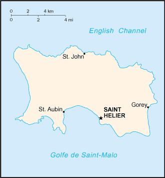
| Capital: | name: Saint Helier geographic coordinates: 49 11 N , 2 06 W time difference: UTC 0 (5 hours ahead of Washington , DC during Standard Time) daylight saving time: +1hr , begins last Sunday in March; ends last Sunday in October |
| Climate: | temperate; mild winters and cool summers |
| Currency code: | Jersey pound note: the British pound is also legal tender |
| Ethnic groups: | Jersey 51.1% , Britons 34.8% , Irish , French , and other white 6.6% , Portuguese/Madeiran 6.4% , other 1.1% (2001 census) |
| Geographic coordinates: | 49 15 N , 2 10 W |
| Geography note: | largest and southernmost of Channel Islands; about 30% of population concentrated in Saint Helier |
| Government type: | parliamentary democracy |
| Imports partners: | UK (2006) |
| Internet country code: | .je |
| Land boundaries: | 70 km |
| Neighbouring countries: | 0 km |
| Languages: | English 94.5% (official) , Portuguese 4.6% , other 0.9% (2001 census) |
| Location: | Western Europe , island in the English Channel , northwest of France |
| Map references: | Europe |
| National holiday: | Liberation Day , 9 May (1945) |
| Nationality: | noun: Channel Islander(s) adjective: Channel Islander |
| Natural hazards: | NA |
| Population: | 91 ,533 (July 2008 est.) |
| Religions: | Anglican , Roman Catholic , Baptist , Congregational New Church , Methodist , Presbyterian |
| Terrain: | gently rolling plain with low , rugged hills along north coast |
| Unemployment rate: | 2.2% (2006 est.) |
Capital of Bailiwick of Jersey
Saint Helier (click to view Saint Helier map)
Places in Jersey
Browse the most comprehensive and up-to-date online directory of administrative regions and Street Views in Jersey. Our listings are organized alphabetically, starting from level 1 regions and progressing through to level 2 and eventually level 3 regions, ensuring you can easily navigate and find specific areas of interest.
Bel Royal city Google map
Belle Vue city Google map
Gorey city Google map
Grand Chemins city Google map
Grand Mourier city Google map
La Falaise city Google map
La Fosse city Google map
La Haule city Google map
La Hougue city Google map
La Villaise city Google map
Le Rondin city Google map
Les Creux city Google map
Longueville city Google map
Lower Blanc Pignon city Google map
L'Etacq city Google map
Millbrook city Google map
Mount Mado city Google map
Perruque city Google map
Portinfer city Google map
Rozel city Google map
Saint Aubin city Google map
Saint Helier city Google map
Saint Johns Church city Google map
Saint Peters Church city Google map
Six Rues city Google map
Ville au Bas city Google map
Ville Bagot city Google map
Ville des Quennevais city Google map
Ville ès Nouaux city Google map
Vinchelez de Bas city Google map
Vinchelez de Haut city Google map
Random cities in Jersey
Saint Helier, the capital city of Jersey.Ville au Bas
Ville des Quennevais
Saint Johns Church
Ville ès Nouaux
Grand Chemins
La Villaise
Mont Fiquet
La Falaise
Gorey
Le Rondin
Saint Peters Church
Saint Helier
Six Rues
Belle Vue
L'Etacq
Mount Mado
La Hougue
Bel Royal
Vinchelez de Bas
Link to Jersey Google Maps page
The map of Jersey has already attracted 3866 views. If you wish to embed our comprehensive Jersey map on your site, we offer an easy solution. This map includes free access to Google Maps, gazetteer search, detailed country and city maps, Street View, and essential facts, all ready to enhance your website. To use it, simply copy and paste the provided HTML code into your webpage's source code. We appreciate every link back to our Maps and Driving Directions. Thank you for your support!
| Text link to: Jersey map and facts page |
This Jersey map is intended solely for informational purposes. No representations or warranties are made concerning its accuracy or reliability. Users assume all risks associated with the use of Google Maps and Google Driving Directions. World Route Planner is not liable for any losses or delays that may occur from using this free Jersey map.