 New Zealand Google Maps and Facts
Welcome to the Google Maps of New Zealand (NZ) and the comprehensive location list for this country. World Route Planner, together with its detailed New Zealand page, turns Google Maps Sightseeing into a meaningful experience! Our extensive destination gazetteer, coupled with Driving Directions to New Zealand, allows you to explore New Zealand through detailed satellite imagery and street views—fast, free, and easier than ever before.
Browse through the list of administrative regions in New Zealand, navigate through these regions to find a place of interest, and book your hotel with the Best Price Guarantee! Your journey through New Zealand via Google Satellite Map Sightseeing and Street View starts here.
New Zealand
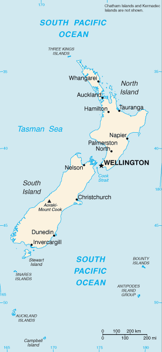
Lying 1500 miles east-southeast of Australia, New Zealand was originally settled by the Maori people of Polynesia. It was visited by Europeans for the first time only as recently as the 1770s. The islands’ rugged topography means that most settlement has concentrated in coastal areas. People of European origin make up about 70% of the population of 4 million, following immigration which began in the 1920s. Many recent settlers have come from Asia, including India and China, and a number of the Pacific islands. The Maori now make up a minority of less than half a million. Their ancient claims to at least half of national territory, however, are gaining increasing legal credence.New Zealand Google Maps
To activate Street View on any city of New Zealand, drag above the Zoom feature the yellow little man in the map.
The landscape
New Zealand comprises two large islands and many scattered smaller islands. On South Island the Alpine Fault marks the boundary between the Pacific and Indo-Australian plates. Tectonic activity has strongly influenced the formation of the Southern Alps, snowcapped mountains with several peaks over 9800 ft (3000 m). North Island has a lower and less extensive mountain region, containing forested hills, a central volcanic plateau, and downlands.Transportation & industry
Wool, meat, and dairy products contribute to over 30% of New Zealand’s export revenues. The manufacturing sector is growing with the emphasis on hi-tech. Steep slopes and fast-flowing rivers have enabled the production of an excess of hydroelectric power. The forestry industry increasingly aims at afforestation, with pinetrees grown for pulp and timber rather than the felling of native species.Using the land & sea
The climate and topography of North Island are more favorable to agriculture than the harsher terrain of South Island. Sheep and cattle can graze in summer and winter on the rich pastures surrounding both Auckland and Christchurch. A wide range of crops including vegetables, cereals, and fruits such as grapes and kiwifruit, are grown in the northern parts of New Zealand. The rich Pacific fisheries are of increasing economic importance.Facts about New Zealand
| Administrative divisions: | 16 regions and 1 territory*; Auckland , Bay of Plenty , Canterbury , Chatham Islands* , Gisborne , Hawke's Bay , Manawatu-Wanganui , Marlborough , Nelson , Northland , Otago , Southland , Taranaki , Tasman , Waikato , Wellington , West Coast |
| Area: | total: 268 ,680 sq km land: 268 ,021 sq km water: NA note: includes Antipodes Islands , Auckland Islands , Bounty Islands , Campbell Island , Chatham Islands , and Kermadec Islands |
| Background: | The Polynesian Maori reached New Zealand in about A.D. 800. In 1840 , their chieftains entered into a compact with Britain , the Treaty of Waitangi , in which they ceded sovereignty to Queen Victoria while retaining territorial rights. In that same year , the British began the first organized colonial settlement. A series of land wars between 1843 and 1872 ended with the defeat of the native peoples. The British colony of New Zealand became an independent dominion in 1907 and supported the UK militarily in both World Wars. New Zealand's full participation in a number of defense alliances lapsed by the 1980s. In recent years , the government has sought to address longstanding Maori grievances. |
| Flag description: | blue with the flag of the UK in the upper hoist-side quadrant with four red five-pointed stars edged in white centered in the outer half of the flag; the stars represent the Southern Cross constellation |
| Capital: | name: Wellington geographic coordinates: 41 28 S , 174 51 E time difference: UTC+12 (17 hours ahead of Washington , DC during Standard Time) daylight saving time: +1hr , begins first Sunday in October; ends third Sunday in March note: New Zealand is divided into two time zones , including Chatham Island |
| Climate: | temperate with sharp regional contrasts |
| Currency code: | New Zealand dollar (NZD) |
| Ethnic groups: | European 69.8% , Maori 7.9% , Asian 5.7% , Pacific islander 4.4% , other 0.5% , mixed 7.8% , unspecified 3.8% (2001 census) |
| Geographic coordinates: | 41 00 S , 174 00 E |
| Geography note: | about 80% of the population lives in cities; Wellington is the southernmost national capital in the world |
| Government type: | parliamentary democracy |
| Imports partners: | Australia 20.7% , China 13.4% , US 9.7% , Japan 9.5% , Singapore 4.9% , Germany 4.7% (2007) |
| Internet country code: | .nz |
| Land boundaries: | 15 ,134 km |
| Neighbouring countries: | 0 km |
| Languages: | English (official) , Maori (official) , Sign Language (official) |
| Location: | Oceania , islands in the South Pacific Ocean , southeast of Australia |
| Map references: | Oceania |
| National holiday: | Waitangi Day (Treaty of Waitangi established British sovereignty over New Zealand) , 6 February (1840); ANZAC Day (commemorated as the anniversary of the landing of troops of the Australian and New Zealand Army Corps during World War I at Gallipoli , Turkey) , 25 April (1915) |
| Nationality: | noun: New Zealander(s) adjective: New Zealand |
| Natural hazards: | earthquakes are common , though usually not severe; volcanic activity |
| Population: | 4 ,173 ,460 (July 2008 est.) |
| Religions: | Anglican 14.9% , Roman Catholic 12.4% , Presbyterian 10.9% , Methodist 2.9% , Pentecostal 1.7% , Baptist 1.3% , other Christian 9.4% , other 3.3% , unspecified 17.2% , none 26% (2001 census) |
| Terrain: | predominately mountainous with some large coastal plains |
| Unemployment rate: | 3.6% (2007 est.) |
Capital of New Zealand
Wellington (click to view Wellington map)
Places in New Zealand
Browse the most comprehensive and up-to-date online directory of administrative regions and Street Views in New Zealand. Our listings are organized alphabetically, starting from level 1 regions and progressing through to level 2 and eventually level 3 regions, ensuring you can easily navigate and find specific areas of interest.
Bay of Plenty (94 google map locations)
Canterbury (309 google map locations)
Chatham Islands (11 google map locations)
Gisborne (46 google map locations)
Hawke's Bay (88 google map locations)
Manawatu-Wanganui (208 google map locations)
Marlborough (84 google map locations)
Nelson (1 google map locations)
Otago (281 google map locations)
Southland (167 google map locations)
Taranaki (128 google map locations)
Tasman (89 google map locations)
Waikato (228 google map locations)
Wellington (83 google map locations)
West Coast (143 google map locations)
Random cities in New Zealand
Wellington, the capital city of New Zealand.The Reefs
Berhampore
Omanawa
Tuhipa
Millers Flat
Puketotara
Kaitangata
Waimatuku
West Plains
Popotunoa
Kahuika
Mapua
Tahere
Mandeville North
Mount Maunganui
Taurikura
Clarence
Waihoaka
Spring Grove
Link to New Zealand Google Maps page
The map of New Zealand has already attracted 7423 views. If you wish to embed our comprehensive New Zealand map on your site, we offer an easy solution. This map includes free access to Google Maps, gazetteer search, detailed country and city maps, Street View, and essential facts, all ready to enhance your website. To use it, simply copy and paste the provided HTML code into your webpage's source code. We appreciate every link back to our Maps and Driving Directions. Thank you for your support!
| Text link to: New Zealand map and facts page |
This New Zealand map is intended solely for informational purposes. No representations or warranties are made concerning its accuracy or reliability. Users assume all risks associated with the use of Google Maps and Google Driving Directions. World Route Planner is not liable for any losses or delays that may occur from using this free New Zealand map.