 Independent State of Papua New Guinea Google Maps and facts
Welcome to Google Maps of Papua New Guinea (PG) and locations list of this country. World Route Planner and its detailed Papua New Guinea page is the place where Google Maps Sightseeing make sense! With comprehensive destination gazetteer, Driving Directions to Papua New Guinea, World Route Planner enables you to explore Papua New Guinea through detailed Satellite Imagery and Street View - fast, free and easy as never before. Browse the list of administrative regions below of Papua New Guinea, follow the navigation through administrative regions to find a place you are interested in and Book your hotel with Best Price Guarantee! Your Papua New Guinea Google Satellite Map Sightseeing and Street View start here.
To activate Street View on any city of Papua New Guinea, drag above the Zoom feature the yellow little man in the map.
Facts about Papua New Guinea
| Administrative divisions: | 20 provinces; Bougainville , Central , Chimbu , Eastern Highlands , East New Britain , East Sepik , Enga , Gulf , Madang , Manus , Milne Bay , Morobe , National Capital , New Ireland , Northern , Sandaun , Southern Highlands , Western , Western Highlands , West New Britain |
| Area: | total: 462 ,840 sq km land: 452 ,860 sq km water: 9 ,980 sq km Paracel Islands |
| Background: | The eastern half of the island of New Guinea - second largest in the world - was divided between Germany (north) and the UK (south) in 1885. The latter area was transferred to Australia in 1902 , which occupied the northern portion during World War I and continued to administer the combined areas until independence in 1975. A nine-year secessionist revolt on the island of Bougainville ended in 1997 after claiming some 20 ,000 lives. Paracel Islands |
| Flag description: | divided diagonally from upper hoist-side corner; the upper triangle is red with a soaring yellow bird of paradise centered; the lower triangle is black with five , white , five-pointed stars of the Southern Cross constellation centered |
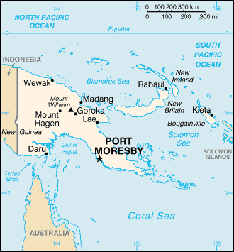
| Capital: | name: Port Moresby geographic coordinates: 9 30 S , 147 10 E time difference: UTC+10 (15 hours ahead of Washington , DC during Standard Time) |
| Climate: | tropical; northwest monsoon (December to March) , southeast monsoon (May to October); slight seasonal temperature variation Paracel Islands |
| Currency code: | kina (PGK) |
| Ethnic groups: | Melanesian , Papuan , Negrito , Micronesian , Polynesian |
| Geographic coordinates: | 6 00 S , 147 00 E Paracel Islands |
| Geography note: | shares island of New Guinea with Indonesia; one of world's largest swamps along southwest coast Paracel Islands |
| Government type: | constitutional parliamentary democracy |
| Imports partners: | Australia 50.9% , Singapore 11.3% , China 7.7% , Japan 5.5% (2007) |
| Internet country code: | .pg |
| Land boundaries: | 5 ,152 km Paracel Islands |
| Neighbouring countries: | total: 820 km border countries: Indonesia 820 km Paracel Islands |
| Languages: | Melanesian Pidgin serves as the lingua franca , English spoken by 1%-2% , Motu spoken in Papua region note: 820 indigenous languages spoken (over one-tenth of the world's total) |
| Location: | Oceania , group of islands including the eastern half of the island of New Guinea between the Coral Sea and the South Pacific Ocean , east of Indonesia Paracel Islands |
| Map references: | Oceania Paracel Islands |
| National holiday: | Independence Day , 16 September (1975) |
| Nationality: | noun: Papua New Guinean(s) adjective: Papua New Guinean |
| Natural hazards: | active volcanism; situated along the Pacific "Ring of Fire"; the country is subject to frequent and sometimes severe earthquakes; mud slides; tsunamis Paracel Islands |
| Population: | 5 ,931 ,769 (July 2008 est.) Paracel Islands |
| Religions: | Roman Catholic 27% , Evangelical Lutheran 19.5% , United Church 11.5% , Seventh-Day Adventist 10% , Pentecostal 8.6% , Evangelical Alliance 5.2% , Anglican 3.2% , Baptist 2.5% , other Protestant 8.9% , Bahai 0.3% , indigenous beliefs and other 3.3% (2000 census) |
| Terrain: | mostly mountains with coastal lowlands and rolling foothills Paracel Islands |
| Unemployment rate: | 1.9% up to 80% in urban areas (2004) |
Capital of Independent State of Papua New Guinea
Port Moresby (click to view Port Moresby map)
Places in Papua New Guinea
Browse the most comprehensive and up-to-date online directory of administrative regions and Street views in Papua New Guinea. Regions are sorted in alphabetical order from level 1 to level 2 and eventually up to level 3 regions.
Central Province (668 google map locations)
Chimbu Province (561 google map locations)
East New Britain Province (434 google map locations)
East Sepik Province (1126 google map locations)
Eastern Highlands Province (820 google map locations)
Enga Province (82 google map locations)
Gulf Province (521 google map locations)
Madang Province (1049 google map locations)
Manus Province (125 google map locations)
Morobe Province (872 google map locations)
National Capital District (37 google map locations)
New Ireland Province (524 google map locations)
Northern Province (502 google map locations)
Southern Highlands Province (590 google map locations)
West New Britain Province (370 google map locations)
West Sepik Province (792 google map locations)
Western Highlands Province (178 google map locations)
Western Province (785 google map locations)
Random cities in Papua New Guinea
Port Moresby, the capital city of Papua New Guinea.Mahdemu
Gambumanaweia
Amiagour
Pompameri
Bimat
Munimun
Yokua
Ralubang
Dowaning
Kwiop
Gogonbagu
Popagwabi
Meagio
Kwieftim
Pelagai
Wanimbun
Biapiarata
Baibai
Komonokane
This Papua New Guinea map is for informational use only. No representation is made or warranty given as to its content. User assumes all risk of using Google Maps and Google Driving Directions. World Route Planner assumes no responsibility for any loss or delay resulting from such use of free Papua New Guinea map.
Link to Papua New Guinea Google Maps page
This map of Papua New Guinea has been viewed 7136 times until now. In case you would like, there is a very easy way how to link to our Papua New Guinea map - including free Google Maps, gazetteer search, country, city maps, Street View and facts -, ready to use on your website. Please, simply copy & paste the provided HTML code into your page source code: Thank you for all links to our Maps and Driving Directions!
| Text link to: Papua New Guinea map |