 Kingdom of Tonga Google Maps and Facts
Welcome to the Google Maps of Tonga (TO) and the comprehensive location list for this country. World Route Planner, together with its detailed Tonga page, turns Google Maps Sightseeing into a meaningful experience! Our extensive destination gazetteer, coupled with Driving Directions to Tonga, allows you to explore Tonga through detailed satellite imagery and street views—fast, free, and easier than ever before.
Browse through the list of administrative regions in Tonga, navigate through these regions to find a place of interest, and book your hotel with the Best Price Guarantee! Your journey through Tonga via Google Satellite Map Sightseeing and Street View starts here.
Tonga Google Maps
To activate Street View on any city of Tonga, drag above the Zoom feature the yellow little man in the map.
Facts about Tonga
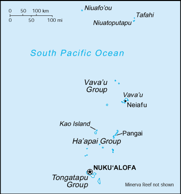
| Administrative divisions: | 3 island groups; Ha'apai , Tongatapu , Vava'u |
| Area: | total: 748 sq km land: 718 sq km water: 30 sq km |
| Background: | Tonga - unique among Pacific nations - never completely lost its indigenous governance. The archipelagos of "The Friendly Islands" were united into a Polynesian kingdom in 1845. Tonga became a constitutional monarchy in 1875 and a British protectorate in 1900; it withdrew from the protectorate and joined the Commonwealth of Nations in 1970. Tonga remains the only monarchy in the Pacific. |
| Flag description: | red with a bold red cross on a white rectangle in the upper hoist-side corner |
| Capital: | name: Nuku'alofa geographic coordinates: 21 08 S , 175 12 W time difference: UTC+13 (18 hours ahead of Washington , DC during Standard Time) |
| Climate: | tropical; modified by trade winds; warm season (December to May) , cool season (May to December) |
| Currency code: | |
| Ethnic groups: | Polynesian , Europeans |
| Geographic coordinates: | 20 00 S , 175 00 W |
| Geography note: | archipelago of 169 islands (36 inhabited) |
| Government type: | constitutional monarchy |
| Imports partners: | Fiji 32.3% , NZ 27.4% , US 9% , Australia 7.6% , China 5% (2007) |
| Internet country code: | .to |
| Land boundaries: | 419 km |
| Neighbouring countries: | 0 km |
| Languages: | Tongan , English |
| Location: | Oceania , archipelago in the South Pacific Ocean , about two-thirds of the way from Hawaii to New Zealand |
| Map references: | Oceania |
| National holiday: | Emancipation Day , 4 June (1970) |
| Nationality: | noun: Tongan(s) adjective: Tongan |
| Natural hazards: | cyclones (October to April); earthquakes and volcanic activity on Fonuafo'ou |
| Population: | 119 ,009 (July 2008 est.) |
| Religions: | Christian (Free Wesleyan Church claims over 30 ,000 adherents) |
| Terrain: | most islands have limestone base formed from uplifted coral formation; others have limestone overlying volcanic base |
| Unemployment rate: | 13% (FY03/04 est.) |
Capital of Kingdom of Tonga
Nuku`alofa (click to view Nuku`alofa map)
Places in Tonga
Browse the most comprehensive and up-to-date online directory of administrative regions and Street Views in Tonga. Our listings are organized alphabetically, starting from level 1 regions and progressing through to level 2 and eventually level 3 regions, ensuring you can easily navigate and find specific areas of interest.
Random cities in Tonga
Nuku`alofa, the capital city of Tonga.Ha`akame
Ha`atafu
Faleono
Ha`avakatolo
Makave
Leimatu`a
Lotofoa
Puke
Haalaufuli
Makaunga
Tofoa
Holonga
Tu`anekivale
Hatou
Pangai
Veitongo
Nakolo
Mataika
Faleloa
Link to Tonga Google Maps page
The map of Tonga has already attracted 3690 views. If you wish to embed our comprehensive Tonga map on your site, we offer an easy solution. This map includes free access to Google Maps, gazetteer search, detailed country and city maps, Street View, and essential facts, all ready to enhance your website. To use it, simply copy and paste the provided HTML code into your webpage's source code. We appreciate every link back to our Maps and Driving Directions. Thank you for your support!
| Text link to: Tonga map and facts page |
This Tonga map is intended solely for informational purposes. No representations or warranties are made concerning its accuracy or reliability. Users assume all risks associated with the use of Google Maps and Google Driving Directions. World Route Planner is not liable for any losses or delays that may occur from using this free Tonga map.