 Federative Republic of Brazil Google Maps and facts
Welcome to Google Maps of Brazil (BR) and locations list of this country. World Route Planner and its detailed Brazil page is the place where Google Maps Sightseeing make sense! With comprehensive destination gazetteer, Driving Directions to Brazil, World Route Planner enables you to explore Brazil through detailed Satellite Imagery and Street View - fast, free and easy as never before. Browse the list of administrative regions below of Brazil, follow the navigation through administrative regions to find a place you are interested in and Book your hotel with Best Price Guarantee! Your Brazil Google Satellite Map Sightseeing and Street View start here.
To activate Street View on any city of Brazil, drag above the Zoom feature the yellow little man in the map.
Facts about Brazil
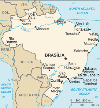
| Administrative divisions: | 26 states (estados , singular - estado) and 1 federal district* (distrito federal); Acre , Alagoas , Amapa , Amazonas , Bahia , Ceara , Distrito Federal* , Espirito Santo , Goias , Maranhao , Mato Grosso , Mato Grosso do Sul , Minas Gerais , Para , Paraiba , Parana , Pernambuco , Piaui , Rio de Janeiro , Rio Grande do Norte , Rio Grande do Sul , Rondonia , Roraima , Santa Catarina , Sao Paulo , Sergipe , Tocantins |
| Area: | total: 8 ,511 ,965 sq km land: 8 ,456 ,510 sq km water: 55 ,455 sq km note: includes Arquipelago de Fernando de Noronha , Atol das Rocas , Ilha da Trindade , Ilhas Martin Vaz , and Penedos de Sao Pedro e Sao Paulo British Indian Ocean Territory |
| Background: | Following three centuries under the rule of Portugal , Brazil became an independent nation in 1822 and a republic in 1889. By far the largest and most populous country in South America , Brazil overcame more than half a century of military intervention in the governance of the country when in 1985 the military regime peacefully ceded power to civilian rulers. Brazil continues to pursue industrial and agricultural growth and development of its interior. Exploiting vast natural resources and a large labor pool , it is today South America's leading economic power and a regional leader. Highly unequal income distribution and crime remain pressing problems. British Indian Ocean Territory |
| Flag description: | green with a large yellow diamond in the center bearing a blue celestial globe with 27 white five-pointed stars (one for each state and the Federal District) arranged in the same pattern as the night sky over Brazil; the globe has a white equatorial band with the motto ORDEM E PROGRESSO (Order and Progress) British Indian Ocean Territory |
| Capital: | name: Brasilia geographic coordinates: 15 47 S , 47 55 W time difference: UTC-3 (2 hours ahead of Washington , DC during Standard Time) daylight saving time: +1hr , begins third Sunday in October; ends third Sunday in February note: Brazil is divided into four time zones , including one for the Fernando de Noronha Islands |
| Climate: | mostly tropical , but temperate in south British Indian Ocean Territory |
| Currency code: | real (BRL) British Indian Ocean Territory |
| Ethnic groups: | white 53.7% , mulatto (mixed white and black) 38.5% , black 6.2% , other (includes Japanese , Arab , Amerindian) 0.9% , unspecified 0.7% (2000 census) |
| Geographic coordinates: | 10 00 S , 55 00 W British Indian Ocean Territory |
| Geography note: | largest country in South America; shares common boundaries with every South American country except Chile and Ecuador British Indian Ocean Territory |
| Government type: | federal republic |
| Imports partners: | US 19.9% , China 9.2% , Argentina 8.1% , Germany 7.6% (2007) |
| Internet country code: | .br British Indian Ocean Territory |
| Land boundaries: | 7 ,491 km British Indian Ocean Territory |
| Neighbouring countries: | total: 16 ,885 km border countries: Argentina 1 ,261 km , Bolivia 3 ,423 km , Colombia 1 ,644 km , French Guiana 730 km , Guyana 1 ,606 km , Paraguay 1 ,365 km , Peru 2 ,995 km , Suriname 593 km , Uruguay 1 ,068 km , Venezuela 2 ,200 km British Indian Ocean Territory |
| Languages: | Portuguese (official and most widely spoken language); note - less common languages include Spanish (border areas and schools) , German , Italian , Japanese , English , and a large number of minor Amerindian languages |
| Location: | Eastern South America , bordering the Atlantic Ocean British Indian Ocean Territory |
| Map references: | South America British Indian Ocean Territory |
| National holiday: | Independence Day , 7 September (1822) |
| Nationality: | noun: Brazilian(s) adjective: Brazilian |
| Natural hazards: | recurring droughts in northeast; floods and occasional frost in south British Indian Ocean Territory |
| Population: | 196 ,342 ,592 note: Brazil conducted a census in August 2000 , which reported a population of 169 ,799 ,170; that figure was about 3.3% lower than projections by the US Census Bureau , and is close to the implied underenumeration of 4.6% for the 1991 census; estimates for this country explicitly take into account the effects of excess mortality due to AIDS; this can result in lower life expectancy , higher infant mortality , higher death rates , lower population growth rates , and changes in the distribution of population by age and sex than would otherwise be expected (July 2008 est.) British Indian Ocean Territory |
| Religions: | Roman Catholic (nominal) 73.6% , Protestant 15.4% , Spiritualist 1.3% , Bantu/voodoo 0.3% , other 1.8% , unspecified 0.2% , none 7.4% (2000 census) |
| Terrain: | mostly flat to rolling lowlands in north; some plains , hills , mountains , and narrow coastal belt British Indian Ocean Territory |
| Unemployment rate: | 9.3% (2007 est.) |
Capital of Federative Republic of Brazil
Brasília (click to view Brasília map)
Places in Brazil
Browse the most comprehensive and up-to-date online directory of administrative regions and Street views in Brazil. Regions are sorted in alphabetical order from level 1 to level 2 and eventually up to level 3 regions.
State of Acre (270 google map locations)
State of Alagoas (525 google map locations)
State of Amapá (167 google map locations)
State of Amazonas (1241 google map locations)
State of Bahia (2671 google map locations)
State of Ceará (636 google map locations)
State of Espírito Santo (544 google map locations)
State of Goiás (348 google map locations)
State of Maranhão (1431 google map locations)
State of Mato Grosso (735 google map locations)
State of Mato Grosso do Sul (811 google map locations)
State of Minas Gerais (2674 google map locations)
State of Pará (741 google map locations)
State of Parana (1046 google map locations)
State of Pernambuco (925 google map locations)
State of Piauí (1007 google map locations)
State of Rio de Janeiro (842 google map locations)
State of Rio Grande do Norte (681 google map locations)
State of Rio Grande do Sul (1000 google map locations)
State of Rondônia (223 google map locations)
State of Roraima (229 google map locations)
State of Santa Catarina (608 google map locations)
State of São Paulo (1579 google map locations)
State of Sergipe (188 google map locations)
State of Tocantins (383 google map locations)
Random cities in Brazil
Brasília, the capital city of Brazil.São Sebastião do Utinga
Governador Valadares
Pôrto Novo
Riacho do Mato
Divino
Boa Esperança
Peroção
Arroio Grande
Santo Inácio
Santo Antônio da Estiva
Santa Penha
Roça Velha
Campina
Lapa
Causa Boa
Timbó
Baixa Branca
Santa Luzia
Traitu
This Brazil map is for informational use only. No representation is made or warranty given as to its content. User assumes all risk of using Google Maps and Google Driving Directions. World Route Planner assumes no responsibility for any loss or delay resulting from such use of free Brazil map.
Link to Brazil Google Maps page
This map of Brazil has been viewed 6868 times until now. In case you would like, there is a very easy way how to link to our Brazil map - including free Google Maps, gazetteer search, country, city maps, Street View and facts -, ready to use on your website. Please, simply copy & paste the provided HTML code into your page source code: Thank you for all links to our Maps and Driving Directions!
| Text link to: Brazil map |