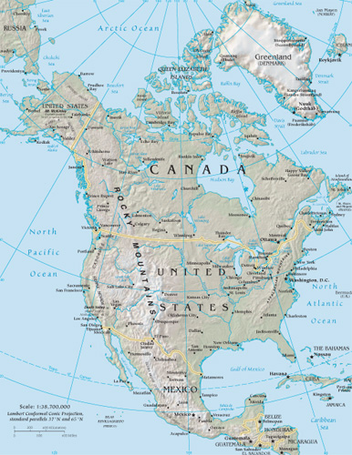
North America Google Maps
The landscape of global sovereignty has dramatically shifted over the past several decades. From just 82 sovereign states in 1950, the number has surged to almost 200 today. This rise can largely be attributed to the fervent push for national self-determination following eras of colonialism and oppression. As the world map has become increasingly dotted with more borders, international border disputes have simultaneously risen. Often fueled by religious or ethnic motivations, these newfound independences have sometimes led to intense internal conflicts, particularly with minority groups. While many nations have transitioned into independence with relative peace, adopting forms of government ranging from multiparty democracies to more centralized powers, others have experienced tumultuous power struggles, occasionally resulting in military dictatorships or individual despots. These early stages of nationhood are critical in shaping the future of emerging states.
World Route Planner offers an extensive North America gazetteer, powered by Google Maps, providing detailed Driving Directions and Google Street View across the cities of North America. Our collaboration with Google Maps delivers the most comprehensive online satellite imagery available, enhancing your exploration of North America. Our database covers thousands of locations in North America, categorized by countries, counties, administrative regions, and cities. Additionally, World Route Planner provides precise Time Zones and Daylight maps for North America. Take advantage of this wealth of information and start exploring North America with Google Maps today!
Google Maps of North America
To access Google Street View for any city in North America, simply drag the yellow pegman icon located above the zoom controls directly onto the map. This will activate the Street View feature, allowing you to explore the streets and landmarks of North America up close.
Facts of North America
North America is the world’s third largest continent, with a total area of 9,358,340 sq miles (24,238,000 sq km), including Greenland and the Caribbean islands. It lies wholly within the Northern Hemisphere.- Greatest extent, North-South: 4600 miles / 7400 km
- Greatest extent, East-West: 3500 miles / 5700 km
- Most westerly point: Attu, Aleutian Islands, USA 172° 30’ E
- Most northerly point: Kap Morris Jesup, northern Greenland 83° 38’ N
- Most southerly point: Península de Azuero, southeast Panama 7° 15’ N
- Most easterly point: Nordøstrundingen, northeast Greenland 12° 08’ W
- Highest recorded temperature: Death Valley, California, USA 135°F (57°C )
- Lowest recorded temperature: Northice, Greenland -87° F (-66° C)
- Highest point: Mount McKinley (Denali), Alaska, USA 20,322 ft (6194 m)
- Lowest point: Death Valley, California, USA -282 ft (-86 m) below sea level
- Largest lake: Lake Superior, Canada/USA 32,142 sq miles (83,270 sq km)
Climate
North America’s climate includes extremes ranging from freezing Arctic conditions in Alaska and Greenland to desert in the southwest and tropical conditions in southeastern Florida, the Caribbean, and Central America. Central and southern regions are prone to severe storms, including tornadoes and hurricanes.Shaping the continent
Glacial processes affect much of northern Canada, Greenland, and the Western Cordillera. Along the western coast of North America, Central America, and the Caribbean, underlying plates moving together lead to earthquakes and volcanic eruptions. The vast river systems, fed by mountain streams, constantly erode and deposit material along their paths.Political North America
Democracy is well-established in some parts of the continent but is a recent phenomenon in others. The economically dominant nations of Canada and the US have a long democratic tradition, but elsewhere, notably in the countries of Central America, political turmoil has become more common. In Nicaragua and Haiti, harsh dictatorships have only recently been superseded by democratically elected governments. North America’s largest countries, Canada, Mexico, and the US have federal-state systems that share political power between national and state governments. The US has intervened militarily on several occasions in Central America and the Caribbean to protect its strategic interests.Transportation
In the 19th century, railroads opened up the North American continent. Air transportation is now more common for long-distance passenger travel, although railroads are still extensively used for bulk freight transportation. Waterways like the Mississippi River are important for transporting bulk materials, and the Panama Canal is a vital link between the Pacific and Atlantic Oceans. In the 20th century, road transportation increased massively by introducing cheap, mass-produced motor cars and extensive highway construction.Population
Much of North America is almost empty, especially the frozen far north. Population densities are highest in the highlands of Mexico and Central America, the coastal plain stretching from the Gulf of Mexico along the Atlantic coast, the Great Lakes area, and the Pacific coast. Large conurbations have developed, notably the San-San (San Francisco – San Diego), Boswash (Boston – Washington), and Main Street (Toronto – Montréal). The populations of the Caribbean islands are small, but settlements are dense due to the limited amount of land available.Languages
The three major official languages of North America are of European origin, brought by settlers in the 16th century. In Canada, French and English are spoken; in the US, English is the main language, with large Spanish-speaking areas in the southwest; Mexicans are Spanish-speaking, while the Caribbean islands use French, English, and Spanish as well as the hybrid Creole tongues. In isolated areas, languages of the indigenous peoples still exist, such as Inuit in the far north of the continent.North American resources
The two northern countries of Canada and the US are richly endowed with natural resources that have helped to fuel economic development. The US is the world’s largest economy, although it faces stiff competition from the Far East today. Mexico has relied on oil revenues, but there is hope that the North American Free Trade Agreement (NAFTA) will encourage trade growth with Canada and the US. The poorer countries of Central America and the Caribbean depend largely on cash crops and tourism.Industry
The modern, industrialized economies of the US and Canada contrast sharply with those of Mexico, Central America, and the Caribbean. Manufacturing is especially important in the US; vehicle production is concentrated around the Great Lakes, while electronic and hi-tech industries are increasingly found in the western and southern states. Mexico depends on oil exports and assembly work, exploiting cheap labor. Many Central American and Caribbean countries rely heavily on agricultural exports.Standard of living
The US and Canada have one of the world's highest overall living standards. However, many people still live in poverty, especially in urban ghettos and some rural areas. Central America and the Caribbean are markedly poorer than their wealthier northern neighbors. Haiti is the poorest country in the Western Hemisphere.Environmental issues
Many fragile environments are under threat throughout the region. Haiti's primary rainforests have been destroyed, while air pollution from factories and cars in Mexico City is among the worst in the world. Elsewhere, industry and mining pose threats, particularly in the delicate arctic environment of Alaska, where oil spills have polluted coastlines and decimated fish stocks.Mineral resources
Fossil fuels are exploited in considerable quantities throughout the continent. Coal mining in the Appalachians is declining, but vast open pits exist further west in Wyoming. Oil and natural gas are found in Alaska, Texas, the Gulf of Mexico, and the Canadian West. Canada has large quantities of nickel, while Jamaica has considerable deposits of bauxite, and Mexico has large reserves of silver.Using the land and sea
Abundant land and fertile soils stretch from the Canadian prairies to Texas creating North America’s agricultural heartland. Cereals and cattle ranching form the basis of the farming economy, and corn and soybeans are also important. Fruit and vegetables are grown in California using irrigation, while Florida is a leading producer of citrus fruits. Caribbean and Central American countries depend on cash crops such as bananas, coffee, and sugar cane, often grown on large plantations. This reliance on a single crop can leave these countries vulnerable to fluctuating world crop prices.Countries in North America with Google Maps and Gazetteers
Browse the most comprehensive and up-to-date online directory of countries and administrative regions in North America. Our listings are sorted alphabetically from level 1 to level 2 and up to level 3 regions, ensuring you can easily find specific locations. Integrated with Google Maps and Driving Directions, we provide all the necessary tools to explore North America. Don't wait—start exploring the unique regions and beautiful countries of North America today.
The Nature of Politics
Democracy encompasses a wide spectrum of governance practices. In its most robust form, it involves multiparty elections and fair representation. However, in some contexts, such as in Singapore, what is termed democracy can closely resemble single-party rule, where alternative political competition is limited. Conversely, in despotic regimes, power is consolidated in the hands of a single authority, often ruling through personal decree rather than through democratic processes. In such systems, institutions like the parliament and the military typically function as extensions of the dictator's will, rather than as independent entities serving the public.
The Changing World Map
As of 1950, extensive regions globally remained under the dominion of a few European countries. The decolonization process began in Asia post-World War II, where countries in southern and southeastern Asia pursued and achieved self-determination. By the 1960s, numerous African states had gained independence, significantly reducing the scope of European overseas empires by 1965. The final major phase of decolonization occurred with the dissolution of the Soviet Union and the Eastern bloc after 1990. Today, the decolonization process persists as the remaining vestiges of European colonialism, often small island nations, increasingly advocate for independence.
International boundary determinations can be based on various criteria. Borders of older states often follow natural features; others reflect religious and ethnic divides; some are remnants of complicated histories of conflict and colonialism, while others result from international agreements or arbitration.
Post-colonial borders
As European colonial empires in Africa were dismantled in the latter half of the 20th century, the resulting African state borders often replicated the colonial lines. These were drawn by colonial administrators who frequently lacked adequate geographical knowledge, leading to arbitrary divisions among people of different languages, races, religions, and customs. This confused legacy has often resulted in civil and international conflicts.
Physical borders
Many of the world's countries are delineated by physical borders such as lakes, rivers, and mountains. However, demarcating these boundaries can lead to disputes over the control of waterways, water resources, and fisheries, which are common causes of international contention.
International disputes
Today, there are over 60 disputed borders or territories globally. While many of these disputes may be resolved through peaceful negotiations, certain areas have become focal points for international conflicts. Ethnic tensions and the quest for valuable natural resources have historically been significant sources of territorial disputes. The turmoil experienced in parts of Africa during the postcolonial era is partly due to the 19th-century division of the continent, which sowed seeds of conflict by imposing often arbitrary boundaries across linguistic and cultural zones.
Link to North America Google Maps Page:
Explore our comprehensive map of North America, which has been viewed 89044 times to date. If you're interested in integrating our North America map into your website, we offer a seamless method for doing so. Our map includes valuable features such as free Google Maps access, Gazetteer Search, detailed maps of countries and cities, Street View, Driving Directions, and key facts about North America. Simply copy and paste the HTML code provided below into your website to enhance it with our detailed mapping tools. We appreciate your support and links to World Route Planner!
| Text link to: North America map and facts page |
This North America map is provided for informational purposes only. No guarantees are made regarding its accuracy or completeness. Users assume all risks associated with the use of Google Maps and Google Driving Directions. World Route Planner is not responsible for any loss or delays that may occur as a result of using this free North America map.