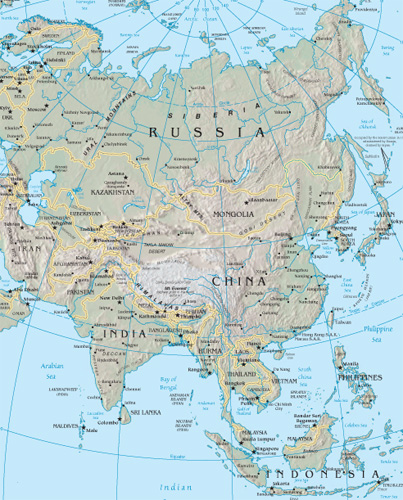
Asia Google Maps
The landscape of global sovereignty has dramatically shifted over the past several decades. From just 82 sovereign states in 1950, the number has surged to almost 200 today. This rise can largely be attributed to the fervent push for national self-determination following eras of colonialism and oppression. As the world map has become increasingly dotted with more borders, international border disputes have simultaneously risen. Often fueled by religious or ethnic motivations, these newfound independences have sometimes led to intense internal conflicts, particularly with minority groups. While many nations have transitioned into independence with relative peace, adopting forms of government ranging from multiparty democracies to more centralized powers, others have experienced tumultuous power struggles, occasionally resulting in military dictatorships or individual despots. These early stages of nationhood are critical in shaping the future of emerging states.
World Route Planner offers an extensive Asia gazetteer, powered by Google Maps, providing detailed Driving Directions and Google Street View across the cities of Asia. Our collaboration with Google Maps delivers the most comprehensive online satellite imagery available, enhancing your exploration of Asia. Our database covers thousands of locations in Asia, categorized by countries, counties, administrative regions, and cities. Additionally, World Route Planner provides precise Time Zones and Daylight maps for Asia. Take advantage of this wealth of information and start exploring Asia with Google Maps today!
Google Maps of Asia
To access Google Street View for any city in Asia, simply drag the yellow pegman icon located above the zoom controls directly onto the map. This will activate the Street View feature, allowing you to explore the streets and landmarks of Asia up close.
Facts of Asia
Asia, the world’s largest continent, covers 16,838,365 sq miles (43,608,000 sq km). It comprises 48 separate countries, including 97% of Turkey and 72% of the Russian Federation. Almost 60% of the world’s population lives in Asia.- Greatest extent, North-South: 4000 miles / 6440 km
- Greatest extent, East-West: 6000 miles / 9650 km
- Most northerly point: Mys Articesku, Russian Federation 81° 12’ N
- Most southerly point: Pulau Pamana, Indonesia 11’ S
- Largest lake: Caspian Sea 143,205 sq miles (371,000 sq km)
- Most westerly point: Bozca Adası, Turkey 26° 2’ E
- Most easterly point: Mys Dezhneva, Russian Federation 169° 40’ W
- Lowest point: Dead Sea, Israel/Jordan -1286 ft (-392 m) below sea level
- Highest point: Mount Everest, China/Nepal 29,035 ft (8850 m)
- Highest recorded temperature: Tirat Tsvi, Israel 129°F (54°C)
- Lowest recorded temperature: Verkhoyansk, Russian Federation -90°F (-68°C)
Physical Asia
The structure of Asia can be divided into two distinct regions. The landscape of northern Asia consists of old mountain chains, shields, plateaus, and basins, like the Ural Mountains in the west and the Central Siberian Plateau to the east. To the south of this region are a series of plateaus and basins, including the vast Plateau of Tibet and the Tarim Basin. In contrast, the landscapes of southern Asia are much younger, formed by tectonic activity beginning about 65 million years ago, leading to an almost continuous mountain chain running from Europe across much of Asia and culminating in the mighty Himalayan mountain belt, formed when the Indo-Australian Plate collided with the Eurasian Plate. They are still being uplifted today. A belt of deserts, including the Gobi and the Takla Makan, is north of the mountains. Tectonic activity has formed narrow island arcs extending over 4000 miles (7000 km) in the far south. To the west lies the Arabian Shield, once part of the African Plate. As it was rifted apart from Africa, the Arabian Plate collided with the Eurasian Plate, uplifting the Zagros Mountains.Climate
The climate of Asia exhibits marked differences from region to region, with freezing polar conditions in the north, hot and cold deserts in central regions, and subtropical conditions throughout the south. Much of this variation can be attributed to enormous mountain barriers and internal depressions found across the continent. Monsoon winds reverse semiannually and cause alternate wet and dry seasons across southern Asia. These air masses moving north from the ocean are stripped of their moisture over the Himalayas, causing arid conditions across the Plateau of Tibet. Both the south and east are susceptible to tropical cyclones or typhoons.Shaping the landscape
In the north, the melting of extensive permafrost leads to typical periglacial features such as thermokarst. In the arid areas, wind action transports sand, creating extensive dune systems. An active tectonic margin in the south causes continued uplift and volcanic and seismic activity, as well as high rates of weathering and erosion. Across the continent, huge rivers erode and transport vast quantities of sediment, depositing it on the plains or forming large deltas.Political Asia
Asia is the world’s largest continent, encompassing many different and discrete realms, from the desert Arab lands of the southwest to the subtropical archipelago of Indonesia; from the vast barren wastes of Siberia to the fertile river valleys of China and South Asia, seats of some of the world’s most ancient civilizations. The collapse of the Soviet Union has fragmented the north of the continent into the Siberian portion of the Russian Federation and the new republics of Central Asia. Strong religious traditions heavily influence the politics of South and Southwest Asia. Hindu and Muslim rivalries threaten to upset the political equilibrium in South Asia, where India – in terms of population – remains the world’s largest democracy. Communist China, another population giant, is reasserting its position as a world and political power, while on its doorstep, the economically progressive and dynamic Pacific Rim countries, led by Japan, continue to assert their worldwide economic force.Population
Some of the world’s most populous and least populous regions are in Asia. The plains of eastern China, the Ganges river plains in India, Japan, and the Indonesian island of Java all have very high population densities; by contrast, parts of Siberia and the Plateau of Tibet are virtually uninhabited. China has the world’s greatest population – 20% of the globe’s total – while India, with the second largest, is likely to overtake China within 30 years.Languages
During the 19th century, Russia was introduced into Central Asia and Siberia. Under the Soviet regime, Russian-speaking became mandatory – replacing the indigenous Ural-Altaic languages in many urban areas – although today, the use of Central Asian languages is being revived in the new republics. India’s linguistic mosaic comprises Dravidian languages, such as Tamil, in the south, and Indo-Aryan languages, such as Hindi, in the north. In China, three main languages, Mandarin Chinese, Wu Chinese, and Cantonese, share the same written form, but their spoken dialects are mutually unintelligible.Transportation
The transportation system varies enormously in extent and quality across Asia. Early trade routes included the Silk Route from Beijing across Central Asia and the sea routes around the coastline of Southern Asia. Today, transportation networks often radiate from coastal ports, reflecting the continuing importance of sea and river travel for trade and external communications. In the interior, high mountain barriers such as the Himalayas, the Altai Mountains, and the Tien Shan, and deserts like the Gobi, Takla Makan, and Ar Rub‘ al Khali remain virtually impenetrable to most modern terrestrial transportation. Major engineering feats are necessary to conquer these hostile frontier territories. However, the success of the Trans-Siberian Railroad in overcoming the harsh Siberian landscape proves that cross-continental transportation, if not economically viable, is physically possible.Asian resources
Although agriculture remains the economic mainstay of most Asian countries, the number of people employed in agriculture has steadily declined as new industries have been developed during the past 30 years. China, Indonesia, Malaysia, Thailand, and Turkey have all experienced far-reaching structural change in their economies, while the breakup of the Soviet Union has created a new economic challenge in the Central Asian republics. The countries of The Persian Gulf illustrate the rapid transformation from rural nomadism to modern, urban society, which oil wealth has brought to parts of the continent. Asia’s most economically dynamic countries, Japan, Singapore, South Korea, and Taiwan, fringe the Pacific Ocean and are known as the Pacific Rim. In contrast, other Southeast Asian countries like Laos and Cambodia remain both economically and industrially underdeveloped.Industry
East Asian industry leads the continent in both productivity and efficiency; electronics, hi-tech industries, car manufacturing, and shipbuilding are important. The so-called economic “tigers” of the Pacific Rim are Japan, South Korea, and Taiwan and in recent years, China has rediscovered its potential as an economic superpower. Heavy industries such as engineering, chemicals, and steel typify the industrial complexes along the corridor created by the Trans-Siberian Railroad, the Fergana Valley in Central Asia, and also much of the huge industrial plain of east China. The discovery of oil in the Persian Gulf has brought immense wealth to countries that previously relied on subsistence agriculture on marginal desert land.Standard of living
Despite Japan’s high standards of living and Southwest Asia’s oil-derived wealth, immense disparities exist across the continent. Afghanistan remains one of the world’s most underdeveloped nations, as do the mountain states of Nepal and Bhutan. Further rapid population growth is exacerbating poverty and overcrowding in many parts of India and Bangladesh.Environmental issues
The transformation of Uzbekistan by the former Soviet Union into the world’s fifth-largest producer of cotton led to the diversion of several major rivers for irrigation. Starved of this water, the Aral Sea has diminished in volume by over 75% since 1960, irreversibly altering the ecology of the area. Heavy industries in eastern China have polluted coastal waters, rivers, and urban air, while in Myanmar, Malaysia, and Indonesia, ancient hardwood rainforests are felled faster than they can regenerate.Mineral resources
At least 60% of the world’s known oil and gas deposits are found in Asia, notably the vast oil fields of the Persian Gulf and the less-exploited oil and gas fields of the Ob’ basin in west Siberia. Immense coal reserves in Siberia and China have been utilized to support large steel industries. Southeast Asia has some of the world’s largest deposits of tin, found in a belt running down the Malay Peninsula to Indonesia.Using the land and sea
Vast areas of Asia remain uncultivated due to unsuitable climatic and soil conditions. In favorable areas such as river deltas, farming is intensive. Rice is the staple crop of most Asian countries, grown in paddy fields on waterlogged alluvial plains and terraced hillsides and often irrigated for higher yields. Wheat farming is the dominant activity across the black earth region of the Eurasian steppe in southern Siberia and Kazakhstan. Cash crops, like tea in Sri Lanka and dates in the Arabian Peninsula, are grown for export and provide valuable income. The sovereignty of the rich fishing grounds in the South China Sea is disputed by China, Malaysia, Taiwan, the Philippines, and Vietnam because of potential oil reserves.Countries in Asia with Google Maps and Gazetteers
Browse the most comprehensive and up-to-date online directory of countries and administrative regions in Asia. Our listings are sorted alphabetically from level 1 to level 2 and up to level 3 regions, ensuring you can easily find specific locations. Integrated with Google Maps and Driving Directions, we provide all the necessary tools to explore Asia. Don't wait—start exploring the unique regions and beautiful countries of Asia today.
The Nature of Politics
Democracy encompasses a wide spectrum of governance practices. In its most robust form, it involves multiparty elections and fair representation. However, in some contexts, such as in Singapore, what is termed democracy can closely resemble single-party rule, where alternative political competition is limited. Conversely, in despotic regimes, power is consolidated in the hands of a single authority, often ruling through personal decree rather than through democratic processes. In such systems, institutions like the parliament and the military typically function as extensions of the dictator's will, rather than as independent entities serving the public.
The Changing World Map
As of 1950, extensive regions globally remained under the dominion of a few European countries. The decolonization process began in Asia post-World War II, where countries in southern and southeastern Asia pursued and achieved self-determination. By the 1960s, numerous African states had gained independence, significantly reducing the scope of European overseas empires by 1965. The final major phase of decolonization occurred with the dissolution of the Soviet Union and the Eastern bloc after 1990. Today, the decolonization process persists as the remaining vestiges of European colonialism, often small island nations, increasingly advocate for independence.
International boundary determinations can be based on various criteria. Borders of older states often follow natural features; others reflect religious and ethnic divides; some are remnants of complicated histories of conflict and colonialism, while others result from international agreements or arbitration.
Post-colonial borders
As European colonial empires in Africa were dismantled in the latter half of the 20th century, the resulting African state borders often replicated the colonial lines. These were drawn by colonial administrators who frequently lacked adequate geographical knowledge, leading to arbitrary divisions among people of different languages, races, religions, and customs. This confused legacy has often resulted in civil and international conflicts.
Physical borders
Many of the world's countries are delineated by physical borders such as lakes, rivers, and mountains. However, demarcating these boundaries can lead to disputes over the control of waterways, water resources, and fisheries, which are common causes of international contention.
International disputes
Today, there are over 60 disputed borders or territories globally. While many of these disputes may be resolved through peaceful negotiations, certain areas have become focal points for international conflicts. Ethnic tensions and the quest for valuable natural resources have historically been significant sources of territorial disputes. The turmoil experienced in parts of Africa during the postcolonial era is partly due to the 19th-century division of the continent, which sowed seeds of conflict by imposing often arbitrary boundaries across linguistic and cultural zones.
Link to Asia Google Maps Page:
Explore our comprehensive map of Asia, which has been viewed 162225 times to date. If you're interested in integrating our Asia map into your website, we offer a seamless method for doing so. Our map includes valuable features such as free Google Maps access, Gazetteer Search, detailed maps of countries and cities, Street View, Driving Directions, and key facts about Asia. Simply copy and paste the HTML code provided below into your website to enhance it with our detailed mapping tools. We appreciate your support and links to World Route Planner!
| Text link to: Asia map and facts page |
This Asia map is provided for informational purposes only. No guarantees are made regarding its accuracy or completeness. Users assume all risks associated with the use of Google Maps and Google Driving Directions. World Route Planner is not responsible for any loss or delays that may occur as a result of using this free Asia map.