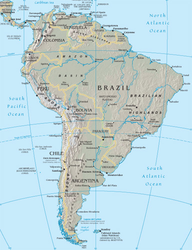
South America Google Maps
The landscape of global sovereignty has dramatically shifted over the past several decades. From just 82 sovereign states in 1950, the number has surged to almost 200 today. This rise can largely be attributed to the fervent push for national self-determination following eras of colonialism and oppression. As the world map has become increasingly dotted with more borders, international border disputes have simultaneously risen. Often fueled by religious or ethnic motivations, these newfound independences have sometimes led to intense internal conflicts, particularly with minority groups. While many nations have transitioned into independence with relative peace, adopting forms of government ranging from multiparty democracies to more centralized powers, others have experienced tumultuous power struggles, occasionally resulting in military dictatorships or individual despots. These early stages of nationhood are critical in shaping the future of emerging states.
World Route Planner offers an extensive South America gazetteer, powered by Google Maps, providing detailed Driving Directions and Google Street View across the cities of South America. Our collaboration with Google Maps delivers the most comprehensive online satellite imagery available, enhancing your exploration of South America. Our database covers thousands of locations in South America, categorized by countries, counties, administrative regions, and cities. Additionally, World Route Planner provides precise Time Zones and Daylight maps for South America. Take advantage of this wealth of information and start exploring South America with Google Maps today!
Google Maps of South America
To access Google Street View for any city in South America, simply drag the yellow pegman icon located above the zoom controls directly onto the map. This will activate the Street View feature, allowing you to explore the streets and landmarks of South America up close.
Facts of South America
Reaching from the humid tropics down into the cold South Atlantic, South America has an area of 6,886,000 sq miles (17,835,000 sq km). There are 12 separate countries, the largest of which is Brazil, which covers almost half the continent.- Greatest extent, North-South: 4750 miles / 7640 km
- Greatest extent, East-West: 3100 miles / 4990 km
- The most northerly point: Punta Gallinas, Colombia, 12° 28’ N
- Most southerly point: Cape Horn, Chile 55° 59’ S
- Lowest point: Laguna del Carbón, Argentina -344 ft (-105 m)
- Most westerly point: Galapagos Islands, Ecuador 92° W
- Most easterly point: Ilhas Martin Vaz, Brazil 28° 51’ W
- Largest lake: Lake Titicaca, Bolivia/Peru 3220 sq miles (8340 sq km)
- Highest recorded temperature: Rivadavia, Argentina 120°F (49°C)
- Lowest recorded temperature: Sarmiento, Argentina -27°F (-33°C)
- Highest point: Cerro Aconcagua, Argentina 22,833 ft (6959 m)
Climate
The climate of South America is influenced by three principal factors: the seasonal shift of high-pressure air masses over the tropics, cold ocean currents along the western coast, affecting temperature and precipitation, and the mountain barrier produced by the Andes, which creates a rain shadow over much of the south.Shaping the continent
South America’s active tectonic belt has been extensively folded over millions of years; landslides are still frequent in the mountains. The large river systems that erode the mountains flow across resistant shield areas, depositing sediment. Present-day glaciation affects the distinctive landscape of the far south.Political South America
Modern South America’s political boundaries originated in the territorial endeavors of explorers during the 16th century, who claimed almost the entire continent for Portugal and Spain. The Portuguese land in the east later evolved into the federal state of Brazil, while the Spanish vice-royalties eventually emerged as separate independent nation-states in the early 19th century. South America’s growing population has become increasingly urbanized, with the growth of coastal cities into large conurbations like Rio de Janeiro and Buenos Aires. In Brazil, Argentina, Chile, and Uruguay, a succession of military dictatorships has given way to fragile but strengthening democracies.Transportation
Most major road and rail routes are confined to the coastal regions by the forbidding natural barriers of the Andes mountains and the Amazon Basin. Few major cross-continental routes exist, although Buenos Aires is a transportation center for the main rail links to La Paz and Valparaíso. At the same time, the construction of the Trans-Amazon and Pan-American Highways has made direct road travel possible from Recife to Lima and from Puerto Montt up the coast into Central America. Although it involves considerable wetland destruction, a new waterway project is proposed to transform the River Paraguay into a major shipping route.Population
Almost half of South America’s population lives in Brazil. Still, due to the large uninhabited expanses of the Amazon Basin, its overall population density is much lower than in other countries. During the 20th century, the most important population trend was the movement from rural to urban areas, giving rise to great population concentrations in large cities like São Paulo, Rio de Janeiro, Caracas, Lima, Bogotá, and Buenos Aires.Languages
Prior to European exploration in the 16th century, a diverse range of indigenous languages were spoken across the continent. With the arrival of Iberian settlers, Spanish became the dominant language, with Portuguese spoken in Brazil and Native American languages such as Quechua and Guaraní, becoming concentrated in the continental interior. Today, this pattern persists, although successive European colonization has led to Dutch being spoken in Suriname, English in Guyana, and French in French Guiana. In large urban areas, Japanese and Chinese are increasingly common.South American resources
Agriculture still provides the largest single form of employment in South America. However, rural unemployment and poverty continue to drive people to the huge coastal cities in search of jobs and opportunities. Although substantial, Mineral and fuel resources are distributed unevenly; few countries have fossil fuels and minerals. To break industrial dependence on raw materials, boost manufacturing, and improve infrastructure, governments borrowed heavily from the World Bank in the 1960s and 1970s. This led to the accumulation of massive debts, which are unlikely ever to be repaid. Today, Brazil dominates the continent’s economic output, followed by Argentina. Recently, the less-developed western side of South America has benefited due to its geographical position; for example, Chile is increasingly exporting raw materials to Japan.Standard of living
Wealth disparities throughout the continent create a wide gulf between affluent landowners and those afflicted by chronic poverty in inner-city slums. The illicit production of cocaine and the hugely influential drug barons who control its distribution contribute to the violent disorder and corruption that affect northwestern South America, destabilizing local governments and economies.Industry
Argentina and Brazil are South America’s most industrialized countries, and São Paulo is the continent’s leading industrial center. Long-term government investment in Brazilian industry has encouraged a diverse industrial base; engineering, steel production, food processing, textile manufacture, and chemicals predominate. The illegal production of cocaine is economically significant in the Andean countries of Colombia and Bolivia. In Venezuela, the oil-dominated economy has left the country vulnerable to world oil price fluctuations. Food processing and mineral exploitation are common throughout the less industrially developed parts of the continent, including Bolivia, Chile, Ecuador, and Peru.Environmental issues
The Amazon Basin is one of Earth's last great wilderness areas. The tropical rain forests that grow there are a valuable genetic resource, containing innumerable unique plants and animals. The forests are increasingly threatened by new and expanding settlements and “slash-and-burn” farming techniques, which clear land for raising beef cattle, causing land degradation and soil erosion.Using the land and sea
Many foods now common worldwide originated in South America. These include the potato, tomato, squash, and cassava. Today, large herds of beef cattle roam the temperate grasslands of the Pampas, supporting an extensive meatpacking trade in Argentina, Uruguay, and Paraguay. Corn is grown as a staple crop across the continent, and coffee is grown as a cash crop in Brazil and Colombia. Coca plants grown in Bolivia, Peru, and Colombia provide most of the world’s cocaine. Fish and shellfish are caught off the western coast, especially anchovies off Peru, shrimps off Ecuador, and pilchards off Chile.Mineral resources
Over a quarter of the world’s known copper reserves are found at the Chuquicamata mine in northern Chile, and other metallic minerals, such as tin, are found along the length of the Andes. The discovery of oil and gas at Venezuela’s Lake Maracaibo in 1917 turned the country into one of the world’s leading oil producers. In contrast, South America is virtually devoid of coal, the only significant deposit being on the peninsula of Guajira in Colombia.Countries in South America with Google Maps and Gazetteers
Browse the most comprehensive and up-to-date online directory of countries and administrative regions in South America. Our listings are sorted alphabetically from level 1 to level 2 and up to level 3 regions, ensuring you can easily find specific locations. Integrated with Google Maps and Driving Directions, we provide all the necessary tools to explore South America. Don't wait—start exploring the unique regions and beautiful countries of South America today.
The Nature of Politics
Democracy encompasses a wide spectrum of governance practices. In its most robust form, it involves multiparty elections and fair representation. However, in some contexts, such as in Singapore, what is termed democracy can closely resemble single-party rule, where alternative political competition is limited. Conversely, in despotic regimes, power is consolidated in the hands of a single authority, often ruling through personal decree rather than through democratic processes. In such systems, institutions like the parliament and the military typically function as extensions of the dictator's will, rather than as independent entities serving the public.
The Changing World Map
As of 1950, extensive regions globally remained under the dominion of a few European countries. The decolonization process began in Asia post-World War II, where countries in southern and southeastern Asia pursued and achieved self-determination. By the 1960s, numerous African states had gained independence, significantly reducing the scope of European overseas empires by 1965. The final major phase of decolonization occurred with the dissolution of the Soviet Union and the Eastern bloc after 1990. Today, the decolonization process persists as the remaining vestiges of European colonialism, often small island nations, increasingly advocate for independence.
International boundary determinations can be based on various criteria. Borders of older states often follow natural features; others reflect religious and ethnic divides; some are remnants of complicated histories of conflict and colonialism, while others result from international agreements or arbitration.
Post-colonial borders
As European colonial empires in Africa were dismantled in the latter half of the 20th century, the resulting African state borders often replicated the colonial lines. These were drawn by colonial administrators who frequently lacked adequate geographical knowledge, leading to arbitrary divisions among people of different languages, races, religions, and customs. This confused legacy has often resulted in civil and international conflicts.
Physical borders
Many of the world's countries are delineated by physical borders such as lakes, rivers, and mountains. However, demarcating these boundaries can lead to disputes over the control of waterways, water resources, and fisheries, which are common causes of international contention.
International disputes
Today, there are over 60 disputed borders or territories globally. While many of these disputes may be resolved through peaceful negotiations, certain areas have become focal points for international conflicts. Ethnic tensions and the quest for valuable natural resources have historically been significant sources of territorial disputes. The turmoil experienced in parts of Africa during the postcolonial era is partly due to the 19th-century division of the continent, which sowed seeds of conflict by imposing often arbitrary boundaries across linguistic and cultural zones.
Link to South America Google Maps Page:
Explore our comprehensive map of South America, which has been viewed 87791 times to date. If you're interested in integrating our South America map into your website, we offer a seamless method for doing so. Our map includes valuable features such as free Google Maps access, Gazetteer Search, detailed maps of countries and cities, Street View, Driving Directions, and key facts about South America. Simply copy and paste the HTML code provided below into your website to enhance it with our detailed mapping tools. We appreciate your support and links to World Route Planner!
| Text link to: South America map and facts page |
This South America map is provided for informational purposes only. No guarantees are made regarding its accuracy or completeness. Users assume all risks associated with the use of Google Maps and Google Driving Directions. World Route Planner is not responsible for any loss or delays that may occur as a result of using this free South America map.