 Union of Burma Google Maps and Facts
Welcome to the Google Maps of Burma (MM) and the comprehensive location list for this country. World Route Planner, together with its detailed Burma page, turns Google Maps Sightseeing into a meaningful experience! Our extensive destination gazetteer, coupled with Driving Directions to Burma, allows you to explore Burma through detailed satellite imagery and street views—fast, free, and easier than ever before.
Browse through the list of administrative regions in Burma, navigate through these regions to find a place of interest, and book your hotel with the Best Price Guarantee! Your journey through Burma via Google Satellite Map Sightseeing and Street View starts here.
Burma Google Maps
To activate Street View on any city of Burma, drag above the Zoom feature the yellow little man in the map.
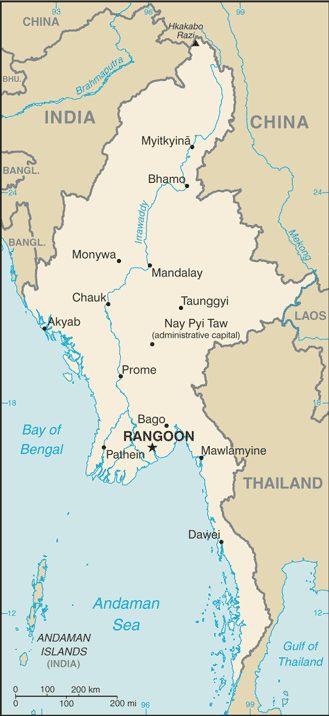
Myanmar, or Burma as it was earlier known, is in the Indo Chinese peninsula. It is rimmed with tall mountains that surround the broad fertile valley of the Ayeyarwady River. In the early 19,h century, the British East India Company expanded to the whole of Burma. Burma became an independent nation after World War II.
Facts about Burma
| Administrative divisions: | 7 divisions (taing-myar , singular - taing) and 7 states (pyi ne-myar , singular - pyi ne) divisions: Ayeyarwady , Bago , Magway , Mandalay , Sagaing , Tanintharyi , Yangon states: Chin , Kachin , Kayah , Kayin , Mon , Rakhine , Shan |
| Area: | total: 678 ,500 sq km land: 657 ,740 sq km water: 20 ,760 sq km |
| Background: | Britain conquered Burma over a period of 62 years (1824-1886) and incorporated it into its Indian Empire. Burma was administered as a province of India until 1937 when it became a separate , self-governing colony; independence from the Commonwealth was attained in 1948. Gen. NE WIN dominated the government from 1962 to 1988 , first as military ruler , then as self-appointed president , and later as political kingpin. Despite multiparty legislative elections in 1990 that resulted in the main opposition party - the National League for Democracy (NLD) - winning a landslide victory , the ruling junta refused to hand over power. NLD leader and Nobel Peace Prize recipient AUNG SAN SUU KYI , who was under house arrest from 1989 to 1995 and 2000 to 2002 , was imprisoned in May 2003 and subsequently transferred to house arrest. After Burma's ruling junta in August 2007 unexpectedly increased fuel prices , tens of thousands of Burmese marched in protest , led by prodemocracy activists and Buddhist monks. In late September 2007 , the government brutally suppressed the protests , killing at least 13 people and arresting thousands for participating in the demonstrations. Since then , the regime has continued to raid homes and monasteries and arrest persons suspected of participating in the pro-democracy protests. The junta appointed Labor Minister AUNG KYI in October 2007 as liaison to AUNG SAN SUU KYI , who remains under house arrest and virtually incommunicado with her party and supporters. |
| Flag description: | red with a blue rectangle in the upper hoist-side corner bearing 14 , white , five-pointed stars encircling a cogwheel containing a stalk of rice; the 14 stars represent the seven administrative divisions and seven states |
| Capital: | name: Rangoon (Yangon) geographic coordinates: 16 48 N , 96 09 E time difference: UTC+6.5 (11.5 hours ahead of Washington , DC during Standard Time) note: Nay Pyi Taw is administrative capital |
| Climate: | tropical monsoon; cloudy , rainy , hot , humid summers (southwest monsoon , June to September); less cloudy , scant rainfall , mild temperatures , lower humidity during winter (northeast monsoon , December to April) |
| Currency code: | kyat (MMK) |
| Ethnic groups: | Burman 68% , Shan 9% , Karen 7% , Rakhine 4% , Chinese 3% , Indian 2% , Mon 2% , other 5% |
| Geographic coordinates: | 22 00 N , 98 00 E |
| Geography note: | strategic location near major Indian Ocean shipping lanes |
| Government type: | military junta |
| Imports partners: | China 35.9% , Thailand 20.4% , Singapore 16.5% , Malaysia 4.5% (2007) |
| Internet country code: | .mm |
| Land boundaries: | 1 ,930 km |
| Neighbouring countries: | total: 5 ,876 km border countries: Bangladesh 193 km , China 2 ,185 km , India 1 ,463 km , Laos 235 km , Thailand 1 ,800 km |
| Languages: | Burmese , minority ethnic groups have their own languages |
| Location: | Southeastern Asia , bordering the Andaman Sea and the Bay of Bengal , between Bangladesh and Thailand |
| Map references: | Southeast Asia |
| National holiday: | Independence Day , 4 January (1948); Union Day , 12 February (1947) |
| Nationality: | noun: Burmese (singular and plural) adjective: Burmese |
| Natural hazards: | destructive earthquakes and cyclones; flooding and landslides common during rainy season (June to September); periodic droughts |
| Population: | 47 ,758 ,180 note: estimates for this country take into account the effects of excess mortality due to AIDS; this can result in lower life expectancy , higher infant mortality , higher death rates , lower population growth rates , and changes in the distribution of population by age and sex than would otherwise be expected (July 2008 est.) |
| Religions: | Buddhist 89% , Christian 4% (Baptist 3% , Roman Catholic 1%) , Muslim 4% , animist 1% , other 2% |
| Terrain: | central lowlands ringed by steep , rugged highlands |
| Unemployment rate: | 5.2% (2007 est.) |
Capital of Union of Burma
Yangon (click to view Yangon map)
Places in Burma
Browse the most comprehensive and up-to-date online directory of administrative regions and Street Views in Burma. Our listings are organized alphabetically, starting from level 1 regions and progressing through to level 2 and eventually level 3 regions, ensuring you can easily navigate and find specific areas of interest.
Bago Division (2133 Google Maps locations)
Chin State (932 Google Maps locations)
Kachin State (2884 Google Maps locations)
Kayah State (705 Google Maps locations)
Kayin State (1413 Google Maps locations)
Magway Division (2245 Google Maps locations)
Mon State (657 Google Maps locations)
Rakhine State (1483 Google Maps locations)
Sagaing Division (3407 Google Maps locations)
Shan State (9604 Google Maps locations)
Tanintharyi Division (1017 Google Maps locations)
Yangon Division (1079 Google Maps locations)
Random cities in Burma
Yangon, the capital city of Burma.Wãn Ma-ho
Gwedauk
Naprawn
Nam Bawtaw
Neikbanwa
Mingalun
Thanbin
Kyonkaw
Teza
'Nbau Ga
Khayin
Sadwin East
Yawng-en
Mikwi
Konkala
Paunglaung
Thayegyun
Maungma
La-kya Dawhsè
Link to Burma Google Maps page
The map of Burma has already attracted 6924 views. If you wish to embed our comprehensive Burma map on your site, we offer an easy solution. This map includes free access to Google Maps, gazetteer search, detailed country and city maps, Street View, and essential facts, all ready to enhance your website. To use it, simply copy and paste the provided HTML code into your webpage's source code. We appreciate every link back to our Maps and Driving Directions. Thank you for your support!
| Text link to: Burma map and facts page |
This Burma map is intended solely for informational purposes. No representations or warranties are made concerning its accuracy or reliability. Users assume all risks associated with the use of Google Maps and Google Driving Directions. World Route Planner is not liable for any losses or delays that may occur from using this free Burma map.