 Grenada Google Maps and Facts
Welcome to the Google Maps of Grenada (GD) and the comprehensive location list for this country. World Route Planner, together with its detailed Grenada page, turns Google Maps Sightseeing into a meaningful experience! Our extensive destination gazetteer, coupled with Driving Directions to Grenada, allows you to explore Grenada through detailed satellite imagery and street views—fast, free, and easier than ever before.
Browse through the list of administrative regions in Grenada, navigate through these regions to find a place of interest, and book your hotel with the Best Price Guarantee! Your journey through Grenada via Google Satellite Map Sightseeing and Street View starts here.
Grenada Google Maps
To activate Street View on any city of Grenada, drag above the Zoom feature the yellow little man in the map.
Facts about Grenada
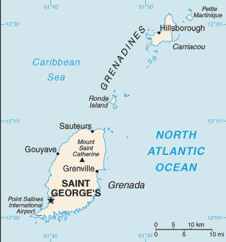
| Administrative divisions: | 6 parishes and 1 dependency*; Carriacou and Petite Martinique* , Saint Andrew , Saint David , Saint George , Saint John , Saint Mark , Saint Patrick |
| Area: | total: 344 sq km land: 344 sq km water: 0 sq km |
| Background: | Carib Indians inhabited Grenada when COLUMBUS discovered the island in 1498 , but it remained uncolonized for more than a century. The French settled Grenada in the 17th century , established sugar estates , and imported large numbers of African slaves. Britain took the island in 1762 and vigorously expanded sugar production. In the 19th century , cacao eventually surpassed sugar as the main export crop; in the 20th century , nutmeg became the leading export. In 1967 , Britain gave Grenada autonomy over its internal affairs. Full independence was attained in 1974 , making Grenada one of the smallest independent countries in the Western Hemisphere. Grenada was seized by a Marxist military council on 19 October 1983. Six days later the island was invaded by US forces and those of six other Caribbean nations , which quickly captured the ringleaders and their hundreds of Cuban advisers. Free elections were reinstituted the following year and have continued since that time. Hurricane Ivan struck Grenada in September of 2004 causing severe damage. |
| Flag description: | a rectangle divided diagonally into yellow triangles (top and bottom) and green triangles (hoist side and outer side) , with a red border around the flag; there are seven yellow , five-pointed stars with three centered in the top red border , three centered in the bottom red border , and one on a red disk superimposed at the center of the flag; there is also a symbolic nutmeg pod on the hoist-side triangle (Grenada is the world's second-largest producer of nutmeg , after Indonesia); the seven stars represent the seven administrative divisions |
| Capital: | name: Saint George's geographic coordinates: 12 03 N , 61 45 W time difference: UTC-4 (1 hour ahead of Washington , DC during Standard Time) |
| Climate: | tropical; tempered by northeast trade winds |
| Currency code: | East Caribbean dollar (XCD) |
| Ethnic groups: | black 82% , mixed black and European 13% , European and East Indian 5% , and trace of Arawak/Carib Amerindian |
| Geographic coordinates: | 12 07 N , 61 40 W |
| Geography note: | the administration of the islands of the Grenadines group is divided between Saint Vincent and the Grenadines and Grenada |
| Government type: | parliamentary democracy |
| Imports partners: | Trinidad and Tobago 35.9% , US 22.9% , Italy 4% (2007) |
| Internet country code: | .gd |
| Land boundaries: | 121 km |
| Neighbouring countries: | 0 km |
| Languages: | English (official) , French patois |
| Location: | Caribbean , island between the Caribbean Sea and Atlantic Ocean , north of Trinidad and Tobago |
| Map references: | Central America and the Caribbean |
| National holiday: | Independence Day , 7 February (1974) |
| Nationality: | noun: Grenadian(s) adjective: Grenadian |
| Natural hazards: | lies on edge of hurricane belt; hurricane season lasts from June to November |
| Population: | 90 ,343 (July 2008 est.) |
| Religions: | Roman Catholic 53% , Anglican 13.8% , other Protestant 33.2% |
| Terrain: | volcanic in origin with central mountains |
| Unemployment rate: | 12.5% (2000) |
Capital of Grenada
Saint George's (click to view Saint George's map)
Places in Grenada
Browse the most comprehensive and up-to-date online directory of administrative regions and Street Views in Grenada. Our listings are organized alphabetically, starting from level 1 regions and progressing through to level 2 and eventually level 3 regions, ensuring you can easily navigate and find specific areas of interest.
Belair city Google map
Belvedere city Google map
Bogles city Google map
Corbeau Town city Google map
Diego Piece city Google map
Dover city Google map
Dumfries city Google map
Grand Bay city Google map
Hermitage city Google map
Hillsborough city Google map
La Poterie city Google map
L'Appelle city Google map
L'Esterre city Google map
Morne Jaloux city Google map
Mount Pleasant city Google map
Plaisance Land Settlement city Google map
Pomme Rose city Google map
Saint Andrew Parish (70 google map locations)
Saint David Parish (42 google map locations)
Saint George Parish (76 google map locations)
Saint John Parish (15 google map locations)
Saint Mark Parish (9 google map locations)
Saint Patrick Parish (37 google map locations)
Six Roads city Google map
Tivoli city Google map
Windward city Google map
Random cities in Grenada
Saint George's, the capital city of Grenada.Castaigne
Mont Tout
Mount Horne
Montreuil
Sans Souci
Grenville
Harford Village
Upper La Tante
Ruth Howard
Mount Pleasant
Amber Belair
Bellevue
Saint John
Belair
Hermon
Blow Hole
White Gun
Calivigny
Paradise
Link to Grenada Google Maps page
The map of Grenada has already attracted 4652 views. If you wish to embed our comprehensive Grenada map on your site, we offer an easy solution. This map includes free access to Google Maps, gazetteer search, detailed country and city maps, Street View, and essential facts, all ready to enhance your website. To use it, simply copy and paste the provided HTML code into your webpage's source code. We appreciate every link back to our Maps and Driving Directions. Thank you for your support!
| Text link to: Grenada map and facts page |
This Grenada map is intended solely for informational purposes. No representations or warranties are made concerning its accuracy or reliability. Users assume all risks associated with the use of Google Maps and Google Driving Directions. World Route Planner is not liable for any losses or delays that may occur from using this free Grenada map.