 Republic of Bolivia Google Maps and Facts
Welcome to the Google Maps of Bolivia (BO) and the comprehensive location list for this country. World Route Planner, together with its detailed Bolivia page, turns Google Maps Sightseeing into a meaningful experience! Our extensive destination gazetteer, coupled with Driving Directions to Bolivia, allows you to explore Bolivia through detailed satellite imagery and street views—fast, free, and easier than ever before.
Browse through the list of administrative regions in Bolivia, navigate through these regions to find a place of interest, and book your hotel with the Best Price Guarantee! Your journey through Bolivia via Google Satellite Map Sightseeing and Street View starts here.
Bolivia Google Maps
To activate Street View on any city of Bolivia, drag above the Zoom feature the yellow little man in the map.
Facts about Bolivia
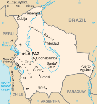
| Administrative divisions: | 9 departments (departamentos , singular - departamento); Beni , Chuquisaca , Cochabamba , La Paz , Oruro , Pando , Potosi , Santa Cruz , Tarija |
| Area: | total: 1 ,098 ,580 sq km land: 1 ,084 ,390 sq km water: 14 ,190 sq km |
| Background: | Bolivia , named after independence fighter Simon BOLIVAR , broke away from Spanish rule in 1825; much of its subsequent history has consisted of a series of nearly 200 coups and countercoups. Democratic civilian rule was established in 1982 , but leaders have faced difficult problems of deep-seated poverty , social unrest , and illegal drug production. In December 2005 , Bolivians elected Movement Toward Socialism leader Evo MORALES president - by the widest margin of any leader since the restoration of civilian rule in 1982 - after he ran on a promise to change the country's traditional political class and empower the nation's poor majority. However , since taking office , his controversial strategies have exacerbated racial and economic tensions between the Amerindian populations of the Andean west and the non-indigenous communities of the eastern lowlands. |
| Flag description: | three equal horizontal bands of red (top) , yellow , and green with the coat of arms centered on the yellow band note: similar to the flag of Ghana , which has a large black five-pointed star centered in the yellow band |
| Capital: | name: La Paz (administrative capital) geographic coordinates: 16 30 S , 68 09 W time difference: UTC-4 (1 hour ahead of Washington , DC during Standard Time) note: Sucre (constitutional capital) |
| Climate: | varies with altitude; humid and tropical to cold and semiarid |
| Currency code: | boliviano (BOB) |
| Ethnic groups: | Quechua 30% , mestizo (mixed white and Amerindian ancestry) 30% , Aymara 25% , white 15% |
| Geographic coordinates: | 17 00 S , 65 00 W |
| Geography note: | landlocked; shares control of Lago Titicaca , world's highest navigable lake (elevation 3 ,805 m) , with Peru |
| Government type: | republic |
| Imports partners: | Brazil 30% , Argentina 16.4% , Chile 10.4% , US 9.7% , Peru 8.1% (2007) |
| Internet country code: | .bo |
| Land boundaries: | 0 km (landlocked) |
| Neighbouring countries: | total: 6 ,940 km border countries: Argentina 832 km , Brazil 3 ,423 km , Chile 860 km , Paraguay 750 km , Peru 1 ,075 km |
| Languages: | Spanish 60.7% (official) , Quechua 21.2% (official) , Aymara 14.6% (official) , foreign languages 2.4% , other 1.2% (2001 census) |
| Location: | Central South America , southwest of Brazil |
| Map references: | South America |
| National holiday: | Independence Day , 6 August (1825) |
| Nationality: | noun: Bolivian(s) adjective: Bolivian |
| Natural hazards: | flooding in the northeast (March-April) |
| Population: | 9 ,247 ,816 (July 2008 est.) |
| Religions: | Roman Catholic 95% , Protestant (Evangelical Methodist) 5% |
| Terrain: | rugged Andes Mountains with a highland plateau (Altiplano) , hills , lowland plains of the Amazon Basin |
| Unemployment rate: | 7.5% in urban areas; widespread underemployment (2007 est.) |
Capital of Republic of Bolivia
Sucre (click to view Sucre map)
Places in Bolivia
Browse the most comprehensive and up-to-date online directory of administrative regions and Street Views in Bolivia. Our listings are organized alphabetically, starting from level 1 regions and progressing through to level 2 and eventually level 3 regions, ensuring you can easily navigate and find specific areas of interest.
Department of Cochabamba (579 Google Maps locations)
Department of El Beni (517 Google Maps locations)
Department of La Paz (2084 Google Maps locations)
Department of Oruro (700 Google Maps locations)
Department of Potosí (2016 Google Maps locations)
Department of Santa Cruz (1383 Google Maps locations)
Department of Tarija (566 Google Maps locations)
Random cities in Bolivia
Sucre, the capital city of Bolivia.Pequereque
Peruani
Sereré
Sidras
Pajcha
Punta León
Urrurenda
Millma Cancha
Kocha
Itarecoré
Tirina
Pacay
Achila
Pomahuico
La Manga
Chapimarca
Perrogón
Juan Bautista
Unupata
Link to Bolivia Google Maps page
The map of Bolivia has already attracted 5529 views. If you wish to embed our comprehensive Bolivia map on your site, we offer an easy solution. This map includes free access to Google Maps, gazetteer search, detailed country and city maps, Street View, and essential facts, all ready to enhance your website. To use it, simply copy and paste the provided HTML code into your webpage's source code. We appreciate every link back to our Maps and Driving Directions. Thank you for your support!
| Text link to: Bolivia map and facts page |
This Bolivia map is intended solely for informational purposes. No representations or warranties are made concerning its accuracy or reliability. Users assume all risks associated with the use of Google Maps and Google Driving Directions. World Route Planner is not liable for any losses or delays that may occur from using this free Bolivia map.