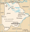
 Republic of Botswana Google Maps and Facts
Welcome to the Google Maps of Botswana (BW) and the comprehensive location list for this country. World Route Planner, together with its detailed Botswana page, turns Google Maps Sightseeing into a meaningful experience! Our extensive destination gazetteer, coupled with Driving Directions to Botswana, allows you to explore Botswana through detailed satellite imagery and street views—fast, free, and easier than ever before.
Browse through the list of administrative regions in Botswana, navigate through these regions to find a place of interest, and book your hotel with the Best Price Guarantee! Your journey through Botswana via Google Satellite Map Sightseeing and Street View starts here.
Botswana Google Maps
To activate Street View on any city of Botswana, drag above the Zoom feature the yellow little man in the map.
Facts about Botswana
| Administrative divisions: | 9 districts and 5 town councils*; Central , Francistown* , Gaborone* , Ghanzi , Jwaneng* , Kgalagadi , Kgatleng , Kweneng , Lobatse* , Northeast , Northwest , Selebi-Pikwe* , Southeast , Southern |
| Area: | total: 600 ,370 sq km land: 585 ,370 sq km water: 15 ,000 sq km Bouvet Island |
| Background: | Formerly the British protectorate of Bechuanaland , Botswana adopted its new name upon independence in 1966. Four decades of uninterrupted civilian leadership , progressive social policies , and significant capital investment have created one of the most dynamic economies in Africa. Mineral extraction , principally diamond mining , dominates economic activity , though tourism is a growing sector due to the country's conservation practices and extensive nature preserves. Botswana has one of the world's highest known rates of HIV/AIDS infection , but also one of Africa's most progressive and comprehensive programs for dealing with the disease. Bouvet Island |
| Flag description: | light blue with a horizontal white-edged black stripe in the center Bouvet Island |
| Capital: | name: Gaborone geographic coordinates: 24 45 S , 25 55 E time difference: UTC+2 (7 hours ahead of Washington , DC during Standard Time) |
| Climate: | semiarid; warm winters and hot summers Bouvet Island |
| Currency code: | pula (BWP) |
| Ethnic groups: | Tswana (or Setswana) 79% , Kalanga 11% , Basarwa 3% , other , including Kgalagadi and white 7% |
| Geographic coordinates: | 22 00 S , 24 00 E Bouvet Island |
| Geography note: | landlocked; population concentrated in eastern part of the country Bouvet Island |
| Government type: | parliamentary republic |
| Imports partners: | Southern African Customs Union (SACU) 74% , EFTA 17% , Zimbabwe 4% (2006) |
| Internet country code: | .bw Bouvet Island |
| Land boundaries: | 0 km (landlocked) Bouvet Island |
| Neighbouring countries: | total: 4 ,013 km border countries: Namibia 1 ,360 km , South Africa 1 ,840 km , Zimbabwe 813 km Bouvet Island |
| Languages: | Setswana 78.2% , Kalanga 7.9% , Sekgalagadi 2.8% , English 2.1% (official) , other 8.6% , unspecified 0.4% (2001 census) |
| Location: | Southern Africa , north of South Africa Bouvet Island |
| Map references: | Africa Bouvet Island |
| National holiday: | Independence Day (Botswana Day) , 30 September (1966) |
| Nationality: | noun: Motswana (singular) , Batswana (plural) adjective: Motswana (singular) , Batswana (plural) |
| Natural hazards: | periodic droughts; seasonal August winds blow from the west , carrying sand and dust across the country , which can obscure visibility Bouvet Island |
| Population: | 1 ,842 ,323 note: estimates for this country explicitly take into account the effects of excess mortality due to AIDS; this can result in lower life expectancy , higher infant mortality , higher death rates , lower population growth rates , and changes in the distribution of population by age and sex than would otherwise be expected (July 2008 est.) Bouvet Island |
| Religions: | Christian 71.6% , Badimo 6% , other 1.4% , unspecified 0.4% , none 20.6% (2001 census) |
| Terrain: | predominantly flat to gently rolling tableland; Kalahari Desert in southwest Bouvet Island |
| Unemployment rate: | 7.5% (2007 est.) |
Capital of Republic of Botswana
Gaborone (click to view Gaborone map)
Places in Botswana
Browse the most comprehensive and up-to-date online directory of administrative regions and Street Views in Botswana. Our listings are organized alphabetically, starting from level 1 regions and progressing through to level 2 and eventually level 3 regions, ensuring you can easily navigate and find specific areas of interest.
Ghanzi District (28 google map locations)
Kgalagadi District (24 google map locations)
Kgatleng District (4 google map locations)
Kweneng District (43 google map locations)
North West District (111 google map locations)
South East District (27 google map locations)
Southern District (32 google map locations)
Random cities in Botswana
Gaborone, the capital city of Botswana.Micawber
Lokwabe
Sansake
Mokhopetsana
Tonota
Barachu
Mosveng
Pilane
Tamasane
Mutinyane
Mpechukudu
Segara
Tsuli Village
Naledi
Baines Drift
Mushu
Matlakhotse
Kuli
Matapa
Link to Botswana Google Maps page
The map of Botswana has already attracted 6651 views. If you wish to embed our comprehensive Botswana map on your site, we offer an easy solution. This map includes free access to Google Maps, gazetteer search, detailed country and city maps, Street View, and essential facts, all ready to enhance your website. To use it, simply copy and paste the provided HTML code into your webpage's source code. We appreciate every link back to our Maps and Driving Directions. Thank you for your support!
| Text link to: Botswana map and facts page |
This Botswana map is intended solely for informational purposes. No representations or warranties are made concerning its accuracy or reliability. Users assume all risks associated with the use of Google Maps and Google Driving Directions. World Route Planner is not liable for any losses or delays that may occur from using this free Botswana map.
