 Republic of Guinea Google Maps and Facts
Welcome to the Google Maps of Guinea (GN) and the comprehensive location list for this country. World Route Planner, together with its detailed Guinea page, turns Google Maps Sightseeing into a meaningful experience! Our extensive destination gazetteer, coupled with Driving Directions to Guinea, allows you to explore Guinea through detailed satellite imagery and street views—fast, free, and easier than ever before.
Browse through the list of administrative regions in Guinea, navigate through these regions to find a place of interest, and book your hotel with the Best Price Guarantee! Your journey through Guinea via Google Satellite Map Sightseeing and Street View starts here.
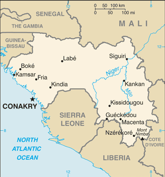
Guinea Google Maps
To activate Street View on any city of Guinea, drag above the Zoom feature the yellow little man in the map.
Facts about Guinea
| Administrative divisions: | 33 prefectures and 1 special zone (zone special)*; Beyla , Boffa , Boke , Conakry* , Coyah , Dabola , Dalaba , Dinguiraye , Dubreka , Faranah , Forecariah , Fria , Gaoual , Gueckedou , Kankan , Kerouane , Kindia , Kissidougou , Koubia , Koundara , Kouroussa , Labe , Lelouma , Lola , Macenta , Mali , Mamou , Mandiana , Nzerekore , Pita , Siguiri , Telimele , Tougue , Yomou |
| Area: | total: 245 ,857 sq km land: 245 ,857 sq km water: 0 sq km |
| Background: | Guinea has had only two presidents since gaining its independence from France in 1958. Lansana CONTE came to power in 1984 when the military seized the government after the death of the first president , Sekou TOURE. Guinea did not hold democratic elections until 1993 when Gen. CONTE (head of the military government) was elected president of the civilian government. He was reelected in 1998 and again in 2003 , though all the polls have been marred by irregularities. Guinea has maintained its internal stability despite spillover effects from conflict in Sierra Leone and Liberia. As those countries have rebuilt , Guinea's own vulnerability to political and economic crisis has increased. Declining economic conditions and popular dissatisfaction with corruption and bad governance prompted two massive strikes in 2006; a third nationwide strike in early 2007 sparked violent protests in many Guinean cities and prompted two weeks of martial law. To appease the unions and end the unrest , CONTE named a new prime minister in March 2007. |
| Flag description: | three equal vertical bands of red (hoist side) , yellow , and green; uses the popular pan-African colors of Ethiopia |
| Capital: | name: Conakry geographic coordinates: 9 33 N , 13 42 W time difference: UTC 0 (5 hours ahead of Washington , DC during Standard Time) |
| Climate: | generally hot and humid; monsoonal-type rainy season (June to November) with southwesterly winds; dry season (December to May) with northeasterly harmattan winds |
| Currency code: | Guinean franc (GNF) |
| Ethnic groups: | Peuhl 40% , Malinke 30% , Soussou 20% , smaller ethnic groups 10% |
| Geographic coordinates: | 11 00 N , 10 00 W |
| Geography note: | the Niger and its important tributary the Milo have their sources in the Guinean highlands |
| Government type: | republic |
| Imports partners: | China 10% , France 7% , Netherlands 6.3% (2007) |
| Internet country code: | .gn |
| Land boundaries: | 320 km |
| Neighbouring countries: | total: 3 ,399 km border countries: Cote d'Ivoire 610 km , Guinea-Bissau 386 km , Liberia 563 km , Mali 858 km , Senegal 330 km , Sierra Leone 652 km |
| Languages: | French (official); note - each ethnic group has its own language |
| Location: | Western Africa , bordering the North Atlantic Ocean , between Guinea-Bissau and Sierra Leone |
| Map references: | Africa |
| National holiday: | Independence Day , 2 October (1958) |
| Nationality: | noun: Guinean(s) adjective: Guinean |
| Natural hazards: | hot , dry , dusty harmattan haze may reduce visibility during dry season |
| Population: | 9 ,806 ,509 (July 2008 est.) |
| Religions: | Muslim 85% , Christian 8% , indigenous beliefs 7% |
| Terrain: | generally flat coastal plain , hilly to mountainous interior |
| Unemployment rate: | NA% |
Capital of Republic of Guinea
Conakry (click to view Conakry map)
Places in Guinea
Browse the most comprehensive and up-to-date online directory of administrative regions and Street Views in Guinea. Our listings are organized alphabetically, starting from level 1 regions and progressing through to level 2 and eventually level 3 regions, ensuring you can easily navigate and find specific areas of interest.
Boffa Prefecture (152 google map locations)
Boké Prefecture (167 google map locations)
Conakry Prefecture (45 google map locations)
Dabola Prefecture (53 google map locations)
Dalaba Prefecture (44 google map locations)
Dinguiraye Prefecture (423 google map locations)
Dubréka Prefecture (215 google map locations)
Faranah Prefecture (315 google map locations)
Forécariah Prefecture (212 google map locations)
Fria Prefecture (12 google map locations)
Gaoual Prefecture (126 google map locations)
Guékédou Prefecture (380 google map locations)
Kankan Prefecture (289 google map locations)
Kérouané Prefecture (56 google map locations)
Kindia Prefecture (171 google map locations)
Kissidougou Prefecture (417 google map locations)
Kouroussa Prefecture (272 google map locations)
Labé Prefecture (99 google map locations)
Macenta Prefecture (337 google map locations)
Mali Prefecture (291 google map locations)
Mamou Prefecture (107 google map locations)
Nzérékoré Prefecture (236 google map locations)
Pita Prefecture (70 google map locations)
Préfecture de Coyah (1 google map locations)
Préfecture de Koubia (1 google map locations)
Préfecture de Lélouma (1 google map locations)
Préfecture de Lola (1 google map locations)
Préfecture de Mandiana (1 google map locations)
Siguiri Prefecture (740 google map locations)
Télimélé Prefecture (75 google map locations)
Tougué Prefecture (65 google map locations)
Yomou Prefecture (103 google map locations)
Random cities in Guinea
Conakry, the capital city of Guinea.Sabérédougou
Kabalea
Bantala
Mandiana
Bandiraya
Bendou
Kakira
Doumba
Foual
Bowal Ila
Kémaya
Nianin
Mambiya
Fofo
Khoniya
Mountouko
Bonsoutoura
Valaïdou
Soukourala
Link to Guinea Google Maps page
The map of Guinea has already attracted 3449 views. If you wish to embed our comprehensive Guinea map on your site, we offer an easy solution. This map includes free access to Google Maps, gazetteer search, detailed country and city maps, Street View, and essential facts, all ready to enhance your website. To use it, simply copy and paste the provided HTML code into your webpage's source code. We appreciate every link back to our Maps and Driving Directions. Thank you for your support!
| Text link to: Guinea map and facts page |
This Guinea map is intended solely for informational purposes. No representations or warranties are made concerning its accuracy or reliability. Users assume all risks associated with the use of Google Maps and Google Driving Directions. World Route Planner is not liable for any losses or delays that may occur from using this free Guinea map.