 Republic of India Google Maps and Facts
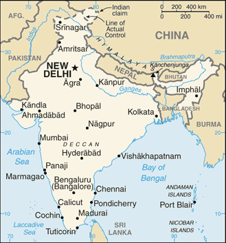
Welcome to the Google Maps of India (IN) and the comprehensive location list for this country. World Route Planner, together with its detailed India page, turns Google Maps Sightseeing into a meaningful experience! Our extensive destination gazetteer, coupled with Driving Directions to India, allows you to explore India through detailed satellite imagery and street views—fast, free, and easier than ever before.
Browse through the list of administrative regions in India, navigate through these regions to find a place of interest, and book your hotel with the Best Price Guarantee! Your journey through India via Google Satellite Map Sightseeing and Street View starts here.
For travellers, one of the most enduring impressions of India is the way everyday life is intimately intertwined with the sacred: from the housewife who devoutly performs puja (prayers) at home each morning, to the shopkeeper who – regardless of how many eager-to-buy tourists may be in the store – rarely commences business until blessings have been sought from the gods. Along with religion, family lies at the heart of Indian society. For the vast majority, the idea of being unmarried and without children by one’s mid-30s is unthinkable. Despite the rising number of nuclear families – primarily in larger cities such as Mumbai (Bombay), Bengaluru (Bangalore) and Delhi – the extended family remains a cornerstone in both urban and rural India, with males – usually the breadwinners – generally considered the head of the household.India Google Maps
To activate Street View on any city of India, drag above the Zoom feature the yellow little man in the map.
With religion and family deemed so sacrosanct, don’t be surprised or miff ed if you are grilled about these subjects yourself, especially beyond the larger cities, and receive curious (possibly disapproving) gawps if you don’t 'fit the mould'. The first question travellers are usually asked is their country of origin. This may be followed by a string of queries on topics that might be considered somewhat inappropriate elsewhere, especially coming from a complete stranger. Apart from religion and marital status, frequently asked questions include age, qualifi cations, profession (possibly even income) and your impressions of India. This is generally innocuous probing, not intended to off end. National pride has long existed on the subcontinent but has swelled in recent years as India attracts ever-increasing international kudos in various fi elds including information technology (IT), science, medicine, literature, fi lm and, of course, cricket. In the sporting arena, although there are rising stars on the tennis front, it is cricket that by far reigns supreme, with top players aff orded superhero status. The country’s robust economy – one of the world’s fastest growing – is another source of prolifi c national pride. Also widely embraced as potent symbols of Indian honour and sovereignty are the advancements in nuclear and space technology – in 2008 India joined the elite global lunar club with its maiden unmanned mission to the moon.
Why is India called the land of contrasts?
India is the world's the largest democracy, the second most populous country, and the seventh largest in terms of size. It is militarily strong, has a major cultural influence, and a fast-growing and powerful economy. It is a land of contrasts from its snow-dusted mountains to sun-washed beaches, its tranquil temples to feisty festivals, from the lantern-lit villages to software-supremo cities. There are massive mountain ranges with snowy peaks, vast plains crossed by broad rivers, parched deserts, dense tropical forests and palm fringed beaches. India is rich in natural resources, yet there is not enough food for everyone. Industry has transformed the cities, yet poverty still abounds. In fact, India has been called the rich country where poor people live! India is home to over a billion people, speaking around a thousand languages and dialects, with a large number of religions. Did you know that four of the world's religions - Hinduism, Buddhism, Jainism and Sikhism, originated in India? India is also home to one of the greatest of ancient civilizations, and has seen the rise and fall of many empires based on religion. By the 1800's, the English East India Company controlled large areas, and in 1858, India became a part of the British Empire. In 1947, India gained its independence and adopted the federal political system, whereby power is shared between the central government and 28 states.Facts about India
| Administrative divisions: | 28 states and 7 union territories*; Andaman and Nicobar Islands* , Andhra Pradesh , Arunachal Pradesh , Assam , Bihar , Chandigarh* , Chhattisgarh , Dadra and Nagar Haveli* , Daman and Diu* , Delhi* , Goa , Gujarat , Haryana , Himachal Pradesh , Jammu and Kashmir , Jharkhand , Karnataka , Kerala , Lakshadweep* , Madhya Pradesh , Maharashtra , Manipur , Meghalaya , Mizoram , Nagaland , Orissa , Puducherry* , Punjab , Rajasthan , Sikkim , Tamil Nadu , Tripura , Uttar Pradesh , Uttarakhand , West Bengal |
| Area: | total: 3 ,287 ,590 sq km land: 2 ,973 ,190 sq km water: 314 ,400 sq km Indian Ocean |
| Background: | Aryan tribes from the northwest infiltrated onto the Indian subcontinent about 1500 B.C.; their merger with the earlier Dravidian inhabitants created the classical Indian culture. The Maurya Empire of the 4th and 3rd centuries B.C. - which reached its zenith under ASHOKA - united much of South Asia. The Golden Age ushered in by the Gupta dynasty (4th to 6th centuries A.D.) saw a flowering of Indian science , art , and culture. Arab incursions starting in the 8th century and Turkic in the 12th were followed by those of European traders , beginning in the late 15th century. By the 19th century , Britain had assumed political control of virtually all Indian lands. Indian armed forces in the British army played a vital role in both World Wars. Nonviolent resistance to British colonialism led by Mohandas GANDHI and Jawaharlal NEHRU brought independence in 1947. The subcontinent was divided into the secular state of India and the smaller Muslim state of Pakistan. A third war between the two countries in 1971 resulted in East Pakistan becoming the separate nation of Bangladesh. India's nuclear weapons testing in 1998 caused Pakistan to conduct its own tests that same year. The dispute between the countries over the state of Kashmir is ongoing , but discussions and confidence-building measures have led to decreased tensions since 2002. Despite impressive gains in economic investment and output , India faces pressing problems such as significant overpopulation , environmental degradation , extensive poverty , and ethnic and religious strife. Indian Ocean |
| Flag description: | three equal horizontal bands of saffron (subdued orange) (top) , white , and green with a blue chakra (24-spoked wheel) centered in the white band; similar to the flag of Niger , which has a small orange disk centered in the white band |
| Capital: | name: New Delhi geographic coordinates: 28 36 N , 77 12 E time difference: UTC+5.5 (10.5 hours ahead of Washington , DC during Standard Time) |
| Climate: | varies from tropical monsoon in south to temperate in north Indian Ocean |
| Currency code: | Indian rupee (INR) |
| Ethnic groups: | Indo-Aryan 72% , Dravidian 25% , Mongoloid and other 3% (2000) |
| Geographic coordinates: | 20 00 N , 77 00 E Indian Ocean |
| Geography note: | dominates South Asian subcontinent; near important Indian Ocean trade routes; Kanchenjunga , third tallest mountain in the world , lies on the border with Nepal Indian Ocean |
| Government type: | federal republic |
| Imports partners: | China 10.7% , US 7.8% , Germany 4.5% , Singapore 4.4% (2007) |
| Internet country code: | .in |
| Land boundaries: | 7 ,000 km Indian Ocean |
| Neighbouring countries: | total: 14 ,103 km border countries: Bangladesh 4 ,053 km , Bhutan 605 km , Burma 1 ,463 km , China 3 ,380 km , Nepal 1 ,690 km , Pakistan 2 ,912 km |
| Languages: | Hindi 41% , Bengali 8.1% , Telugu 7.2% , Marathi 7% , Tamil 5.9% , Urdu 5% , Gujarati 4.5% , Kannada 3.7% , Malayalam 3.2% , Oriya 3.2% , Punjabi 2.8% , Assamese 1.3% , Maithili 1.2% , other 5.9% note: English enjoys associate status but is the most important language for national , political , and commercial communication; Hindi is the national language and primary tongue of 41% of the people; there are 14 other official languages: Bengali , Telugu , Marathi , Tamil , Urdu , Gujarati , Malayalam , Kannada , Oriya , Punjabi , Assamese , Kashmiri , Sindhi , and Sanskrit; Hindustani is a popular variant of Hindi/Urdu spoken widely throughout northern India but is not an official language (2001 census) |
| Location: | Southern Asia , bordering the Arabian Sea and the Bay of Bengal , between Burma and Pakistan Indian Ocean |
| Map references: | Asia Indian Ocean |
| National holiday: | Republic Day , 26 January (1950) |
| Nationality: | noun: Indian(s) adjective: Indian |
| Natural hazards: | droughts; flash floods , as well as widespread and destructive flooding from monsoonal rains; severe thunderstorms; earthquakes Indian Ocean |
| Population: | 1 ,147 ,995 ,904 (July 2008 est.) |
| Religions: | Hindu 80.5% , Muslim 13.4% , Christian 2.3% , Sikh 1.9% , other 1.8% , unspecified 0.1% (2001 census) |
| Terrain: | upland plain (Deccan Plateau) in south , flat to rolling plain along the Ganges , deserts in west , Himalayas in north Indian Ocean |
| Unemployment rate: | 7.2% (2007 est.) |
Capital of Republic of India
New Delhi (click to view New Delhi map)
Places in India
Browse the most comprehensive and up-to-date online directory of administrative regions and Street Views in India. Our listings are organized alphabetically, starting from level 1 regions and progressing through to level 2 and eventually level 3 regions, ensuring you can easily navigate and find specific areas of interest.
Adodar city Google Maps
Akarpati city Google Maps
Alorna city Google Maps
Amba city Google Maps
Ambāgarh Chauki city Google Maps
Ambeachi-Gavol city Google Maps
Ambedem city Google Maps
Āmgaon city Google Maps
Amlipadar city Google Maps
Arajkund city Google Maps
Astagal city Google Maps
Āvupalli city Google Maps
Bāgchīni city Google Maps
Bāghpat city Google Maps
Bāgrākasa city Google Maps
Baktuni city Google Maps
Balāganj city Google Maps
Baloda city Google Maps
Bandar city Google Maps
Bandavado city Google Maps
Bāndha city Google Maps
Bangabāri city Google Maps
Bankatwa city Google Maps
Bārda city Google Maps
Baregūda city Google Maps
Barjhar city Google Maps
Barki city Google Maps
Barmiāk city Google Maps
Batāoda city Google Maps
Bāvanapādu city Google Maps
Bawri city Google Maps
Be city Google Maps
Bela Muchhpakauni city Google Maps
Bethia Chhote city Google Maps
Betim city Google Maps
Bhaisālotan city Google Maps
Bhandārpur city Google Maps
Bharbharia city Google Maps
Bhariād city Google Maps
Bharkol city Google Maps
Bhasīn city Google Maps
Bhikhna Thori city Google Maps
Bhimpur city Google Maps
Bhojpur city Google Maps
Bhondia city Google Maps
Bhopālpatnam city Google Maps
Bhumria city Google Maps
Bhurtuk city Google Maps
Bihār State of (644 Google Maps locations)
Bīrpur city Google Maps
Bishanwāra city Google Maps
Bishnūpur city Google Maps
Bolegaon city Google Maps
Bolkhera city Google Maps
Boma city Google Maps
Bordi city Google Maps
Boria Tibhu city Google Maps
Bortalāo city Google Maps
Burla city Google Maps
Cancarvornem city Google Maps
Candolim city Google Maps
Caranzalem city Google Maps
Caranzol city Google Maps
Cavelossim city Google Maps
Chāchora city Google Maps
Chāmpua city Google Maps
Chāndābila city Google Maps
Chandel city Google Maps
Chāndpur city Google Maps
Changrabāndha city Google Maps
Chausāna city Google Maps
Chepzi city Google Maps
Chhamāl city Google Maps
Chhaprauli city Google Maps
Chhubakha city Google Maps
Chidām city Google Maps
Chinoni city Google Maps
Chitākhera city Google Maps
Chubha city Google Maps
Chumikteng city Google Maps
Chuntang city Google Maps
Codal city Google Maps
Colangute city Google Maps
Collem city Google Maps
Coromandel city Google Maps
Costi city Google Maps
Cotigao city Google Maps
Cumbari city Google Maps
Dabem city Google Maps
Dabhel city Google Maps
Dahikhed city Google Maps
Dalli city Google Maps
Damka city Google Maps
Damlawari city Google Maps
Damthang city Google Maps
Dangarh city Google Maps
Dariāpur city Google Maps
Daryā Ganj city Google Maps
Delwara city Google Maps
Demchok city Google Maps
Dentam city Google Maps
Deohati city Google Maps
Derodem city Google Maps
Dhanipiplia city Google Maps
Dhanpur city Google Maps
Dhānsa city Google Maps
Dharamgarh city Google Maps
Dhārāsana city Google Maps
Dharnaoda city Google Maps
Dhobe city Google Maps
Dhodhar city Google Maps
Dholera city Google Maps
Dhuwaran city Google Maps
Dikchu city Google Maps
Dolāra city Google Maps
Dolma Sampa city Google Maps
Dona Paula city Google Maps
Dongargarh city Google Maps
Donkung city Google Maps
Dumanata city Google Maps
Dwārka city Google Maps
Dzānak city Google Maps
Dzongri city Google Maps
Fatehgarh city Google Maps
Fatehpur Sīkri city Google Maps
Gangāpur city Google Maps
Gāngni city Google Maps
Ganjām city Google Maps
Garakhet city Google Maps
Garbāra city Google Maps
Garbyāng city Google Maps
Garethi city Google Maps
Geling city Google Maps
Ghogha city Google Maps
Gholvad city Google Maps
Girdi city Google Maps
Gogarpur city Google Maps
Gollapaili city Google Maps
Gotātola city Google Maps
Govindapālem city Google Maps
Gua city Google Maps
Gurla city Google Maps
Gyalshing city Google Maps
Harina city Google Maps
Hema city Google Maps
Himāchal Pradesh (608 Google Maps locations)
Himala city Google Maps
Hindu Malkot city Google Maps
Hindubāri city Google Maps
Hīr city Google Maps
Hudiāra city Google Maps
Ibrampur city Google Maps
Ichhāpur city Google Maps
Ikhlāspur city Google Maps
Ïrakam city Google Maps
Jagannāthpur city Google Maps
Jagnair city Google Maps
Jagvi city Google Maps
Jāhman city Google Maps
Jaintgarh city Google Maps
Jakthang city Google Maps
Jalangi city Google Maps
Jallo city Google Maps
Jatwāl city Google Maps
Jāwad city Google Maps
Jewar city Google Maps
Jhārkatta city Google Maps
Jīran city Google Maps
Jogbani city Google Maps
Kabalkheri city Google Maps
Kakriātalāi city Google Maps
Kalai city Google Maps
Kamar city Google Maps
Kanjeta city Google Maps
Kānsāt city Google Maps
Karīmganj city Google Maps
Kasba Mirgoda city Google Maps
Kauirik city Google Maps
Kenze Māne city Google Maps
Keran city Google Maps
Kerāng city Google Maps
Kerāninagar city Google Maps
Khairāgarh city Google Maps
Khali Kachigam city Google Maps
Khidora city Google Maps
Khowai city Google Maps
Kila city Google Maps
Kistāram city Google Maps
Kollaigūda city Google Maps
Kolūkheri city Google Maps
Konta city Google Maps
Kosamba city Google Maps
Kosi city Google Maps
Koteshvar city Google Maps
Kottūru city Google Maps
Kundanpur city Google Maps
Kuppam city Google Maps
Kushālgarh city Google Maps
Kutāna city Google Maps
Lachen city Google Maps
Lachung city Google Maps
Lakha Pharma city Google Maps
Lakshmipur city Google Maps
Lālchara city Google Maps
Lānji city Google Maps
Lankavanidibba city Google Maps
Lema city Google Maps
Lewā city Google Maps
Lingtām city Google Maps
Loltem city Google Maps
Luliāni city Google Maps
Lungthu city Google Maps
Madded city Google Maps
Magarvara city Google Maps
Magbūlpur city Google Maps
Magdala city Google Maps
Mājāli city Google Maps
Malconda city Google Maps
Malikpur city Google Maps
Mālungi city Google Maps
Mandrem city Google Maps
Māneri city Google Maps
Mangan city Google Maps
Māngrol city Google Maps
Manhiāla Kalān city Google Maps
Manhiāla Khurd city Google Maps
Manihāla city Google Maps
Mānjhītār city Google Maps
Mānpur city Google Maps
Manu city Google Maps
Matwād city Google Maps
Mavlinguem city Google Maps
Mawlashin city Google Maps
Mehegām Bangāl city Google Maps
Melli Bāzār city Google Maps
Mencurem city Google Maps
Miragwās city Google Maps
Mohala city Google Maps
Mohara city Google Maps
Morgim city Google Maps
Motumala city Google Maps
Mukabeli city Google Maps
Mul Dwārka city Google Maps
Musarat Dhulia city Google Maps
Nāchugunta city Google Maps
Nadeota city Google Maps
Nagorgao city Google Maps
Nainākot city Google Maps
Namchi city Google Maps
Nāmthāng city Google Maps
Nāndgaon city Google Maps
Nandwai city Google Maps
Naneli city Google Maps
Nanga city Google Maps
Nanodem city Google Maps
Narsinghpur city Google Maps
Nātang city Google Maps
Nātudaha city Google Maps
Naugām city Google Maps
Navāli city Google Maps
Navibandar city Google Maps
Navlakhi city Google Maps
Nawābandar city Google Maps
Nawābganj city Google Maps
Nāwāpur city Google Maps
Naya Bāzār city Google Maps
Netorlim city Google Maps
Nibia city Google Maps
Nigaria city Google Maps
Nundem city Google Maps
Orxel city Google Maps
Oxel city Google Maps
Ozorim city Google Maps
Pachi city Google Maps
Padamchen city Google Maps
Pākhriāpura city Google Maps
Pakhyong city Google Maps
Pale city Google Maps
Palli city Google Maps
Paniājob city Google Maps
Pariali city Google Maps
Pāron city Google Maps
Parsa city Google Maps
Partābpur city Google Maps
Pasewada city Google Maps
Pātan city Google Maps
Paten city Google Maps
Pechi city Google Maps
Peddapatnam city Google Maps
Pedong city Google Maps
Pemayangtse city Google Maps
Phalai city Google Maps
Phensāng city Google Maps
Phusaria city Google Maps
Pipāvāv Bandar city Google Maps
Pīplia city Google Maps
Piploda city Google Maps
Piprodā city Google Maps
Pitol city Google Maps
Podame city Google Maps
Poliem city Google Maps
Posītra city Google Maps
Potrem city Google Maps
Pujārikāker city Google Maps
Querim city Google Maps
Raghūnāthpur city Google Maps
Rāipur city Google Maps
Rāmeshwar city Google Maps
Rangli city Google Maps
Rangpo city Google Maps
Ratangarh city Google Maps
Ratanpur city Google Maps
Rhenok city Google Maps
Rinchingpong city Google Maps
Rushyābāri city Google Maps
Sābilpur city Google Maps
Sāhni city Google Maps
Sakyong city Google Maps
Salem city Google Maps
Salwānia city Google Maps
Samdong city Google Maps
Sāpria city Google Maps
Sarendhi city Google Maps
Sarwan city Google Maps
Sātpāra city Google Maps
Satpati city Google Maps
Saunk city Google Maps
Sejāwara city Google Maps
Semri city Google Maps
Shāhdara city Google Maps
Shāhpur city Google Maps
Shāmpur city Google Maps
Shāmpura city Google Maps
Shamspur city Google Maps
Shirgaon city Google Maps
Sigonem city Google Maps
Silua city Google Maps
Singhik city Google Maps
Singtam city Google Maps
Sirangulim city Google Maps
Sirsodem city Google Maps
Sirwāni city Google Maps
Sītāgaon city Google Maps
Sombāri city Google Maps
Somnāth city Google Maps
Sonaulim city Google Maps
Soreng city Google Maps
Sosing city Google Maps
Soyet city Google Maps
Sri Chhatarpur city Google Maps
State of Andhra Pradesh (2205 Google Maps locations)
State of Arunāchal Pradesh (277 Google Maps locations)
State of Assam (465 Google Maps locations)
State of Chhattīsgarh (748 Google Maps locations)
State of Goa (237 Google Maps locations)
State of Gujarāt (1243 Google Maps locations)
State of Haryāna (778 Google Maps locations)
State of Jammu and Kashmīr (3929 Google Maps locations)
State of Jharkhand (468 Google Maps locations)
State of Karnātaka (1101 Google Maps locations)
State of Kerala (311 Google Maps locations)
State of Madhya Pradesh (1635 Google Maps locations)
State of Mahārāshtra (2081 Google Maps locations)
State of Manipur (112 Google Maps locations)
State of Meghālaya (119 Google Maps locations)
State of Mizoram (124 Google Maps locations)
State of Nāgāland (86 Google Maps locations)
State of Orissa (948 Google Maps locations)
State of Punjab (481 Google Maps locations)
State of Rājasthān (2690 Google Maps locations)
State of Sikkim (1 Google Maps locations)
State of Tamil Nādu (1017 Google Maps locations)
State of Tripura (65 Google Maps locations)
State of Uttar Pradesh (1590 Google Maps locations)
State of Uttaranchal (1031 Google Maps locations)
State of West Bengal (649 Google Maps locations)
Sukhera city Google Maps
Suklatirth city Google Maps
Sundra city Google Maps
Sunphān city Google Maps
Surla city Google Maps
Sūryalanka city Google Maps
Susner city Google Maps
Sutrāpāra city Google Maps
Suvāli city Google Maps
Tādong city Google Maps
Taktsang city Google Maps
Tamze city Google Maps
Tānda city Google Maps
Tazpur city Google Maps
Tekhug city Google Maps
Temi city Google Maps
Thanggu city Google Maps
Thode city Google Maps
Thūthibāri city Google Maps
Tilāsma city Google Maps
Timarda city Google Maps
Tirkang city Google Maps
Tithal city Google Maps
Toldem city Google Maps
Toranmāl city Google Maps
Tsetang city Google Maps
Tsomgo city Google Maps
Tumlong city Google Maps
Umarkot city Google Maps
Umrat city Google Maps
Umria city Google Maps
Union Territory of Chandīgarh (1 Google Maps locations)
Union Territory of Dādra and Nagar Haveli (33 Google Maps locations)
Union Territory of Damān and Diu (11 Google Maps locations)
Union Territory of Delhi (41 Google Maps locations)
Union Territory of Lakshadweep (1 Google Maps locations)
Union Territory of Pondicherry (22 Google Maps locations)
Urmāl city Google Maps
Ustem city Google Maps
Ūsūr city Google Maps
Vadarevu city Google Maps
Valpoy city Google Maps
Varca city Google Maps
Veluz city Google Maps
Venādu city Google Maps
Vengni city Google Maps
Verlem city Google Maps
Vichondrem city Google Maps
Vihod city Google Maps
Viliena city Google Maps
Wāpi city Google Maps
Yangang city Google Maps
Yelatturdibba city Google Maps
Yume Samdong city Google Maps
Yumtang city Google Maps
Zākhung city Google Maps
Zarani city Google Maps
Random cities in India
New Delhi, the capital city of India.Silanwād
Pathradi
Lida
Kondotti
Dūdhi
Palhetar
Semra
Rāja Bhair ki Bani
Toibalawe
Rāyampālaiyam
Mānpur
Ziro
Yermarās
Khamana
Idulnāgalapalli
Karajgi
Konvāli
Paldhar
Petha Kirpālpura
Link to India Google Maps page
The map of India has already attracted 19205 views. If you wish to embed our comprehensive India map on your site, we offer an easy solution. This map includes free access to Google Maps, gazetteer search, detailed country and city maps, Street View, and essential facts, all ready to enhance your website. To use it, simply copy and paste the provided HTML code into your webpage's source code. We appreciate every link back to our Maps and Driving Directions. Thank you for your support!
| Text link to: India map and facts page |
This India map is intended solely for informational purposes. No representations or warranties are made concerning its accuracy or reliability. Users assume all risks associated with the use of Google Maps and Google Driving Directions. World Route Planner is not liable for any losses or delays that may occur from using this free India map.