 Antigua and Barbuda Google Maps and Facts
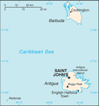
Map of Antigua and Barbuda ⇣ | Google Maps of Antigua and Barbuda ⇣ | All Places in Antigua and Barbuda ⇣
Welcome to the Google Maps of Antigua and Barbuda (AG) and the comprehensive location list for this country. World Route Planner, together with its detailed Antigua and Barbuda page, turns Google Maps Sightseeing into a meaningful experience! Our extensive destination gazetteer, coupled with Driving Directions to Antigua and Barbuda, allows you to explore Antigua and Barbuda through detailed satellite imagery and street views—fast, free, and easier than ever before.
Browse through the list of administrative regions in Antigua and Barbuda, navigate through these regions to find a place of interest, and book your hotel with the Best Price Guarantee! Your journey through Antigua and Barbuda via Google Satellite Map Sightseeing and Street View starts here.
Antigua and Barbuda Google Maps
To activate Street View on any city of Antigua and Barbuda, drag above the Zoom feature the yellow little man in the map.
Facts about Antigua and Barbuda
| Administrative divisions: | 6 parishes and 2 dependencies*; Barbuda* , Redonda* , Saint George , Saint John , Saint Mary , Saint Paul , Saint Peter , Saint Philip |
| Area: | total: 442.6 sq km (Antigua 280 sq km; Barbuda 161 sq km) land: 442.6 sq km water: 0 sq km note: includes Redonda , 1.6 sq km Arctic Ocean |
| Background: | The Siboney were the first to inhabit the islands of Antigua and Barbuda in 2400 B.C. , but Arawak Indians populated the islands when COLUMBUS landed on his second voyage in 1493. Early settlements by the Spanish and French were succeeded by the English who formed a colony in 1667. Slavery , established to run the sugar plantations on Antigua , was abolished in 1834. The islands became an independent state within the British Commonwealth of Nations in 1981. Arctic Ocean |
| Flag description: | red , with an inverted isosceles triangle based on the top edge of the flag; the triangle contains three horizontal bands of black (top) , light blue , and white , with a yellow rising sun in the black band |
| Capital: | name: Saint John's geographic coordinates: 17 07 N , 61 51 W time difference: UTC-4 (1 hour ahead of Washington , DC during Standard Time) |
| Climate: | tropical maritime; little seasonal temperature variation Arctic Ocean |
| Currency code: | East Caribbean dollar (XCD) |
| Ethnic groups: | black 91% , mixed 4.4% , white 1.7% , other 2.9% (2001 census) |
| Geographic coordinates: | 17 03 N , 61 48 W Arctic Ocean |
| Geography note: | Antigua has a deeply indented shoreline with many natural harbors and beaches; Barbuda has a large western harbor Arctic Ocean |
| Government type: | constitutional monarchy with a parliamentary system of government |
| Imports partners: | US 21.1% , China 16.4% , Germany 13.3% , Singapore 12.7% , Spain 6.5% (2006) |
| Internet country code: | .ag |
| Land boundaries: | 153 km Arctic Ocean |
| Neighbouring countries: | 0 km |
| Languages: | English (official) , local dialects |
| Location: | Caribbean , islands between the Caribbean Sea and the North Atlantic Ocean , east-southeast of Puerto Rico Arctic Ocean |
| Map references: | Central America and the Caribbean Arctic Ocean |
| National holiday: | Independence Day (National Day) , 1 November (1981) |
| Nationality: | noun: Antiguan(s) , Barbudan(s) adjective: Antiguan , Barbudan |
| Natural hazards: | hurricanes and tropical storms (July to October); periodic droughts Arctic Ocean |
| Population: | 84 ,522 (July 2008 est.) |
| Religions: | Anglican 25.7% , Seventh Day Adventist 12.3% , Pentecostal 10.6% , Moravian 10.5% , Roman Catholic 10.4% , Methodist 7.9% , Baptist 4.9% , Church of God 4.5% , other Christian 5.4% , other 2% , none or unspecified 5.8% (2001 census) |
| Terrain: | mostly low-lying limestone and coral islands , with some higher volcanic areas Arctic Ocean |
| Unemployment rate: | 11% (2001 est.) |
Capital of Antigua and Barbuda
Saint John's (click to view Saint John's map)
Places in Antigua and Barbuda
Browse the most comprehensive and up-to-date online directory of administrative regions and Street Views in Antigua and Barbuda. Our listings are organized alphabetically, starting from level 1 regions and progressing through to level 2 and eventually level 3 regions, ensuring you can easily navigate and find specific areas of interest.
Parish of Saint George (11 Google Maps locations)
Parish of Saint John (28 Google Maps locations)
Parish of Saint Mary (18 Google Maps locations)
Parish of Saint Peter (14 Google Maps locations)
Parish of Saint Philip (25 Google Maps locations)
Random cities in Antigua and Barbuda
Saint John's, the capital city of Antigua and Barbuda.Old Road
Matthews
English Harbour Town
Ffryes
Table Hill Gordon
Ebenezer
Pattersons Dwelling House
Bishops
Bolans
Cedar Grove
Hamiltons
Gaynors
Little Duers
Paynters
Crosbies
Parrys
Weatherills
Green Bay
Liberta
Link to Antigua and Barbuda Google Maps page
The map of Antigua and Barbuda has already attracted 2934 views. If you wish to embed our comprehensive Antigua and Barbuda map on your site, we offer an easy solution. This map includes free access to Google Maps, gazetteer search, detailed country and city maps, Street View, and essential facts, all ready to enhance your website. To use it, simply copy and paste the provided HTML code into your webpage's source code. We appreciate every link back to our Maps and Driving Directions. Thank you for your support!
| Text link to: Antigua and Barbuda map and facts page |
This Antigua and Barbuda map is intended solely for informational purposes. No representations or warranties are made concerning its accuracy or reliability. Users assume all risks associated with the use of Google Maps and Google Driving Directions. World Route Planner is not liable for any losses or delays that may occur from using this free Antigua and Barbuda map.