 Netherlands Antilles Google Maps and Facts
Map of Netherlands Antilles ⇣ | Google Maps of Netherlands Antilles ⇣ | All Places in Netherlands Antilles ⇣
Welcome to the Google Maps of Netherlands Antilles (AN) and the comprehensive location list for this country. World Route Planner, together with its detailed Netherlands Antilles page, turns Google Maps Sightseeing into a meaningful experience! Our extensive destination gazetteer, coupled with Driving Directions to Netherlands Antilles, allows you to explore Netherlands Antilles through detailed satellite imagery and street views—fast, free, and easier than ever before.
Browse through the list of administrative regions in Netherlands Antilles, navigate through these regions to find a place of interest, and book your hotel with the Best Price Guarantee! Your journey through Netherlands Antilles via Google Satellite Map Sightseeing and Street View starts here.
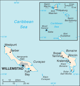
Netherlands Antilles Google Maps
To activate Street View on any city of Netherlands Antilles, drag above the Zoom feature the yellow little man in the map.
Facts about Netherlands Antilles
| Administrative divisions: | |
| Area: | |
| Background: | |
| Flag description: | |
| Capital: | |
| Climate: | |
| Currency code: | |
| Ethnic groups: | |
| Geographic coordinates: | |
| Geography note: | |
| Government type: | |
| Imports partners: | |
| Internet country code: | |
| Land boundaries: | |
| Neighbouring countries: | |
| Languages: | |
| Location: | |
| Map references: | |
| National holiday: | |
| Nationality: | |
| Natural hazards: | |
| Population: | |
| Religions: | |
| Terrain: | |
| Unemployment rate: |
Capital of Netherlands Antilles
[PLACE_CAPITAL] (click to view [PLACE_CAPITAL] map)
Places in Netherlands Antilles
Browse the most comprehensive and up-to-date online directory of administrative regions and Street Views in Netherlands Antilles. Our listings are organized alphabetically, starting from level 1 regions and progressing through to level 2 and eventually level 3 regions, ensuring you can easily navigate and find specific areas of interest.
Australie city Google map
Barber city Google map
Bel Nem city Google map
Bella Vista city Google map
Belvédère city Google map
Benesuela city Google map
Benners city Google map
Berg Altena city Google map
Blomonte city Google map
Bloomingdale city Google map
Boka Samí city Google map
Bona Vista city Google map
Bonavista city Google map
Botele city Google map
Bouille city Google map
Bou'i Seru city Google map
Boven Bolivia city Google map
Bricat city Google map
Brievengat city Google map
Buena Esperansa city Google map
Buena Vista city Google map
Buena Vista city Google map
Bullenbaai city Google map
Caranjito city Google map
Cas Corá city Google map
Chapel Piece city Google map
Cher Asile city Google map
Colon city Google map
Concordia city Google map
Cornet city Google map
Cottage Pasture city Google map
Crispeen city Google map
Cul de Sac city Google map
Cupe Coy city Google map
De Hoop city Google map
Defiance city Google map
Den Tuna city Google map
Diamond city Google map
Domi city Google map
Dominguito city Google map
Dorp Antriol city Google map
Dorp Nikiboko city Google map
Dorp Nor i Saliña city Google map
Dorp Rincón city Google map
Dorp Sabana city Google map
Dorp Sint Michiel city Google map
Dorp Sint Willebrordus city Google map
Dorp Soto city Google map
Dorp Tera Kora city Google map
Dorp Westpunt city Google map
Emmastad city Google map
English Quarter city Google map
Experiment city Google map
Fiscal city Google map
Fleur de Marie city Google map
Fontein city Google map
Fortuna Abou city Google map
Gato city Google map
Gilheads city Google map
Glass Bottle city Google map
Godet city Google map
Golden Rock city Google map
Groot Kwartier city Google map
Guatemala city Google map
Habai city Google map
Hato city Google map
Hearty city Google map
Hoop city Google map
Industrie city Google map
Ishiri city Google map
Jan Doran city Google map
Jan Doret city Google map
Janwé city Google map
Juan Domingo city Google map
Julianadorp city Google map
Kas Chikitu city Google map
Kibra Hacha city Google map
Kokorobi city Google map
Kolontjie city Google map
Koolbaai city Google map
Kortijn city Google map
Krakeel city Google map
Kralendijk city Google map
Kunchi city Google map
Kunuku Abou city Google map
Kura Juri city Google map
Kuruburu city Google map
Labra city Google map
Lagún city Google map
Leeuwarden city Google map
Libie city Google map
Lower Hell's Gate city Google map
Lower Prince's Quarter city Google map
Lower Town city Google map
Mansion city Google map
Marchena city Google map
Mari Pompun city Google map
Mary's Fancy city Google map
Mentor city Google map
Middle Region city Google map
Montan'i Rei city Google map
Motet city Google map
Mountain Piece city Google map
Mundo city Google map
Mundo Nobo city Google map
Nazareth city Google map
New Ground city Google map
Newport city Google map
Nieuw Nederland city Google map
Nobo city Google map
One Hoe city Google map
Onima city Google map
Orange Grove city Google map
Oranje Pan city Google map
Oranjestad city Google map
Orinoco city Google map
Otrabanda city Google map
Over the Pond city Google map
Para Mira city Google map
Paradijs city Google map
Paradijs city Google map
Paramira city Google map
Parera city Google map
Philipsburg city Google map
Pietermaai city Google map
Pine Garden city Google map
Porta Makaku city Google map
Porto Spaño city Google map
Prospect city Google map
Prospect Farm city Google map
Punda city Google map
Rancho city Google map
Republiek city Google map
Rigot city Google map
Riscado city Google map
Rockland city Google map
Roosendaal city Google map
Roozendaal city Google map
Rust en Vrede city Google map
Sabana Westpunt city Google map
Sabaneta city Google map
Saint John's Flat city Google map
Saint Peter city Google map
Saliña city Google map
Saliña city Google map
Saliña Abou city Google map
San Bernardo city Google map
San José city Google map
San Pedro city Google map
Santa Catarina city Google map
Santa Clara city Google map
Santa Cruz city Google map
Santa Krus city Google map
Santa Maria city Google map
Santa Rosa city Google map
Saunders city Google map
Scharloo city Google map
Schotsenhoek city Google map
Senkuria city Google map
Seritu city Google map
Ser'i Bientu city Google map
Simson Bay Village city Google map
Sint Jago city Google map
Sint Joris city Google map
Sint Jozefsdal city Google map
Sint Michiel Liber city Google map
Slangenbaai city Google map
Spring Garden city Google map
Steenrijk city Google map
Su Casa city Google map
Sucker Garden city Google map
Suffisant Dorp city Google map
Suriname Dorp city Google map
Tera Hundu city Google map
The Bottom city Google map
The Corner city Google map
The Gap city Google map
The Hope city Google map
The Level city Google map
The Villa city Google map
Trial city Google map
Union Farm city Google map
Upper Hell's Gate city Google map
Upper Prince's Quarter city Google map
Upper Town city Google map
Valentijn city Google map
Vianen city Google map
Vineyard city Google map
Vlijt city Google map
Vredeberg city Google map
Wanapa city Google map
Weis city Google map
Weitje city Google map
Welgelegen city Google map
Welgelegen city Google map
Willemstad city Google map
Wilton city Google map
Windsor city Google map
Windward Side city Google map
Wishi city Google map
Zeelandia city Google map
Random cities in Netherlands Antilles
[PLACE_CAPITAL], the capital city of Netherlands Antilles.Lower Prince's Quarter
Habai
Su Casa
Santa Maria
Experiment
Cupe Coy
Saliña
Weis
Santa Cruz
Punda
Bel Nem
Santa Clara
Gato
Dorp Sint Michiel
Rockland
Sucker Garden
Prospect Farm
Bloomingdale
Otrabanda
Link to Netherlands Antilles Google Maps page
The map of Netherlands Antilles has already attracted 2263 views. If you wish to embed our comprehensive Netherlands Antilles map on your site, we offer an easy solution. This map includes free access to Google Maps, gazetteer search, detailed country and city maps, Street View, and essential facts, all ready to enhance your website. To use it, simply copy and paste the provided HTML code into your webpage's source code. We appreciate every link back to our Maps and Driving Directions. Thank you for your support!
| Text link to: Netherlands Antilles map and facts page |
This Netherlands Antilles map is intended solely for informational purposes. No representations or warranties are made concerning its accuracy or reliability. Users assume all risks associated with the use of Google Maps and Google Driving Directions. World Route Planner is not liable for any losses or delays that may occur from using this free Netherlands Antilles map.