 Principality of Andorra Google Maps and Facts
Welcome to the Google Maps of Andorra (AD) and the comprehensive location list for this country. World Route Planner, together with its detailed Andorra page, turns Google Maps Sightseeing into a meaningful experience! Our extensive destination gazetteer, coupled with Driving Directions to Andorra, allows you to explore Andorra through detailed satellite imagery and street views—fast, free, and easier than ever before.
Browse through the list of administrative regions in Andorra, navigate through these regions to find a place of interest, and book your hotel with the Best Price Guarantee! Your journey through Andorra via Google Satellite Map Sightseeing and Street View starts here.
Andorra Google Maps
To activate Street View on any city of Andorra, drag above the Zoom feature the yellow little man in the map.
Facts about Andorra
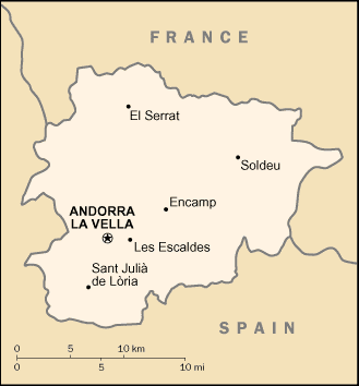
| Administrative divisions: | 7 parishes (parroquies , singular - parroquia); Andorra la Vella , Canillo , Encamp , Escaldes-Engordany , La Massana , Ordino , Sant Julia de Loria |
| Area: | total: 468 sq km land: 468 sq km water: 0 sq km |
| Background: | For 715 years , from 1278 to 1993 , Andorrans lived under a unique co-principality , ruled by French and Spanish leaders (from 1607 onward , the French chief of state and the Spanish bishop of Urgel). In 1993 , this feudal system was modified with the titular heads of state retained , but the government transformed into a parliamentary democracy. Long isolated and impoverished , mountainous Andorra achieved considerable prosperity since World War II through its tourist industry. Many immigrants (legal and illegal) are attracted to the thriving economy with its lack of income taxes. |
| Flag description: | three equal vertical bands of blue (hoist side) , yellow , and red with the national coat of arms centered in the yellow band; the coat of arms features a quartered shield note: similar to the flags of Chad and Romania , which do not have a national coat of arms in the center , and the flag of Moldova , which does bear a national emblem |
| Capital: | name: Andorra la Vella geographic coordinates: 42 30 N , 1 31 E time difference: UTC+1 (6 hours ahead of Washington , DC during Standard Time) daylight saving time: +1hr , begins last Sunday in March; ends last Sunday in October |
| Climate: | temperate; snowy , cold winters and warm , dry summers |
| Currency code: | euro (EUR) |
| Ethnic groups: | Spanish 43% , Andorran 33% , Portuguese 11% , French 7% , other 6% (1998) |
| Geographic coordinates: | 42 30 N , 1 30 E |
| Geography note: | landlocked; straddles a number of important crossroads in the Pyrenees |
| Government type: | parliamentary democracy (since March 1993) that retains as its chiefs of state a coprincipality; the two princes are the president of France and bishop of Seo de Urgel , Spain , who are represented locally by coprinces' representatives |
| Imports partners: | |
| Internet country code: | .ad |
| Land boundaries: | 0 km (landlocked) |
| Neighbouring countries: | total: 120.3 km border countries: France 56.6 km , Spain 63.7 km |
| Languages: | Catalan (official) , French , Castilian , Portuguese |
| Location: | Southwestern Europe , between France and Spain |
| Map references: | Europe |
| National holiday: | Our Lady of Meritxell Day , 8 September (1278) |
| Nationality: | noun: Andorran(s) adjective: Andorran |
| Natural hazards: | avalanches |
| Population: | 82 ,627 (July 2008 est.) |
| Religions: | Roman Catholic (predominant) |
| Terrain: | rugged mountains dissected by narrow valleys |
| Unemployment rate: | 0% (1996 est.) |
Capital of Principality of Andorra
Andorra la Vella (click to view Andorra la Vella map)
Places in Andorra
Browse the most comprehensive and up-to-date online directory of administrative regions and Street Views in Andorra. Our listings are organized alphabetically, starting from level 1 regions and progressing through to level 2 and eventually level 3 regions, ensuring you can easily navigate and find specific areas of interest.
Canillo (16 Google Maps locations)
Encamp (3 Google Maps locations)
Escaldes-Engordany (3 Google Maps locations)
Ordino (9 Google Maps locations)
Sant Julià de Lòria (12 Google Maps locations)
Random cities in Andorra
Andorra la Vella, the capital city of Andorra.El Serrat
Andorra la Vella
Aixovall
El Tremat
Segudet
Xixerella
Arinsal
Aixàs
Ansalonga
Bixessarri
Soldeu
Llorts
Pal
La Cortinada
Prats
Llumeneres
Nagol
Puiol del Piu
Aixirivall
Link to Andorra Google Maps page
The map of Andorra has already attracted 4847 views. If you wish to embed our comprehensive Andorra map on your site, we offer an easy solution. This map includes free access to Google Maps, gazetteer search, detailed country and city maps, Street View, and essential facts, all ready to enhance your website. To use it, simply copy and paste the provided HTML code into your webpage's source code. We appreciate every link back to our Maps and Driving Directions. Thank you for your support!
| Text link to: Andorra map and facts page |
This Andorra map is intended solely for informational purposes. No representations or warranties are made concerning its accuracy or reliability. Users assume all risks associated with the use of Google Maps and Google Driving Directions. World Route Planner is not liable for any losses or delays that may occur from using this free Andorra map.