 Republic of the Fiji Islands Google Maps and Facts
Welcome to the Google Maps of Fiji (FJ) and the comprehensive location list for this country. World Route Planner, together with its detailed Fiji page, turns Google Maps Sightseeing into a meaningful experience! Our extensive destination gazetteer, coupled with Driving Directions to Fiji, allows you to explore Fiji through detailed satellite imagery and street views—fast, free, and easier than ever before.
Browse through the list of administrative regions in Fiji, navigate through these regions to find a place of interest, and book your hotel with the Best Price Guarantee! Your journey through Fiji via Google Satellite Map Sightseeing and Street View starts here.
Fiji Google Maps
To activate Street View on any city of Fiji, drag above the Zoom feature the yellow little man in the map.
Facts about Fiji
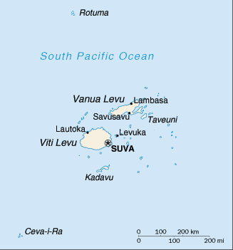
| Administrative divisions: | 4 divisions and 1 dependency*; Central , Eastern , Northern , Rotuma* , Western |
| Area: | total: 18 ,270 sq km land: 18 ,270 sq km water: 0 sq km |
| Background: | Fiji became independent in 1970 , after nearly a century as a British colony. Democratic rule was interrupted by two military coups in 1987 , caused by concern over a government perceived as dominated by the Indian community (descendants of contract laborers brought to the islands by the British in the 19th century). The coups and a 1990 constitution that cemented native Melanesian control of Fiji , led to heavy Indian emigration; the population loss resulted in economic difficulties , but ensured that Melanesians became the majority. A new constitution enacted in 1997 was more equitable. Free and peaceful elections in 1999 resulted in a government led by an Indo-Fijian , but a civilian-led coup in May 2000 ushered in a prolonged period of political turmoil. Parliamentary elections held in August 2001 provided Fiji with a democratically elected government led by Prime Minister Laisenia QARASE. Re-elected in May 2006 , QARASE was ousted in a December 2006 military coup led by Commodore Voreqe BAINIMARAMA , who initially appointed himself acting president. In January 2007 , BAINIMARAMA was appointed interim prime minister. |
| Flag description: | light blue with the flag of the UK in the upper hoist-side quadrant and the Fijian shield centered on the outer half of the flag; the shield depicts a yellow lion above a white field quartered by the cross of Saint George featuring stalks of sugarcane , a palm tree , bananas , and a white dove |
| Capital: | name: Suva (on Viti Levu) geographic coordinates: 18 08 S , 178 25 E time difference: UTC+12 (17 hours ahead of Washington , DC during Standard Time) |
| Climate: | tropical marine; only slight seasonal temperature variation |
| Currency code: | Fijian dollar (FJD) |
| Ethnic groups: | Fijian 57.3% (predominantly Melanesian with a Polynesian admixture) , Indian 37.6% , Rotuman 1.2% , other 3.9% (European , other Pacific Islanders , Chinese) (2007 census) |
| Geographic coordinates: | 18 00 S , 175 00 E |
| Geography note: | includes 332 islands; approximately 110 are inhabited |
| Government type: | republic |
| Imports partners: | Singapore 29.6% , Australia 21.6% , NZ 17.3% , China 4.4% (2007) |
| Internet country code: | .fj |
| Land boundaries: | 1 ,129 km |
| Neighbouring countries: | 0 km |
| Languages: | English (official) , Fijian (official) , Hindustani |
| Location: | Oceania , island group in the South Pacific Ocean , about two-thirds of the way from Hawaii to New Zealand |
| Map references: | Oceania |
| National holiday: | Independence Day , second Monday of October (1970) |
| Nationality: | noun: Fijian(s) adjective: Fijian |
| Natural hazards: | cyclonic storms can occur from November to January |
| Population: | 931 ,741 (July 2008 est.) |
| Religions: | Christian 53% (Methodist 34.5% , Roman Catholic 7.2% , Assembly of God 3.8% , Seventh Day Adventist 2.6% , other 4.9%) , Hindu 34% (Sanatan 25% , Arya Samaj 1.2% , other 7.8%) , Muslim 7% (Sunni 4.2%. other 2.8%) , other or unspecified 5.6% , none 0.3% (1996 census) |
| Terrain: | mostly mountains of volcanic origin |
| Unemployment rate: | 7.6% (1999) |
Capital of Republic of the Fiji Islands
Suva (click to view Suva map)
Places in Fiji
Browse the most comprehensive and up-to-date online directory of administrative regions and Street Views in Fiji. Our listings are organized alphabetically, starting from level 1 regions and progressing through to level 2 and eventually level 3 regions, ensuring you can easily navigate and find specific areas of interest.
Eastern Division (212 Google Maps locations)
Northern Division (291 Google Maps locations)
Random cities in Fiji
Suva, the capital city of Fiji.Muani
Yako
Naitutu
Ekumbu
Else'e
Lokia
Nakuku
Nasirotu
Ngaloa
Nandoli
Rairaiwangga
Vunisei
Navakawau
Vatukathevatheva
Visoto
Natuvu
Saweni
Nathavanandi
Nasukamai
Link to Fiji Google Maps page
The map of Fiji has already attracted 5358 views. If you wish to embed our comprehensive Fiji map on your site, we offer an easy solution. This map includes free access to Google Maps, gazetteer search, detailed country and city maps, Street View, and essential facts, all ready to enhance your website. To use it, simply copy and paste the provided HTML code into your webpage's source code. We appreciate every link back to our Maps and Driving Directions. Thank you for your support!
| Text link to: Fiji map and facts page |
This Fiji map is intended solely for informational purposes. No representations or warranties are made concerning its accuracy or reliability. Users assume all risks associated with the use of Google Maps and Google Driving Directions. World Route Planner is not liable for any losses or delays that may occur from using this free Fiji map.