 Federated States of Micronesia Google Maps and Facts
Map of Micronesia, Federated States of ⇣ | Google Maps of Micronesia, Federated States of ⇣ | All Places in Micronesia, Federated States of ⇣
Welcome to the Google Maps of Micronesia, Federated States of (FM) and the comprehensive location list for this country. World Route Planner, together with its detailed Micronesia, Federated States of page, turns Google Maps Sightseeing into a meaningful experience! Our extensive destination gazetteer, coupled with Driving Directions to Micronesia, Federated States of, allows you to explore Micronesia, Federated States of through detailed satellite imagery and street views—fast, free, and easier than ever before.
Browse through the list of administrative regions in Micronesia, Federated States of, navigate through these regions to find a place of interest, and book your hotel with the Best Price Guarantee! Your journey through Micronesia, Federated States of via Google Satellite Map Sightseeing and Street View starts here.
Micronesia
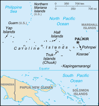
Marshall Islands , Micronesia, Nauru, Palau, Guam, Northern Mariana Islands, Wake Island. The Micronesian islands lie in the western reaches of the Pacific Ocean and are all part of the same volcanic zone. The Federated States of Micronesia is the largest group, with more than 600 atolls and forested volcanic islands in an area of more than 1120 sq miles (2900 sq km). Micronesia is a mixture of former colonies, overseas territories, and dependencies. Most of the region still relies on aid and subsidies to sustain economies limited by resources, isolation, and an emigrating population, drawn to New Zealand and Australia by the attractions of a western lifestyle.A mixture of high volcanic islands and low-lying coral atolls, the Federated States of Micronesia include all the Caroline Islands except Palau. Pohnpei, Kosrae, Chuuk, and Yap are the four main island cluster states, each of which has its own language, with English remaining the official language. Nearly half the population is concentrated on Pohnpei, the largest island. Independent since 1986, the islands continue to receive considerable aid from the US which supplements an economy based primarily on fishing and copra processing.
Micronesia, Federated States of Google Maps
To activate Street View on any city of Micronesia, Federated States of, drag above the Zoom feature the yellow little man in the map.
Palau
Palau is an archipelago of over 200 islands, only eight of which are inhabited. It was the last remaining UN trust territory in the Pacific, controlled by the US until 1994, when it became independent. The economy operates on a subsistence level, with coconuts and cassava the principal crops. Fishing licenses and tourism provide foreign currency.Guam (US)
Lying at the southern end of the Mariana Islands, Guam is an important US military base and tourist destination. Social and political life is dominated by the indigenous Chamorro, who make up just under half the population, although the increasing prevalence of western culture threatens Guam’s traditional social stability.Northern Mariana Islands (US)
A US Commonwealth territory, the Northern Marianas comprise the whole of the Mariana archipelago except for Guam. The islands retain their close links with the US and continue to receive American aid. Tourism, though bringing in much-needed revenue, has speeded the decline of the traditional subsistence economy. Most of the population lives on Saipan.Marshall Islands
A group of 34 widely-scattered atolls in the central Pacific Ocean, the Marshall Islands include some of the largest atolls in the world, formed from low coral islands with sandy beaches and enclosing vast lagoons. Formerly under US protection as part of the UN Trust Territory of the Pacific Islands, and including the former US nuclear testing sites of Bikini atoll and Enewetak Atoll, the Marshall Islands became self-governing in 1979. The economy is reliant on US aid and on the rent paid by the US for its missile base on Kwajalein atoll.Nauru
A former British colony, the tiny island of Nauru, with an area of only 8.2 sq miles (21.2 sq km), has been exploited for its substantial phosphate deposits by the UK, Australia, and New Zealand. Since independence in 1968, the phosphate industry has made its citizens some of the wealthiest in the world, and scars from the vast mining operation pit the island’s landscape. Phosphate reserves are now virtually exhausted and investment overseas will in future form the bulk of Nauru’s income.Wake Island (US)
An unincorporated territory of the US with a tiny population, Wake Island remains strategically important to US forces, and has been used as a base in several conflicts. Formed by the rim of an extinct underwater volcano, it is now used as an emergency airstrip for trans-Pacific flights, and as a stopover for cargo planes.Facts about Micronesia, Federated States of
| Administrative divisions: | 4 states; Chuuk (Truk) , Kosrae (Kosaie) , Pohnpei (Ponape) , Yap |
| Area: | total: 702 sq km land: 702 sq km water: 0 sq km (fresh water only) note: includes Pohnpei (Ponape) , Chuuk (Truk) Islands , Yap Islands , and Kosrae (Kosaie) |
| Background: | In 1979 the Federated States of Micronesia , a UN Trust Territory under US administration , adopted a constitution. In 1986 independence was attained under a Compact of Free Association with the US , which was amended and renewed in 2004. Present concerns include large-scale unemployment , overfishing , and overdependence on US aid. |
| Flag description: | light blue with four white five-pointed stars centered; the stars are arranged in a diamond pattern |
| Capital: | name: Palikir geographic coordinates: 6 55 N , 158 09 E time difference: UTC+11 (16 hours ahead of Washington , DC during Standard Time) |
| Climate: | tropical; heavy year-round rainfall , especially in the eastern islands; located on southern edge of the typhoon belt with occasionally severe damage |
| Currency code: | US dollar (USD) |
| Ethnic groups: | Chuukese 48.8% , Pohnpeian 24.2% , Kosraean 6.2% , Yapese 5.2% , Yap outer islands 4.5% , Asian 1.8% , Polynesian 1.5% , other 6.4% , unknown 1.4% (2000 census) |
| Geographic coordinates: | 6 55 N , 158 15 E |
| Geography note: | four major island groups totaling 607 islands |
| Government type: | constitutional government in free association with the US; the Compact of Free Association entered into force 3 November 1986 and the Amended Compact entered into force May 2004 |
| Imports partners: | US , Japan , Hong Kong (2006) |
| Internet country code: | .fm |
| Land boundaries: | 6 ,112 km |
| Neighbouring countries: | 0 km |
| Languages: | English (official and common language) , Chuukese , Kosrean , Pohnpeian , Yapese , Ulithian , Woleaian , Nukuoro , Kapingamarangi |
| Location: | Oceania , island group in the North Pacific Ocean , about three-quarters of the way from Hawaii to Indonesia |
| Map references: | Oceania |
| National holiday: | Constitution Day , 10 May (1979) |
| Nationality: | noun: Micronesian(s) adjective: Micronesian; Chuukese , Kosraen(s) , Pohnpeian(s) , Yapese |
| Natural hazards: | typhoons (June to December) |
| Population: | 107 ,665 (July 2008 est.) |
| Religions: | Roman Catholic 50% , Protestant 47% , other 3% |
| Terrain: | islands vary geologically from high mountainous islands to low , coral atolls; volcanic outcroppings on Pohnpei , Kosrae , and Chuuk |
| Unemployment rate: | 22% (2000 est.) |
Capital of Federated States of Micronesia
Palikir (click to view Palikir map)
Places in Micronesia, Federated States of
Browse the most comprehensive and up-to-date online directory of administrative regions and Street Views in Micronesia, Federated States of. Our listings are organized alphabetically, starting from level 1 regions and progressing through to level 2 and eventually level 3 regions, ensuring you can easily navigate and find specific areas of interest.
Random cities in Micronesia, Federated States of
Palikir, the capital city of Micronesia, Federated States of.Meseiku
Tapak
Wachngal
Weach
Talangith
Nepos
Maqweach
Paliais
Meqruur
Dechumur
Rewo
Ngoof
Kinakapw
Leang
Diadi
Taafniith
Rohnkiti
Enipoas
Sekeren Iap
Link to Micronesia, Federated States of Google Maps page
The map of Micronesia, Federated States of has already attracted 3237 views. If you wish to embed our comprehensive Micronesia, Federated States of map on your site, we offer an easy solution. This map includes free access to Google Maps, gazetteer search, detailed country and city maps, Street View, and essential facts, all ready to enhance your website. To use it, simply copy and paste the provided HTML code into your webpage's source code. We appreciate every link back to our Maps and Driving Directions. Thank you for your support!
| Text link to: Micronesia, Federated States of map and facts page |
This Micronesia, Federated States of map is intended solely for informational purposes. No representations or warranties are made concerning its accuracy or reliability. Users assume all risks associated with the use of Google Maps and Google Driving Directions. World Route Planner is not liable for any losses or delays that may occur from using this free Micronesia, Federated States of map.