 Republic of Palau Google Maps and Facts
Welcome to the Google Maps of Palau (PW) and the comprehensive location list for this country. World Route Planner, together with its detailed Palau page, turns Google Maps Sightseeing into a meaningful experience! Our extensive destination gazetteer, coupled with Driving Directions to Palau, allows you to explore Palau through detailed satellite imagery and street views—fast, free, and easier than ever before.
Browse through the list of administrative regions in Palau, navigate through these regions to find a place of interest, and book your hotel with the Best Price Guarantee! Your journey through Palau via Google Satellite Map Sightseeing and Street View starts here.
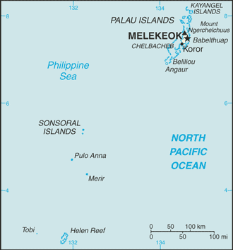
Palau Google Maps
To activate Street View on any city of Palau, drag above the Zoom feature the yellow little man in the map.
Facts about Palau
| Administrative divisions: | 16 states; Aimeliik , Airai , Angaur , Hatohobei , Kayangel , Koror , Melekeok , Ngaraard , Ngarchelong , Ngardmau , Ngatpang , Ngchesar , Ngeremlengui , Ngiwal , Peleliu , Sonsorol |
| Area: | total: 458 sq km land: 458 sq km water: 0 sq km |
| Background: | After three decades as part of the UN Trust Territory of the Pacific under US administration , this westernmost cluster of the Caroline Islands opted for independence in 1978 rather than join the Federated States of Micronesia. A Compact of Free Association with the US was approved in 1986 , but not ratified until 1993. It entered into force the following year , when the islands gained independence. |
| Flag description: | light blue with a large yellow disk (representing the moon) shifted slightly to the hoist side |
| Capital: | name: Melekeok geographic coordinates: 7 29 N , 134 38 E time difference: UTC+9 (14 hours ahead of Washington , DC during Standard Time) |
| Climate: | tropical; hot and humid; wet season May to November |
| Currency code: | US dollar (USD) |
| Ethnic groups: | Palauan (Micronesian with Malayan and Melanesian admixtures) 69.9% , Filipino 15.3% , Chinese 4.9% , other Asian 2.4% , white 1.9% , Carolinian 1.4% , other Micronesian 1.1% , other or unspecified 3.2% (2000 census) |
| Geographic coordinates: | 7 30 N , 134 30 E |
| Geography note: | westernmost archipelago in the Caroline chain , consists of six island groups totaling more than 300 islands; includes World War II battleground of Beliliou (Peleliu) and world-famous rock islands |
| Government type: | constitutional government in free association with the US; the Compact of Free Association entered into force 1 October 1994 |
| Imports partners: | US , Singapore , Japan , South Korea (2006) |
| Internet country code: | .pw |
| Land boundaries: | 1 ,519 km |
| Neighbouring countries: | 0 km |
| Languages: | Palauan 64.7% official in all islands except Sonsoral (Sonsoralese and English are official) , Tobi (Tobi and English are official) , and Angaur (Angaur , Japanese , and English are official) , Filipino 13.5% , English 9.4% , Chinese 5.7% , Carolinian 1.5% , Japanese 1.5% , other Asian 2.3% , other languages 1.5% (2000 census) |
| Location: | Oceania , group of islands in the North Pacific Ocean , southeast of the Philippines |
| Map references: | Oceania |
| National holiday: | Constitution Day , 9 July (1979) |
| Nationality: | noun: Palauan(s) adjective: Palauan |
| Natural hazards: | typhoons (June to December) |
| Population: | 21 ,093 (July 2008 est.) |
| Religions: | Roman Catholic 41.6% , Protestant 23.3% , Modekngei 8.8% (indigenous to Palau) , Seventh-Day Adventist 5.3% , Jehovah's Witness 0.9% , Latter-Day Saints 0.6% , other 3.1% , unspecified or none 16.4% (2000 census) |
| Terrain: | varying geologically from the high , mountainous main island of Babelthuap to low , coral islands usually fringed by large barrier reefs |
| Unemployment rate: | 4.2% (2005 est.) |
Capital of Republic of Palau
Koror (click to view Koror map)
Places in Palau
Browse the most comprehensive and up-to-date online directory of administrative regions and Street Views in Palau. Our listings are organized alphabetically, starting from level 1 regions and progressing through to level 2 and eventually level 3 regions, ensuring you can easily navigate and find specific areas of interest.
Akrappu city Google Maps
Almaska city Google Maps
Amoron city Google Maps
Archongelungel city Google Maps
Arkamais city Google Maps
Btangech Iterchobel city Google Maps
Btululachang ra Rrai city Google Maps
Chelab city Google Maps
Chol city Google Maps
Dabadoru city Google Maps
Dilong city Google Maps
Dimes city Google Maps
Doko city Google Maps
Echang city Google Maps
Echol city Google Maps
Eimelik city Google Maps
Eimelik city Google Maps
Elauesachel city Google Maps
Elechui city Google Maps
Ertong city Google Maps
Gabadekk city Google Maps
Gabayanga city Google Maps
Galekui city Google Maps
Geleg city Google Maps
Gelgug city Google Maps
Idid city Google Maps
Iebukel city Google Maps
Ikelau city Google Maps
Ilebei city Google Maps
Imelechol city Google Maps
Imeong city Google Maps
Imul city Google Maps
Iungel city Google Maps
Iyebukel city Google Maps
Kaemesang city Google Maps
Kamaltan city Google Maps
Kamesang city Google Maps
Kloulklubed city Google Maps
Koror city Google Maps
Lademisang city Google Maps
Madarabae city Google Maps
Mechang city Google Maps
Medalaii city Google Maps
Medorm city Google Maps
Meketii city Google Maps
Melekeok city Google Maps
Mengellang city Google Maps
Meyungs city Google Maps
Ngaramasch city Google Maps
Ngatmel city Google Maps
Ngchemesed city Google Maps
Ngchemiangel city Google Maps
Ngchesar city Google Maps
Ngchesechang city Google Maps
Ngebei city Google Maps
Ngebuked city Google Maps
Ngeburch city Google Maps
Ngemerdang city Google Maps
Ngerbau city Google Maps
Ngerbeched city Google Maps
Ngerbodel city Google Maps
Ngercheluuk city Google Maps
Ngerchemai city Google Maps
Ngerchol city Google Maps
Ngerderemang city Google Maps
Ngerekebesang city Google Maps
Ngereklmadel city Google Maps
Ngeremasech city Google Maps
Ngerkeai city Google Maps
Ngerkeseuaol city Google Maps
Ngermechau city Google Maps
Ngermelech city Google Maps
Ngermetengel city Google Maps
Ngermid city Google Maps
Ngerngesang city Google Maps
Ngersuul city Google Maps
Ngerubesang city Google Maps
Ngeruikl city Google Maps
Ngeruluobel city Google Maps
Ngerusar city Google Maps
Ngerutoi city Google Maps
Ngetbong city Google Maps
Ngetkib city Google Maps
Ngeungel city Google Maps
Ngkebeduul city Google Maps
Ngkeklau city Google Maps
Ngriil city Google Maps
Ogiil city Google Maps
Oikull city Google Maps
Olkang city Google Maps
Ollei city Google Maps
Ongeuidel city Google Maps
Orukei city Google Maps
Renrak city Google Maps
Rrai city Google Maps
Tngeronger city Google Maps
Ukurakusetsu city Google Maps
Ulimang city Google Maps
Ulutei city Google Maps
Urdmang city Google Maps
Random cities in Palau
Koror, the capital city of Palau.Mechang
Doko
Kamaltan
Chelab
Urdmang
Ngerusar
Ngchesechang
Imeong
Meketii
Ngchesar
Renrak
Ertong
Ngerkeai
Ngebei
Chol
Ngerekebesang
Geleg
Mengellang
Galekui
Link to Palau Google Maps page
The map of Palau has already attracted 3907 views. If you wish to embed our comprehensive Palau map on your site, we offer an easy solution. This map includes free access to Google Maps, gazetteer search, detailed country and city maps, Street View, and essential facts, all ready to enhance your website. To use it, simply copy and paste the provided HTML code into your webpage's source code. We appreciate every link back to our Maps and Driving Directions. Thank you for your support!
| Text link to: Palau map and facts page |
This Palau map is intended solely for informational purposes. No representations or warranties are made concerning its accuracy or reliability. Users assume all risks associated with the use of Google Maps and Google Driving Directions. World Route Planner is not liable for any losses or delays that may occur from using this free Palau map.