 Kingdom of Bhutan Google Maps and Facts
Welcome to the Google Maps of Bhutan (BT) and the comprehensive location list for this country. World Route Planner, together with its detailed Bhutan page, turns Google Maps Sightseeing into a meaningful experience! Our extensive destination gazetteer, coupled with Driving Directions to Bhutan, allows you to explore Bhutan through detailed satellite imagery and street views—fast, free, and easier than ever before.
Browse through the list of administrative regions in Bhutan, navigate through these regions to find a place of interest, and book your hotel with the Best Price Guarantee! Your journey through Bhutan via Google Satellite Map Sightseeing and Street View starts here.
Bhutan Google Maps
To activate Street View on any city of Bhutan, drag above the Zoom feature the yellow little man in the map.
Land of the Thunder
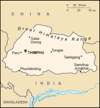
Dragon Bhután is a tiny country that is only 177 kilometres from north to south, and 321 kilometres from east to west. It nestles in the Himalayas between India and China. Almost completely cut off for centuries, it has tried to let in some aspects of the outside world while fiercely guarding its ancient traditions. The Bhutanese name for Bhutan, DrukYul, means "Land ofthe Thunder Dragon", and its flag shows a rampaging dragon.Facts about Bhutan
| Administrative divisions: | 20 districts (dzongkhag , singular and plural); Bumthang , Chhukha , Chirang , Daga , Gasa , Geylegphug , Ha , Lhuntshi , Mongar , Paro , Pemagatsel , Punakha , Samchi , Samdrup Jongkhar , Shemgang , Tashigang , Tashi Yangtse , Thimphu , Tongsa , Wangdi Phodrang |
| Area: | total: 47 ,000 sq km land: 47 ,000 sq km water: 0 sq km |
| Background: | In 1865 , Britain and Bhutan signed the Treaty of Sinchulu , under which Bhutan would receive an annual subsidy in exchange for ceding some border land to British India. Under British influence , a monarchy was set up in 1907; three years later , a treaty was signed whereby the British agreed not to interfere in Bhutanese internal affairs and Bhutan allowed Britain to direct its foreign affairs. This role was assumed by independent India after 1947. Two years later , a formal Indo-Bhutanese accord returned the areas of Bhutan annexed by the British , formalized the annual subsidies the country received , and defined India's responsibilities in defense and foreign relations. A refugee issue of over 100 ,000 Bhutanese in Nepal remains unresolved; 90% of the refugees are housed in seven United Nations Office of the High Commissioner for Refugees (UNHCR) camps. In March 2005 , King Jigme Singye WANGCHUCK unveiled the government's draft constitution - which would introduce major democratic reforms - and pledged to hold a national referendum for its approval. In December 2006 , the King abdicated the throne to his son , Jigme Khesar Namgyel WANGCHUCK , in order to give him experience as head of state before the democratic transition. In early 2007 , India and Bhutan renegotiated their treaty to allow Bhutan greater autonomy in conducting its foreign policy , although Thimphu continues to coordinate policy decisions in this area with New Delhi. In July 2007 , seven ministers of Bhutan's ten-member cabinet resigned to join the political process , and the cabinet acted as a caretaker regime until democratic elections for seats to the country's first parliament were completed in March 2008. The king ratified the country's first constitution in July 2008. |
| Flag description: | divided diagonally from the lower hoist-side corner; the upper triangle is yellow and the lower triangle is orange; centered along the dividing line is a large black and white dragon facing away from the hoist side |
| Capital: | name: Thimphu geographic coordinates: 27 29 N , 89 36 E time difference: UTC+6 (11 hours ahead of Washington , DC during Standard Time) |
| Climate: | varies; tropical in southern plains; cool winters and hot summers in central valleys; severe winters and cool summers in Himalayas |
| Currency code: | ngultrum (BTN); Indian rupee (INR) |
| Ethnic groups: | Bhote 50% , ethnic Nepalese 35% (includes Lhotsampas - one of several Nepalese ethnic groups) , indigenous or migrant tribes 15% |
| Geographic coordinates: | 27 30 N , 90 30 E |
| Geography note: | landlocked; strategic location between China and India; controls several key Himalayan mountain passes |
| Government type: | in transition to constitutional monarchy; special treaty relationship with India |
| Imports partners: | India 74.5% , Japan 7.4% , Sweden 3.2% (2007) |
| Internet country code: | .bt |
| Land boundaries: | 0 km (landlocked) |
| Neighbouring countries: | total: 1 ,075 km border countries: China 470 km , India 605 km |
| Languages: | Dzongkha (official) , Bhotes speak various Tibetan dialects , Nepalese speak various Nepalese dialects |
| Location: | Southern Asia , between China and India |
| Map references: | Asia |
| National holiday: | National Day (Ugyen WANGCHUCK became first hereditary king) , 17 December (1907) |
| Nationality: | noun: Bhutanese (singular and plural) adjective: Bhutanese |
| Natural hazards: | violent storms from the Himalayas are the source of the country's name , which translates as Land of the Thunder Dragon; frequent landslides during the rainy season |
| Population: | 682 ,321 note: the Factbook population estimate is consistent with the first modern census of Bhutan , conducted in 2005; previous Factbook population estimates for this country , which were on the order of three times the total population reported here , were based on Bhutanese government publications that did not include the census (July 2008 est.) |
| Religions: | Lamaistic Buddhist 75% , Indian- and Nepalese-influenced Hinduism 25% |
| Terrain: | mostly mountainous with some fertile valleys and savanna |
| Unemployment rate: | 2.5% (2004) |
Capital of Kingdom of Bhutan
Thimphu (click to view Thimphu map)
Places in Bhutan
Browse the most comprehensive and up-to-date online directory of administrative regions and Street Views in Bhutan. Our listings are organized alphabetically, starting from level 1 regions and progressing through to level 2 and eventually level 3 regions, ensuring you can easily navigate and find specific areas of interest.
Ama city Google Maps
Bachāp city Google Maps
Balfai city Google Maps
Bali city Google Maps
Barshong city Google Maps
Beteni city Google Maps
Bhangbārai city Google Maps
Bhurgaon city Google Maps
Bioka city Google Maps
Bitana city Google Maps
Bumtang Tang city Google Maps
Bumthang District (6 Google Maps locations)
Buri Chu city Google Maps
Byaradingka city Google Maps
Chalaika city Google Maps
Chamarchi city Google Maps
Changra city Google Maps
Chemaito city Google Maps
Chendebi city Google Maps
Chhukha District (4 Google Maps locations)
Chilo city Google Maps
Chungkar city Google Maps
Chuyul city Google Maps
Dagana District (2 Google Maps locations)
Dam city Google Maps
Daphu city Google Maps
Denchukha city Google Maps
Dhāje city Google Maps
Dhur city Google Maps
Diptsang city Google Maps
Dogsar city Google Maps
Domka city Google Maps
Donkar city Google Maps
Doring city Google Maps
Doronagaon city Google Maps
Dotanang city Google Maps
Galechugaon city Google Maps
Gasila city Google Maps
Geylegphug Dzongkhag (6 Google Maps locations)
Ghunkarah city Google Maps
Giala city Google Maps
Gnimthenla city Google Maps
Go)nphu city Google Maps
Gongchuāndgaon city Google Maps
Gyetsa city Google Maps
Haa District (3 Google Maps locations)
Harācha city Google Maps
Hlāri city Google Maps
Kagha city Google Maps
Kamganka city Google Maps
Kangpar city Google Maps
Kechungka city Google Maps
Kencho city Google Maps
Kengkhar city Google Maps
Khar city Google Maps
Khitokha city Google Maps
Kisona city Google Maps
Kungtar city Google Maps
Lāmedāda city Google Maps
Lamti city Google Maps
Lao city Google Maps
Lhuntse District (5 Google Maps locations)
Lobnig city Google Maps
Louri city Google Maps
Lung Chen city Google Maps
Manikyangsa city Google Maps
Māogaon city Google Maps
Mochhu city Google Maps
Momai Thāng city Google Maps
Mongar District (4 Google Maps locations)
Monka city Google Maps
Nab Chöte city Google Maps
Naitola city Google Maps
Namtir city Google Maps
Naspe city Google Maps
Ngālangkang city Google Maps
Niche Kālikhola city Google Maps
Nimgong city Google Maps
Ningsang La city Google Maps
Pachu city Google Maps
Pajo city Google Maps
Paro District (4 Google Maps locations)
Pemagatshel District (1 Google Maps locations)
Phisugaon city Google Maps
Pieksao city Google Maps
Pimi city Google Maps
Pinsoperi city Google Maps
Punakha District (5 Google Maps locations)
Rading city Google Maps
Raga city Google Maps
Rapley city Google Maps
Rife city Google Maps
Ritang city Google Maps
Rungzyung city Google Maps
Saidu city Google Maps
Samdrup Jongkhar District (5 Google Maps locations)
Samtengang city Google Maps
Samtse District (4 Google Maps locations)
Sana city Google Maps
Sānchi city Google Maps
Sangkari city Google Maps
Sasoka city Google Maps
Sassi city Google Maps
Sawang city Google Maps
Sawaphu city Google Maps
Sengor city Google Maps
Shabling city Google Maps
Shali city Google Maps
Shapang city Google Maps
Sharithang city Google Maps
Shegaria city Google Maps
Shingbe city Google Maps
Shingkarap city Google Maps
Shiuji city Google Maps
Shodug city Google Maps
Shuri city Google Maps
Suchha city Google Maps
Sufali city Google Maps
Tāla city Google Maps
Tamjee city Google Maps
Tamji city Google Maps
Tangsebi city Google Maps
Taripe city Google Maps
Tashi Chho Dzong city Google Maps
Tashtanje city Google Maps
Tendu city Google Maps
Thebong city Google Maps
Thimphu District (2 Google Maps locations)
Thumgaon city Google Maps
Tima city Google Maps
Tongla Kenga city Google Maps
Tosumani city Google Maps
Trashigang District (6 Google Maps locations)
Trongsa District (2 Google Maps locations)
Tsangka city Google Maps
Tse Kang city Google Maps
Tsirang District (4 Google Maps locations)
Tungka La city Google Maps
Usak city Google Maps
Wangchukling city Google Maps
Wangdue Phodrang District (3 Google Maps locations)
Yālang city Google Maps
Yuwak city Google Maps
Zarāfi city Google Maps
Zhemgang District (3 Google Maps locations)
Random cities in Bhutan
Thimphu, the capital city of Bhutan.Khitokha
Dhāje
Samtengang
Bachāp
Sana
Pachu
Pemagatsel
Daphu
Usak
Tashtanje
Donkar
Dawakha
Lao
Damthang
Ritang
Sānchi
Ningsang La
Dagapela
Go)nphu
Link to Bhutan Google Maps page
The map of Bhutan has already attracted 5820 views. If you wish to embed our comprehensive Bhutan map on your site, we offer an easy solution. This map includes free access to Google Maps, gazetteer search, detailed country and city maps, Street View, and essential facts, all ready to enhance your website. To use it, simply copy and paste the provided HTML code into your webpage's source code. We appreciate every link back to our Maps and Driving Directions. Thank you for your support!
| Text link to: Bhutan map and facts page |
This Bhutan map is intended solely for informational purposes. No representations or warranties are made concerning its accuracy or reliability. Users assume all risks associated with the use of Google Maps and Google Driving Directions. World Route Planner is not liable for any losses or delays that may occur from using this free Bhutan map.