 Belize Google Maps and Facts
Welcome to the Google Maps of Belize (BZ) and the comprehensive location list for this country. World Route Planner, together with its detailed Belize page, turns Google Maps Sightseeing into a meaningful experience! Our extensive destination gazetteer, coupled with Driving Directions to Belize, allows you to explore Belize through detailed satellite imagery and street views—fast, free, and easier than ever before.
Browse through the list of administrative regions in Belize, navigate through these regions to find a place of interest, and book your hotel with the Best Price Guarantee! Your journey through Belize via Google Satellite Map Sightseeing and Street View starts here.
Belize Google Maps
To activate Street View on any city of Belize, drag above the Zoom feature the yellow little man in the map.
Facts about Belize
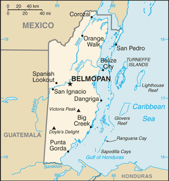
| Administrative divisions: | 6 districts; Belize , Cayo , Corozal , Orange Walk , Stann Creek , Toledo |
| Area: | total: 22 ,966 sq km land: 22 ,806 sq km water: 160 sq km |
| Background: | Belize was the site of several Mayan city states until their decline at the end of the first millennium A.D. The British and Spanish disputed the region in the 17th and 18th centuries; it formally became the colony of British Honduras in 1854. Territorial disputes between the UK and Guatemala delayed the independence of Belize until 1981. Guatemala refused to recognize the new nation until 1992. Tourism has become the mainstay of the economy. Current concerns include an unsustainable foreign debt , high unemployment , growing involvement in the South American drug trade , growing urban crime , and increasing incidences of HIV/AIDS. |
| Flag description: | blue with a narrow red stripe along the top and the bottom edges; centered is a large white disk bearing the coat of arms; the coat of arms features a shield flanked by two workers in front of a mahogany tree with the related motto SUB UMBRA FLOREO (I Flourish in the Shade) on a scroll at the bottom , all encircled by a green garland |
| Capital: | name: Belmopan geographic coordinates: 17 15 N , 88 46 W time difference: UTC-6 (1 hour behind Washington , DC during Standard Time) |
| Climate: | tropical; very hot and humid; rainy season (May to November); dry season (February to May) |
| Currency code: | Belizean dollar (BZD) |
| Ethnic groups: | mestizo 48.7% , Creole 24.9% , Maya 10.6% , Garifuna 6.1% , other 9.7% (2000 census) |
| Geographic coordinates: | 17 15 N , 88 45 W |
| Geography note: | only country in Central America without a coastline on the North Pacific Ocean |
| Government type: | parliamentary democracy |
| Imports partners: | US 30.9% , Mexico 14.2% , Cuba 8.4% , Guatemala 7.9% (2007) |
| Internet country code: | .bz |
| Land boundaries: | 386 km |
| Neighbouring countries: | total: 516 km border countries: Guatemala 266 km , Mexico 250 km |
| Languages: | Spanish 46% , Creole 32.9% , Mayan dialects 8.9% , English 3.9% (official) , Garifuna 3.4% (Carib) , German 3.3% , other 1.4% , unknown 0.2% (2000 census) |
| Location: | Central America , bordering the Caribbean Sea , between Guatemala and Mexico |
| Map references: | Central America and the Caribbean |
| National holiday: | Independence Day , 21 September (1981) |
| Nationality: | noun: Belizean(s) adjective: Belizean |
| Natural hazards: | frequent , devastating hurricanes (June to November) and coastal flooding (especially in south) |
| Population: | 301 ,270 (July 2008 est.) |
| Religions: | Roman Catholic 49.6% , Protestant 27% (Pentecostal 7.4% , Anglican 5.3% , Seventh-Day Adventist 5.2% , Mennonite 4.1% , Methodist 3.5% , Jehovah's Witnesses 1.5%) , other 14% , none 9.4% (2000) |
| Terrain: | flat , swampy coastal plain; low mountains in south |
| Unemployment rate: | 9.4% (2006) |
Capital of Belize
Belmopan (click to view Belmopan map)
Places in Belize
Browse the most comprehensive and up-to-date online directory of administrative regions and Street Views in Belize. Our listings are organized alphabetically, starting from level 1 regions and progressing through to level 2 and eventually level 3 regions, ensuring you can easily navigate and find specific areas of interest.
Cayo District (108 Google Maps locations)
Corozal District (62 Google Maps locations)
Stann Creek District (37 Google Maps locations)
Toledo District (69 Google Maps locations)
Random cities in Belize
Belmopan, the capital city of Belize.San Andres
Big Fall
Big Falls
Libertad
Cohune Ridge
Callar Creek
Esperanza
Pescado Camp
Villa Alfonso
Silver Creek
Egypt
Drill Camp
Black Man Eddy
Double Head Cabbage
Douglas
Ferguson Bank
Machaca
Blue Hole Camp
Perry Bank
Link to Belize Google Maps page
The map of Belize has already attracted 4163 views. If you wish to embed our comprehensive Belize map on your site, we offer an easy solution. This map includes free access to Google Maps, gazetteer search, detailed country and city maps, Street View, and essential facts, all ready to enhance your website. To use it, simply copy and paste the provided HTML code into your webpage's source code. We appreciate every link back to our Maps and Driving Directions. Thank you for your support!
| Text link to: Belize map and facts page |
This Belize map is intended solely for informational purposes. No representations or warranties are made concerning its accuracy or reliability. Users assume all risks associated with the use of Google Maps and Google Driving Directions. World Route Planner is not liable for any losses or delays that may occur from using this free Belize map.