 Republic of Haiti Google Maps and Facts
Welcome to the Google Maps of Haiti (HT) and the comprehensive location list for this country. World Route Planner, together with its detailed Haiti page, turns Google Maps Sightseeing into a meaningful experience! Our extensive destination gazetteer, coupled with Driving Directions to Haiti, allows you to explore Haiti through detailed satellite imagery and street views—fast, free, and easier than ever before.
Browse through the list of administrative regions in Haiti, navigate through these regions to find a place of interest, and book your hotel with the Best Price Guarantee! Your journey through Haiti via Google Satellite Map Sightseeing and Street View starts here.
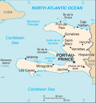
Haiti Google Maps
To activate Street View on any city of Haiti, drag above the Zoom feature the yellow little man in the map.
Facts about Haiti
| Administrative divisions: | 10 departments (departements , singular - departement); Artibonite , Centre , Grand 'Anse , Nippes , Nord , Nord-Est , Nord-Ouest , Ouest , Sud , Sud-Est |
| Area: | total: 27 ,750 sq km land: 27 ,560 sq km water: 190 sq km Heard Island and McDonald Islands |
| Background: | The native Taino Amerindians - who inhabited the island of Hispaniola when it was discovered by COLUMBUS in 1492 - were virtually annihilated by Spanish settlers within 25 years. In the early 17th century , the French established a presence on Hispaniola , and in 1697 , Spain ceded to the French the western third of the island , which later became Haiti. The French colony , based on forestry and sugar-related industries , became one of the wealthiest in the Caribbean , but only through the heavy importation of African slaves and considerable environmental degradation. In the late 18th century , Haiti's nearly half million slaves revolted under Toussaint L'OUVERTURE. After a prolonged struggle , Haiti became the first black republic to declare its independence in 1804. The poorest country in the Western Hemisphere , Haiti has been plagued by political violence for most of its history. After an armed rebellion led to the forced resignation and exile of President Jean-Bertrand ARISTIDE in February 2004 , an interim government took office to organize new elections under the auspices of the United Nations Stabilization Mission in Haiti (MINUSTAH). Continued violence and technical delays prompted repeated postponements , but Haiti finally did inaugurate a democratically elected president and parliament in May of 2006. Heard Island and McDonald Islands |
| Flag description: | two equal horizontal bands of blue (top) and red with a centered white rectangle bearing the coat of arms , which contains a palm tree flanked by flags and two cannons above a scroll bearing the motto L'UNION FAIT LA FORCE (Union Makes Strength) Heard Island and McDonald Islands |
| Capital: | name: Port-au-Prince geographic coordinates: 18 32 N , 72 20 W time difference: UTC-5 (same time as Washington , DC during Standard Time) daylight saving time: +1hr , begins first Sunday in April; ends last Sunday in October |
| Climate: | tropical; semiarid where mountains in east cut off trade winds Heard Island and McDonald Islands |
| Currency code: | gourde (HTG) |
| Ethnic groups: | black 95% , mulatto and white 5% |
| Geographic coordinates: | 19 00 N , 72 25 W Heard Island and McDonald Islands |
| Geography note: | shares island of Hispaniola with Dominican Republic (western one-third is Haiti , eastern two-thirds is the Dominican Republic) Heard Island and McDonald Islands |
| Government type: | republic |
| Imports partners: | US 41.2% , Netherlands Antilles 14.9% , Brazil 4.8% , China 4.7% (2007) |
| Internet country code: | .ht Heard Island and McDonald Islands |
| Land boundaries: | 1 ,771 km Heard Island and McDonald Islands |
| Neighbouring countries: | total: 360 km border countries: Dominican Republic 360 km Heard Island and McDonald Islands |
| Languages: | French (official) , Creole (official) |
| Location: | Caribbean , western one-third of the island of Hispaniola , between the Caribbean Sea and the North Atlantic Ocean , west of the Dominican Republic Heard Island and McDonald Islands |
| Map references: | Central America and the Caribbean Heard Island and McDonald Islands |
| National holiday: | Independence Day , 1 January (1804) |
| Nationality: | noun: Haitian(s) adjective: Haitian |
| Natural hazards: | lies in the middle of the hurricane belt and subject to severe storms from June to October; occasional flooding and earthquakes; periodic droughts Heard Island and McDonald Islands |
| Population: | 8 ,924 ,553 note: estimates for this country explicitly take into account the effects of excess mortality due to AIDS; this can result in lower life expectancy , higher infant mortality , higher death rates , lower population growth rates , and changes in the distribution of population by age and sex than would otherwise be expected (July 2008 est.) Heard Island and McDonald Islands |
| Religions: | Roman Catholic 80% , Protestant 16% (Baptist 10% , Pentecostal 4% , Adventist 1% , other 1%) , none 1% , other 3% note: roughly half of the population practices voodoo |
| Terrain: | mostly rough and mountainous Heard Island and McDonald Islands |
| Unemployment rate: | widespread unemployment and underemployment; more than two-thirds of the labor force do not have formal jobs (2002 est.) |
Capital of Republic of Haiti
Port-au-Prince (click to view Port-au-Prince map)
Places in Haiti
Browse the most comprehensive and up-to-date online directory of administrative regions and Street Views in Haiti. Our listings are organized alphabetically, starting from level 1 regions and progressing through to level 2 and eventually level 3 regions, ensuring you can easily navigate and find specific areas of interest.
Centre Department (1043 Google Maps locations)
Grand'Anse Department (1061 Google Maps locations)
North Department (1038 Google Maps locations)
North-East Department (616 Google Maps locations)
South Department (1134 Google Maps locations)
South-East Department (825 Google Maps locations)
West Department (1600 Google Maps locations)
Random cities in Haiti
Port-au-Prince, the capital city of Haiti.Fond Picard
Croix Hilaire
La Chaise
Ducrosse
Berry
Ti Bon Dieu
Gullouette
Sacristin
Étrennes
Grande Saline
Morne Jac Accé
Jabouin
Corosier
Jeantin
Baille Tourrible
Bourdet
Fond Rouge
Bossière
Daucan
Link to Haiti Google Maps page
The map of Haiti has already attracted 4535 views. If you wish to embed our comprehensive Haiti map on your site, we offer an easy solution. This map includes free access to Google Maps, gazetteer search, detailed country and city maps, Street View, and essential facts, all ready to enhance your website. To use it, simply copy and paste the provided HTML code into your webpage's source code. We appreciate every link back to our Maps and Driving Directions. Thank you for your support!
| Text link to: Haiti map and facts page |
This Haiti map is intended solely for informational purposes. No representations or warranties are made concerning its accuracy or reliability. Users assume all risks associated with the use of Google Maps and Google Driving Directions. World Route Planner is not liable for any losses or delays that may occur from using this free Haiti map.