 Saint Vincent and the Grenadines Google Maps and Facts
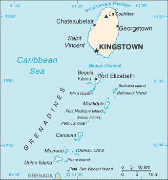
Map of Saint Vincent and the Grenadines ⇣ | Google Maps of Saint Vincent and the Grenadines ⇣ | All Places in Saint Vincent and the Grenadines ⇣
Welcome to the Google Maps of Saint Vincent and the Grenadines (VC) and the comprehensive location list for this country. World Route Planner, together with its detailed Saint Vincent and the Grenadines page, turns Google Maps Sightseeing into a meaningful experience! Our extensive destination gazetteer, coupled with Driving Directions to Saint Vincent and the Grenadines, allows you to explore Saint Vincent and the Grenadines through detailed satellite imagery and street views—fast, free, and easier than ever before.
Browse through the list of administrative regions in Saint Vincent and the Grenadines, navigate through these regions to find a place of interest, and book your hotel with the Best Price Guarantee! Your journey through Saint Vincent and the Grenadines via Google Satellite Map Sightseeing and Street View starts here.
Saint Vincent and the Grenadines Google Maps
To activate Street View on any city of Saint Vincent and the Grenadines, drag above the Zoom feature the yellow little man in the map.
Facts about Saint Vincent and the Grenadines
| Administrative divisions: | 6 parishes; Charlotte , Grenadines , Saint Andrew , Saint David , Saint George , Saint Patrick |
| Area: | total: 389 sq km (Saint Vincent 344 sq km) land: 389 sq km water: 0 sq km |
| Background: | Resistance by native Caribs prevented colonization on St. Vincent until 1719. Disputed between France and the United Kingdom for most of the 18th century , the island was ceded to the latter in 1783. Between 1960 and 1962 , Saint Vincent and the Grenadines was a separate administrative unit of the Federation of the West Indies. Autonomy was granted in 1969 and independence in 1979. |
| Flag description: | three vertical bands of blue (hoist side) , gold (double width) , and green; the gold band bears three green diamonds arranged in a V pattern |
| Capital: | name: Kingstown geographic coordinates: 13 09 N , 61 14 W time difference: UTC-4 (1 hour ahead of Washington , DC during Standard Time) |
| Climate: | tropical; little seasonal temperature variation; rainy season (May to November) |
| Currency code: | |
| Ethnic groups: | black 66% , mixed 19% , East Indian 6% , European 4% , Carib Amerindian 2% , other 3% |
| Geographic coordinates: | 13 15 N , 61 12 W |
| Geography note: | the administration of the islands of the Grenadines group is divided between Saint Vincent and the Grenadines and Grenada; Saint Vincent and the Grenadines is comprised of 32 islands and cays |
| Government type: | parliamentary democracy |
| Imports partners: | Singapore 15.2% , Trinidad and Tobago 14.3% , Italy 12.7% , US 12.5% , China 4.8% (2007) |
| Internet country code: | .vc |
| Land boundaries: | 84 km |
| Neighbouring countries: | 0 km |
| Languages: | English , French patois |
| Location: | Caribbean , islands between the Caribbean Sea and North Atlantic Ocean , north of Trinidad and Tobago |
| Map references: | Central America and the Caribbean |
| National holiday: | Independence Day , 27 October (1979) |
| Nationality: | noun: Saint Vincentian(s) or Vincentian(s) adjective: Saint Vincentian or Vincentian |
| Natural hazards: | hurricanes; Soufriere volcano on the island of Saint Vincent is a constant threat |
| Population: | 118 ,432 (July 2008 est.) |
| Religions: | Anglican 47% , Methodist 28% , Roman Catholic 13% , other (includes Hindu , Seventh-Day Adventist , other Protestant) 12% |
| Terrain: | volcanic , mountainous |
| Unemployment rate: | 15% (2001 est.) |
Capital of Saint Vincent and the Grenadines
Kingstown (click to view Kingstown map)
Places in Saint Vincent and the Grenadines
Browse the most comprehensive and up-to-date online directory of administrative regions and Street Views in Saint Vincent and the Grenadines. Our listings are organized alphabetically, starting from level 1 regions and progressing through to level 2 and eventually level 3 regions, ensuring you can easily navigate and find specific areas of interest.
Grenadines Parish (12 Google Maps locations)
Saint Andrew Parish (12 Google Maps locations)
Saint George Parish (10 Google Maps locations)
Saint Patrick Parish (5 Google Maps locations)
Random cities in Saint Vincent and the Grenadines
Kingstown, the capital city of Saint Vincent and the Grenadines.Peruvian Vale
Lovell Village
Adelphi
Bequia
Fancy
Brighton Village
Richland Park
Georgetown
Richmond Vale
Old Wall
Biabou
Richmond
Rosehall
Greiggs
Kingstown
Chateaubelair
Rabaka
Layou
Camden Park
Link to Saint Vincent and the Grenadines Google Maps page
The map of Saint Vincent and the Grenadines has already attracted 4884 views. If you wish to embed our comprehensive Saint Vincent and the Grenadines map on your site, we offer an easy solution. This map includes free access to Google Maps, gazetteer search, detailed country and city maps, Street View, and essential facts, all ready to enhance your website. To use it, simply copy and paste the provided HTML code into your webpage's source code. We appreciate every link back to our Maps and Driving Directions. Thank you for your support!
| Text link to: Saint Vincent and the Grenadines map and facts page |
This Saint Vincent and the Grenadines map is intended solely for informational purposes. No representations or warranties are made concerning its accuracy or reliability. Users assume all risks associated with the use of Google Maps and Google Driving Directions. World Route Planner is not liable for any losses or delays that may occur from using this free Saint Vincent and the Grenadines map.