 Principality of Liechtenstein Google Maps and Facts
Welcome to the Google Maps of Liechtenstein (LI) and the comprehensive location list for this country. World Route Planner, together with its detailed Liechtenstein page, turns Google Maps Sightseeing into a meaningful experience! Our extensive destination gazetteer, coupled with Driving Directions to Liechtenstein, allows you to explore Liechtenstein through detailed satellite imagery and street views—fast, free, and easier than ever before.
Browse through the list of administrative regions in Liechtenstein, navigate through these regions to find a place of interest, and book your hotel with the Best Price Guarantee! Your journey through Liechtenstein via Google Satellite Map Sightseeing and Street View starts here.
Liechtenstein Google Maps
To activate Street View on any city of Liechtenstein, drag above the Zoom feature the yellow little man in the map.
Facts about Liechtenstein
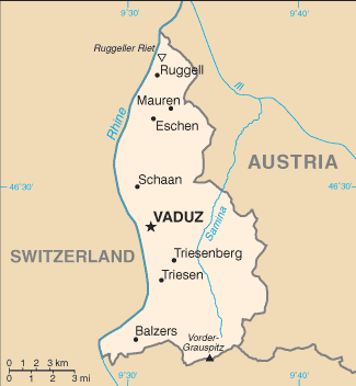
| Administrative divisions: | 11 communes (Gemeinden , singular - Gemeinde); Balzers , Eschen , Gamprin , Mauren , Planken , Ruggell , Schaan , Schellenberg , Triesen , Triesenberg , Vaduz |
| Area: | total: 160 sq km land: 160 sq km water: 0 sq km |
| Background: | The Principality of Liechtenstein was established within the Holy Roman Empire in 1719. Occupied by both French and Russian troops during the Napoleanic wars , it became a sovereign state in 1806 and joined the Germanic Confederation in 1815. Liechtenstein became fully independent in 1866 when the Confederation dissolved. Until the end of World War I , it was closely tied to Austria , but the economic devastation caused by that conflict forced Liechtenstein to enter into a customs and monetary union with Switzerland. Since World War II (in which Liechtenstein remained neutral) , the country's low taxes have spurred outstanding economic growth. In 2000 , shortcomings in banking regulatory oversight resulted in concerns about the use of financial institutions for money laundering. However , Liechtenstein implemented anti-money-laundering legislation and a Mutual Legal Assistance Treaty with the US went into effect in 2003. |
| Flag description: | two equal horizontal bands of blue (top) and red with a gold crown on the hoist side of the blue band |
| Capital: | name: Vaduz geographic coordinates: 47 08 N , 9 31 E time difference: UTC+1 (6 hours ahead of Washington , DC during Standard Time) daylight saving time: +1hr , begins last Sunday in March; ends last Sunday in October |
| Climate: | continental; cold , cloudy winters with frequent snow or rain; cool to moderately warm , cloudy , humid summers |
| Currency code: | Swiss franc (CHF) |
| Ethnic groups: | Liechtensteiner 65.6% , other 34.4% (2000 census) |
| Geographic coordinates: | 47 16 N , 9 32 E |
| Geography note: | along with Uzbekistan , one of only two doubly landlocked countries in the world; variety of microclimatic variations based on elevation |
| Government type: | constitutional monarchy |
| Imports partners: | EU , Switzerland (2006) |
| Internet country code: | .li |
| Land boundaries: | 0 km (doubly landlocked) |
| Neighbouring countries: | total: 76 km border countries: Austria 34.9 km , Switzerland 41.1 km |
| Languages: | German (official) , Alemannic dialect |
| Location: | Central Europe , between Austria and Switzerland |
| Map references: | Europe |
| National holiday: | Assumption Day , 15 August |
| Nationality: | noun: Liechtensteiner(s) adjective: Liechtenstein |
| Natural hazards: | NA |
| Population: | 34 ,498 (July 2008 est.) |
| Religions: | Roman Catholic 76.2% , Protestant 7% , unknown 10.6% , other 6.2% (June 2002) |
| Terrain: | mostly mountainous (Alps) with Rhine Valley in western third |
| Unemployment rate: | 1.3% (September 2002) |
Capital of Principality of Liechtenstein
Vaduz (click to view Vaduz map)
Places in Liechtenstein
Browse the most comprehensive and up-to-date online directory of administrative regions and Street Views in Liechtenstein. Our listings are organized alphabetically, starting from level 1 regions and progressing through to level 2 and eventually level 3 regions, ensuring you can easily navigate and find specific areas of interest.
Municipality of Eschen (2 Google Maps locations)
Municipality of Gamprin (2 Google Maps locations)
Municipality of Mauren (2 Google Maps locations)
Municipality of Planken (1 Google Maps locations)
Municipality of Ruggell (1 Google Maps locations)
Municipality of Schellenberg (4 Google Maps locations)
Municipality of Triesen (1 Google Maps locations)
Municipality of Triesenberg (7 Google Maps locations)
Municipality of Vaduz (3 Google Maps locations)
Random cities in Liechtenstein
Vaduz, the capital city of Liechtenstein.Eschen
Vaduz
Ruggell
Schaan
Vorderschellenberg
Planken
Ebenholz
Gaflei
Mäls
Triesenberg
Schellenberg
Masescha
Hinterschellenberg
Bendern
Nendeln
Schaanwald
Balzers
Sücka
Rotenboden
Link to Liechtenstein Google Maps page
The map of Liechtenstein has already attracted 5000 views. If you wish to embed our comprehensive Liechtenstein map on your site, we offer an easy solution. This map includes free access to Google Maps, gazetteer search, detailed country and city maps, Street View, and essential facts, all ready to enhance your website. To use it, simply copy and paste the provided HTML code into your webpage's source code. We appreciate every link back to our Maps and Driving Directions. Thank you for your support!
| Text link to: Liechtenstein map and facts page |
This Liechtenstein map is intended solely for informational purposes. No representations or warranties are made concerning its accuracy or reliability. Users assume all risks associated with the use of Google Maps and Google Driving Directions. World Route Planner is not liable for any losses or delays that may occur from using this free Liechtenstein map.