 Henderson, Ducie and Oeno Islands Pitcairn Google Maps and Facts
Welcome to the Google Maps of Pitcairn Islands (PN) and the comprehensive location list for this country. World Route Planner, together with its detailed Pitcairn Islands page, turns Google Maps Sightseeing into a meaningful experience! Our extensive destination gazetteer, coupled with Driving Directions to Pitcairn Islands, allows you to explore Pitcairn Islands through detailed satellite imagery and street views—fast, free, and easier than ever before.
Browse through the list of administrative regions in Pitcairn Islands, navigate through these regions to find a place of interest, and book your hotel with the Best Price Guarantee! Your journey through Pitcairn Islands via Google Satellite Map Sightseeing and Street View starts here.
Pitcairn Islands Google Maps
To activate Street View on any city of Pitcairn Islands, drag above the Zoom feature the yellow little man in the map.
Facts about Pitcairn Islands
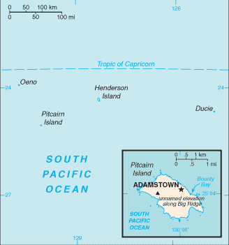
| Administrative divisions: | none (overseas territory of the UK) |
| Area: | total: 47 sq km land: 47 sq km water: 0 sq km |
| Background: | Pitcairn Island was discovered in 1767 by the British and settled in 1790 by the Bounty mutineers and their Tahitian companions. Pitcairn was the first Pacific island to become a British colony (in 1838) and today remains the last vestige of that empire in the South Pacific. Outmigration , primarily to New Zealand , has thinned the population from a peak of 233 in 1937 to less than 50 today. |
| Flag description: | blue with the flag of the UK in the upper hoist-side quadrant and the Pitcairn Islander coat of arms centered on the outer half of the flag; the coat of arms is yellow , green , and light blue with a shield featuring a yellow anchor |
| Capital: | name: Adamstown geographic coordinates: 25 04 S , 130 05 W time difference: UTC-9 (4 hours behind Washington , DC during Standard Time) |
| Climate: | tropical; hot and humid; modified by southeast trade winds; rainy season (November to March) |
| Currency code: | New Zealand dollar (NZD) |
| Ethnic groups: | descendants of the Bounty mutineers and their Tahitian wives |
| Geographic coordinates: | 25 04 S , 130 06 W |
| Geography note: | Britain's most isolated dependency; only the larger island of Pitcairn is inhabited but it has no port or natural harbor; supplies must be transported by rowed longboat from larger ships stationed offshore |
| Government type: | NA |
| Imports partners: | |
| Internet country code: | .pn |
| Land boundaries: | 51 km |
| Neighbouring countries: | 0 km |
| Languages: | English (official) , Pitkern (mixture of an 18th century English dialect and a Tahitian dialect) |
| Location: | Oceania , islands in the South Pacific Ocean , about midway between Peru and New Zealand |
| Map references: | Oceania |
| National holiday: | Birthday of Queen ELIZABETH II , second Saturday in June (1926) |
| Nationality: | noun: Pitcairn Islander(s) adjective: Pitcairn Islander |
| Natural hazards: | typhoons (especially November to March) |
| Population: | 48 (July 2008 est.) |
| Religions: | Seventh-Day Adventist 100% |
| Terrain: | rugged volcanic formation; rocky coastline with cliffs |
| Unemployment rate: |
Capital of Henderson, Ducie and Oeno Islands Pitcairn
Adamstown (click to view Adamstown map)
Places in Pitcairn Islands
Browse the most comprehensive and up-to-date online directory of administrative regions and Street Views in Pitcairn Islands. Our listings are organized alphabetically, starting from level 1 regions and progressing through to level 2 and eventually level 3 regions, ensuring you can easily navigate and find specific areas of interest.