 Republic of Peru Google Maps and Facts
Welcome to the Google Maps of Peru (PE) and the comprehensive location list for this country. World Route Planner, together with its detailed Peru page, turns Google Maps Sightseeing into a meaningful experience! Our extensive destination gazetteer, coupled with Driving Directions to Peru, allows you to explore Peru through detailed satellite imagery and street views—fast, free, and easier than ever before.
Browse through the list of administrative regions in Peru, navigate through these regions to find a place of interest, and book your hotel with the Best Price Guarantee! Your journey through Peru via Google Satellite Map Sightseeing and Street View starts here.
Peru Google Maps
To activate Street View on any city of Peru, drag above the Zoom feature the yellow little man in the map.
Facts about Peru
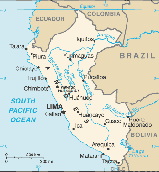
| Administrative divisions: | 25 regions (regiones , singular - region) and 1 province* (provincia); Amazonas , Ancash , Apurimac , Arequipa , Ayacucho , Cajamarca , Callao , Cusco , Huancavelica , Huanuco , Ica , Junin , La Libertad , Lambayeque , Lima , Lima* , Loreto , Madre de Dios , Moquegua , Pasco , Piura , Puno , San Martin , Tacna , Tumbes , Ucayali |
| Area: | total: 1 ,285 ,220 sq km land: 1.28 million sq km water: 5 ,220 sq km |
| Background: | Ancient Peru was the seat of several prominent Andean civilizations , most notably that of the Incas whose empire was captured by the Spanish conquistadors in 1533. Peruvian independence was declared in 1821 , and remaining Spanish forces defeated in 1824. After a dozen years of military rule , Peru returned to democratic leadership in 1980 , but experienced economic problems and the growth of a violent insurgency. President Alberto FUJIMORI's election in 1990 ushered in a decade that saw a dramatic turnaround in the economy and significant progress in curtailing guerrilla activity. Nevertheless , the president's increasing reliance on authoritarian measures and an economic slump in the late 1990s generated mounting dissatisfaction with his regime , which led to his ouster in 2000. A caretaker government oversaw new elections in the spring of 2001 , which ushered in Alejandro TOLEDO as the new head of government - Peru's first democratically elected president of Native American ethnicity. The presidential election of 2006 saw the return of Alan GARCIA who , after a disappointing presidential term from 1985 to 1990 , returned to the presidency with promises to improve social conditions and maintain fiscal responsibility. |
| Flag description: | three equal , vertical bands of red (hoist side) , white , and red with the coat of arms centered in the white band; the coat of arms features a shield bearing a vicuna , cinchona tree (the source of quinine) , and a yellow cornucopia spilling out gold coins , all framed by a green wreath |
| Capital: | name: Lima geographic coordinates: 12 03 S , 77 03 W time difference: UTC-5 (same time as Washington , DC during Standard Time) |
| Climate: | varies from tropical in east to dry desert in west; temperate to frigid in Andes |
| Currency code: | nuevo sol (PEN) |
| Ethnic groups: | Amerindian 45% , mestizo (mixed Amerindian and white) 37% , white 15% , black , Japanese , Chinese , and other 3% |
| Geographic coordinates: | 10 00 S , 76 00 W |
| Geography note: | shares control of Lago Titicaca , world's highest navigable lake , with Bolivia; a remote slope of Nevado Mismi , a 5 ,316 m peak , is the ultimate source of the Amazon River |
| Government type: | constitutional republic |
| Imports partners: | US 20.1% , China 10.6% , Brazil 9.8% , Ecuador 6% , Colombia 5.9% , Argentina 5.2% , Chile 4.9% , Mexico 4.2% (2007) |
| Internet country code: | .pe |
| Land boundaries: | 2 ,414 km |
| Neighbouring countries: | total: 7 ,461 km border countries: Bolivia 1 ,075 km , Brazil 2 ,995 km , Chile 171 km , Colombia 1 ,800 km , Ecuador 1 ,420 km |
| Languages: | Spanish (official) , Quechua (official) , Aymara , and a large number of minor Amazonian languages |
| Location: | Western South America , bordering the South Pacific Ocean , between Chile and Ecuador |
| Map references: | South America |
| National holiday: | Independence Day , 28 July (1821) |
| Nationality: | noun: Peruvian(s) adjective: Peruvian |
| Natural hazards: | earthquakes , tsunamis , flooding , landslides , mild volcanic activity |
| Population: | 29 ,180 ,900 (July 2008 est.) |
| Religions: | Roman Catholic 81% , Seventh Day Adventist 1.4% , other Christian 0.7% , other 0.6% , unspecified or none 16.3% (2003 est.) |
| Terrain: | western coastal plain (costa) , high and rugged Andes in center (sierra) , eastern lowland jungle of Amazon Basin (selva) |
| Unemployment rate: | 6.9% in metropolitan Lima; widespread underemployment (2007 est.) |
Capital of Republic of Peru
Lima (click to view Lima map)
Places in Peru
Browse the most comprehensive and up-to-date online directory of administrative regions and Street Views in Peru. Our listings are organized alphabetically, starting from level 1 regions and progressing through to level 2 and eventually level 3 regions, ensuring you can easily navigate and find specific areas of interest.
Ancash Region (425 Google Maps locations)
Apurímac Region (589 Google Maps locations)
Arequipa Region (2602 Google Maps locations)
Ayacucho Region (1015 Google Maps locations)
Cajamarca Region (920 Google Maps locations)
Callao Region (9 Google Maps locations)
Cusco Region (1498 Google Maps locations)
Huancavelica Region (301 Google Maps locations)
Huánuco Region (535 Google Maps locations)
Ica Region (639 Google Maps locations)
Junín Region (745 Google Maps locations)
La Libertad Region (716 Google Maps locations)
Lima Province city Google Maps
Lima Region (1888 Google Maps locations)
Loreto Region (627 Google Maps locations)
Madre de Dios Region (98 Google Maps locations)
Moquegua Region (306 Google Maps locations)
Pasco Region (314 Google Maps locations)
Piura Region (1484 Google Maps locations)
Puno Region (873 Google Maps locations)
San Martín Region (209 Google Maps locations)
Tacna Region (362 Google Maps locations)
Tumbes Region (313 Google Maps locations)
Ucayali Region (125 Google Maps locations)
Random cities in Peru
Lima, the capital city of Peru.Huarangallo
Caja
Mushite
Huallanca
Contadera
Artaña
Chalhuanca
Mosoc Llacta
Callona
Zapote
Santa Rosa
Pillhuaicha
Gutiérrez
Pachipata
Collpa Pampa
Haquira
Cantoral
Chapetones
Saure
Link to Peru Google Maps page
The map of Peru has already attracted 5069 views. If you wish to embed our comprehensive Peru map on your site, we offer an easy solution. This map includes free access to Google Maps, gazetteer search, detailed country and city maps, Street View, and essential facts, all ready to enhance your website. To use it, simply copy and paste the provided HTML code into your webpage's source code. We appreciate every link back to our Maps and Driving Directions. Thank you for your support!
| Text link to: Peru map and facts page |
This Peru map is intended solely for informational purposes. No representations or warranties are made concerning its accuracy or reliability. Users assume all risks associated with the use of Google Maps and Google Driving Directions. World Route Planner is not liable for any losses or delays that may occur from using this free Peru map.