 Republic of Maldives Google Maps and Facts
Welcome to the Google Maps of Maldives (MV) and the comprehensive location list for this country. World Route Planner, together with its detailed Maldives page, turns Google Maps Sightseeing into a meaningful experience! Our extensive destination gazetteer, coupled with Driving Directions to Maldives, allows you to explore Maldives through detailed satellite imagery and street views—fast, free, and easier than ever before.
Browse through the list of administrative regions in Maldives, navigate through these regions to find a place of interest, and book your hotel with the Best Price Guarantee! Your journey through Maldives via Google Satellite Map Sightseeing and Street View starts here.
Maldives Google Maps
To activate Street View on any city of Maldives, drag above the Zoom feature the yellow little man in the map.
Did you know about Maldives?
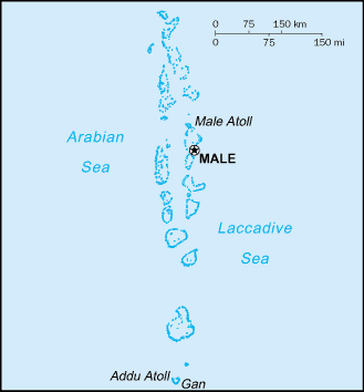
The smallest country in Asia both area and population is the Maldives.Facts about Maldives
| Administrative divisions: | 19 atolls (atholhu , singular and plural) and the capital city*; Alifu , Baa , Dhaalu , Faafu , Gaafu Alifu , Gaafu Dhaalu , Gnaviyani , Haa Alifu , Haa Dhaalu , Kaafu , Laamu , Lhaviyani , Maale* (Male) , Meemu , Noonu , Raa , Seenu , Shaviyani , Thaa , Vaavu |
| Area: | total: 300 sq km land: 300 sq km water: 0 sq km |
| Background: | The Maldives was long a sultanate , first under Dutch and then under British protection. It became a republic in 1968 , three years after independence. President Maumoon Abdul GAYOOM dominated the islands' political scene for 30 years , elected to six successive terms by single-party referendums. Following riots in the capital Male in August 2004 , the president and his government pledged to embark upon democratic reforms including a more representative political system and expanded political freedoms. Progress was sluggish , however , and many promised reforms were slow to be realized. Nonetheless , political parties were legalized in 2005. In June 2008 , a constituent assembly - termed the "Special Majlis" - finalized a new constitution , which was ratified by the president in August. The first-ever presidential elections under a multi-candidate , multi-party system were held in October 2008. GAYOOM was defeated in a runoff poll by Mohamed NASHEED , a political activist who had been jailed several years earlier by the former regime. Challenges facing the new president include strengthening democracy and combating poverty and drug abuse. |
| Flag description: | red with a large green rectangle in the center bearing a vertical white crescent; the closed side of the crescent is on the hoist side of the flag |
| Capital: | name: Male geographic coordinates: 4 10 N , 73 30 E time difference: UTC+5 (10 hours ahead of Washington , DC during Standard Time) |
| Climate: | tropical; hot , humid; dry , northeast monsoon (November to March); rainy , southwest monsoon (June to August) |
| Currency code: | rufiyaa (MVR) |
| Ethnic groups: | South Indians , Sinhalese , Arabs |
| Geographic coordinates: | 3 15 N , 73 00 E |
| Geography note: | 1 ,190 coral islands grouped into 26 atolls (200 inhabited islands , plus 80 islands with tourist resorts); archipelago with strategic location astride and along major sea lanes in Indian Ocean |
| Government type: | republic |
| Imports partners: | Singapore 22.7% , UAE 15.5% , India 11.2% , Malaysia 10.8% , Sri Lanka 5.7% , Thailand 5.3% (2007) |
| Internet country code: | .mv |
| Land boundaries: | 644 km |
| Neighbouring countries: | 0 km |
| Languages: | Maldivian Dhivehi (dialect of Sinhala , script derived from Arabic) , English spoken by most government officials |
| Location: | Southern Asia , group of atolls in the Indian Ocean , south-southwest of India |
| Map references: | Asia |
| National holiday: | Independence Day , 26 July (1965) |
| Nationality: | noun: Maldivian(s) adjective: Maldivian |
| Natural hazards: | low level of islands makes them sensitive to sea level rise |
| Population: | 385 ,925 (July 2008 est.) |
| Religions: | Sunni Muslim |
| Terrain: | flat , with white sandy beaches |
| Unemployment rate: | NEGL% (2003 est.) |
Capital of Republic of Maldives
Maale (click to view Maale map)
Places in Maldives
Browse the most comprehensive and up-to-date online directory of administrative regions and Street Views in Maldives. Our listings are organized alphabetically, starting from level 1 regions and progressing through to level 2 and eventually level 3 regions, ensuring you can easily navigate and find specific areas of interest.
Felidhu Atoll (1 Google Maps locations)
Gnaviyani Atoll city Google Maps
Haddhunmathi Atoll city Google Maps
Kaafu Atoll (1 Google Maps locations)
Kolhumadulhu Atoll (1 Google Maps locations)
Lhaviyani Atoll (1 Google Maps locations)
Mulaku Atoll (2 Google Maps locations)
Northern Huvadhu Atoll (1 Google Maps locations)
Northern Maalhosmadulhu Atoll (1 Google Maps locations)
Northern Nilandhe Atoll (1 Google Maps locations)
Northern Thiladhunmathi Atoll (1 Google Maps locations)
Seenu Atoll (3 Google Maps locations)
Southern Huvadhu Atoll (1 Google Maps locations)
Southern Maalhosmadulhu Atoll (1 Google Maps locations)
Southern Miladhunmadulhu Atoll (1 Google Maps locations)
Southern Nilandhe Atoll (2 Google Maps locations)
Southern Thiladhunmathi Atoll (1 Google Maps locations)
Random cities in Maldives
Maale, the capital city of Maldives.Muli
Funadhoo
Mula
Midu
Magoodhoo
Maale
Nolhivaranfaru
Dhidhdhoo
Veymandoo
Gan
Ugoofaaru
Felidhoo
Eydhafushi
Mahibadhoo
Kulhudhuffushi
Viligili
Hithadhoo
Thinadhoo
Naifaru
Link to Maldives Google Maps page
The map of Maldives has already attracted 9604 views. If you wish to embed our comprehensive Maldives map on your site, we offer an easy solution. This map includes free access to Google Maps, gazetteer search, detailed country and city maps, Street View, and essential facts, all ready to enhance your website. To use it, simply copy and paste the provided HTML code into your webpage's source code. We appreciate every link back to our Maps and Driving Directions. Thank you for your support!
| Text link to: Maldives map and facts page |
This Maldives map is intended solely for informational purposes. No representations or warranties are made concerning its accuracy or reliability. Users assume all risks associated with the use of Google Maps and Google Driving Directions. World Route Planner is not liable for any losses or delays that may occur from using this free Maldives map.