 Hellenic Republic Google Maps and Facts
Welcome to the Google Maps of Greece (GR) and the comprehensive location list for this country. World Route Planner, together with its detailed Greece page, turns Google Maps Sightseeing into a meaningful experience! Our extensive destination gazetteer, coupled with Driving Directions to Greece, allows you to explore Greece through detailed satellite imagery and street views—fast, free, and easier than ever before.
Browse through the list of administrative regions in Greece, navigate through these regions to find a place of interest, and book your hotel with the Best Price Guarantee! Your journey through Greece via Google Satellite Map Sightseeing and Street View starts here.
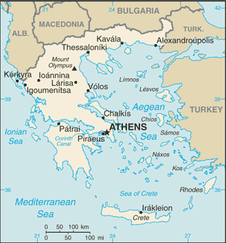
Greece Google Maps
To activate Street View on any city of Greece, drag above the Zoom feature the yellow little man in the map.
Facts about Greece
| Administrative divisions: | 51 prefectures (nomoi , singular - nomos) and 1 autonomous region*; Achaia , Agion Oros* (Mt. Athos) , Aitolia kai Akarnania , Argolis , Arkadia , Arta , Attiki , Chalkidiki , Chanion , Chios , Dodekanisos , Drama , Evros , Evrytania , Evvoia , Florina , Fokidos , Fthiotis , Grevena , Ileia , Imathia , Ioannina , Irakleion , Karditsa , Kastoria , Kavala , Kefallinia , Kerkyra , Kilkis , Korinthia , Kozani , Kyklades , Lakonia , Larisa , Lasithi , Lefkas , Lesvos , Magnisia , Messinia , Pella , Pieria , Preveza , Rethynnis , Rodopi , Samos , Serrai , Thesprotia , Thessaloniki , Trikala , Voiotia , Xanthi , Zakynthos |
| Area: | total: 131 ,940 sq km land: 130 ,800 sq km water: 1 ,140 sq km |
| Background: | Greece achieved independence from the Ottoman Empire in 1829. During the second half of the 19th century and the first half of the 20th century , it gradually added neighboring islands and territories , most with Greek-speaking populations. In World War II , Greece was first invaded by Italy (1940) and subsequently occupied by Germany (1941-44); fighting endured in a protracted civil war between supporters of the king and Communist rebels. Following the latter's defeat in 1949 , Greece joined NATO in 1952. A military dictatorship , which in 1967 suspended many political liberties and forced the king to flee the country , lasted seven years. The 1974 democratic elections and a referendum created a parliamentary republic and abolished the monarchy. In 1981 , Greece joined the EC (now the EU); it became the 12th member of the European Economic and Monetary Union in 2001. |
| Flag description: | nine equal horizontal stripes of blue alternating with white; there is a blue square in the upper hoist-side corner bearing a white cross; the cross symbolizes Greek Orthodoxy , the established religion of the country |
| Capital: | name: Athens geographic coordinates: 37 59 N , 23 44 E time difference: UTC+2 (7 hours ahead of Washington , DC during Standard Time) daylight saving time: +1hr , begins last Sunday in March; ends last Sunday in October |
| Climate: | temperate; mild , wet winters; hot , dry summers |
| Currency code: | euro (EUR) |
| Ethnic groups: | population: Greek 93% , other (foreign citizens) 7% (2001 census) note: percents represent citizenship , since Greece does not collect data on ethnicity |
| Geographic coordinates: | 39 00 N , 22 00 E |
| Geography note: | strategic location dominating the Aegean Sea and southern approach to Turkish Straits; a peninsular country , possessing an archipelago of about 2 ,000 islands |
| Government type: | parliamentary republic |
| Imports partners: | Germany 12.9% , Italy 11.7% , Russia 5.6% , France 5.6% , China 5% , Netherlands 5% (2007) |
| Internet country code: | .gr |
| Land boundaries: | 13 ,676 km |
| Neighbouring countries: | total: 1 ,228 km border countries: Albania 282 km , Bulgaria 494 km , Turkey 206 km , Macedonia 246 km |
| Languages: | Greek 99% (official) , other 1% (includes English and French) |
| Location: | Southern Europe , bordering the Aegean Sea , Ionian Sea , and the Mediterranean Sea , between Albania and Turkey |
| Map references: | Europe |
| National holiday: | Independence Day , 25 March (1821) |
| Nationality: | noun: Greek(s) adjective: Greek |
| Natural hazards: | severe earthquakes |
| Population: | 10 ,722 ,816 (July 2008 est.) |
| Religions: | Greek Orthodox 98% , Muslim 1.3% , other 0.7% |
| Terrain: | mostly mountains with ranges extending into the sea as peninsulas or chains of islands |
| Unemployment rate: | 8.3% (2007 est.) |
Capital of Hellenic Republic
Athínai (click to view Athínai map)
Places in Greece
Browse the most comprehensive and up-to-date online directory of administrative regions and Street Views in Greece. Our listings are organized alphabetically, starting from level 1 regions and progressing through to level 2 and eventually level 3 regions, ensuring you can easily navigate and find specific areas of interest.
Attica Periphery (329 google map locations)
Central Greece Periphery (1069 google map locations)
Central Macedonia Periphery (1011 google map locations)
Crete Periphery (1434 google map locations)
Drama city Google map
East Macedonia and Thrace Periphery (790 google map locations)
Epirus Periphery (1028 google map locations)
Evros city Google map
Florina city Google map
Grevena city Google map
Imathia city Google map
Ionian Islands Periphery (556 google map locations)
Kastoria city Google map
Kastroúngaina city Google map
Kavala city Google map
Kozani city Google map
Mikrokhórion city Google map
North Aegean Periphery (325 google map locations)
Pella city Google map
Peloponnese Periphery (1651 google map locations)
Pétas city Google map
Rhodope city Google map
Serres city Google map
South Aegean Periphery (392 google map locations)
Thessaloniki city Google map
Thessaly Periphery (898 google map locations)
West Greece Periphery (1354 google map locations)
West Macedonia Periphery (510 google map locations)
Xanthi city Google map
Xirokarítaina city Google map
Random cities in Greece
Athínai, the capital city of Greece.Káto Khóra
Tápai
Sinoikismós Káto Loutrakíou
Chrysavgí
Tsepriés
Névra
Kastélli
Dodóni
Távros
Katsimitraíika
Pelekanádha
Dhrími
Gorgogýrion
Mandasiá
Georgítsa
Kastrákion
Palaiomýlia
Mantzouraíïka
Dhímaina
Link to Greece Google Maps page
The map of Greece has already attracted 7427 views. If you wish to embed our comprehensive Greece map on your site, we offer an easy solution. This map includes free access to Google Maps, gazetteer search, detailed country and city maps, Street View, and essential facts, all ready to enhance your website. To use it, simply copy and paste the provided HTML code into your webpage's source code. We appreciate every link back to our Maps and Driving Directions. Thank you for your support!
| Text link to: Greece map and facts page |
This Greece map is intended solely for informational purposes. No representations or warranties are made concerning its accuracy or reliability. Users assume all risks associated with the use of Google Maps and Google Driving Directions. World Route Planner is not liable for any losses or delays that may occur from using this free Greece map.