 Kingdom of Belgium Google Maps and Facts
Welcome to the Google Maps of Belgium (BE) and the comprehensive location list for this country. World Route Planner, together with its detailed Belgium page, turns Google Maps Sightseeing into a meaningful experience! Our extensive destination gazetteer, coupled with Driving Directions to Belgium, allows you to explore Belgium through detailed satellite imagery and street views—fast, free, and easier than ever before.
Browse through the list of administrative regions in Belgium, navigate through these regions to find a place of interest, and book your hotel with the Best Price Guarantee! Your journey through Belgium via Google Satellite Map Sightseeing and Street View starts here.
Belgium Google Maps
To activate Street View on any city of Belgium, drag above the Zoom feature the yellow little man in the map.
Facts about Belgium
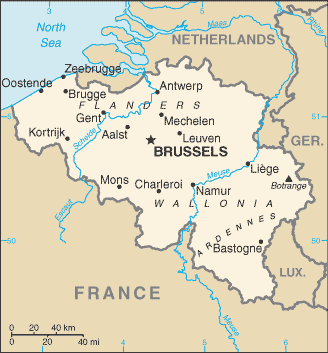
| Administrative divisions: | 10 provinces (French: provinces , singular - province; Dutch: provincies , singular - provincie) and 3 regions* (French: regions; Dutch: gewesten); Brussels* (Bruxelles) capital region; Flanders* region (five provinces): Antwerpen (Antwerp) , Limburg , Oost-Vlaanderen (East Flanders) , Vlaams-Brabant (Flemish Brabant) , West-Vlaanderen (West Flanders); Wallonia* region (five provinces): Brabant Wallon (Walloon Brabant) , Hainaut , Liege , Luxembourg , Namur note: as a result of the 1993 constitutional revision that furthered devolution into a federal state , there are now three levels of government (federal , regional , and linguistic community) with a complex division of responsibilities |
| Area: | total: 30 ,528 sq km land: 30 ,278 sq km water: 250 sq km |
| Background: | Belgium became independent from the Netherlands in 1830; it was occupied by Germany during World Wars I and II. The country prospered in the past half century as a modern , technologically advanced European state and member of NATO and the EU. Tensions between the Dutch-speaking Flemings of the north and the French-speaking Walloons of the south have led in recent years to constitutional amendments granting these regions formal recognition and autonomy. |
| Flag description: | three equal vertical bands of black (hoist side) , yellow , and red note: the design was based on the flag of France |
| Capital: | name: Brussels geographic coordinates: 50 50 N , 4 20 E time difference: UTC+1 (6 hours ahead of Washington , DC during Standard Time) daylight saving time: +1hr , begins last Sunday in March; ends last Sunday in October |
| Climate: | temperate; mild winters , cool summers; rainy , humid , cloudy |
| Currency code: | euro (EUR) |
| Ethnic groups: | Fleming 58% , Walloon 31% , mixed or other 11% |
| Geographic coordinates: | 50 50 N , 4 00 E |
| Geography note: | crossroads of Western Europe; most West European capitals within 1 ,000 km of Brussels , the seat of both the European Union and NATO |
| Government type: | federal parliamentary democracy under a constitutional monarchy |
| Imports partners: | Germany 17.7% , Netherlands 17.6% , France 11.2% , UK 6.2% , US 5.4% , Ireland 4.9% , China 4.1% (2007) |
| Internet country code: | .be |
| Land boundaries: | 66.5 km |
| Neighbouring countries: | total: 1 ,385 km border countries: France 620 km , Germany 167 km , Luxembourg 148 km , Netherlands 450 km |
| Languages: | Dutch (official) 60% , French (official) 40% , German (official) less than 1% , legally bilingual (Dutch and French) |
| Location: | Western Europe , bordering the North Sea , between France and the Netherlands |
| Map references: | Europe |
| National holiday: | 21 July (1831) ascension to the Throne of King LEOPOLD I |
| Nationality: | noun: Belgian(s) adjective: Belgian |
| Natural hazards: | flooding is a threat along rivers and in areas of reclaimed coastal land , protected from the sea by concrete dikes |
| Population: | 10 ,403 ,951 (July 2008 est.) |
| Religions: | Roman Catholic 75% , other (includes Protestant) 25% |
| Terrain: | flat coastal plains in northwest , central rolling hills , rugged mountains of Ardennes Forest in southeast |
| Unemployment rate: | 7.5% (2007 est.) |
Capital of Kingdom of Belgium
Brussel (click to view Brussel map)
Places in Belgium
Browse the most comprehensive and up-to-date online directory of administrative regions and Street Views in Belgium. Our listings are organized alphabetically, starting from level 1 regions and progressing through to level 2 and eventually level 3 regions, ensuring you can easily navigate and find specific areas of interest.
Brussels-Capital Region (84 google map locations)
East Flanders (1751 google map locations)
Flemish Brabant (1014 google map locations)
Hainaut (1608 google map locations)
Liège (1448 google map locations)
Luxembourg (1274 google map locations)
Namur (1034 google map locations)
Walloon Brabant (471 google map locations)
West Flanders (978 google map locations)
Random cities in Belgium
Brussel, the capital city of Belgium.Wijnendale
Le Tombeau
Birven
Haie Curie
Bieheide
Grand Berceau
Autelhaut
Solières
Over de Heibloem
Geenstraat
Alle
Romershoven
Pützhag
Bodange
Bierbeek
Wielsbeke
Weyler
Uitbergen
Rodenboom
Link to Belgium Google Maps page
The map of Belgium has already attracted 8280 views. If you wish to embed our comprehensive Belgium map on your site, we offer an easy solution. This map includes free access to Google Maps, gazetteer search, detailed country and city maps, Street View, and essential facts, all ready to enhance your website. To use it, simply copy and paste the provided HTML code into your webpage's source code. We appreciate every link back to our Maps and Driving Directions. Thank you for your support!
| Text link to: Belgium map and facts page |
This Belgium map is intended solely for informational purposes. No representations or warranties are made concerning its accuracy or reliability. Users assume all risks associated with the use of Google Maps and Google Driving Directions. World Route Planner is not liable for any losses or delays that may occur from using this free Belgium map.