Europe Google Maps
The landscape of global sovereignty has dramatically shifted over the past several decades. From just 82 sovereign states in 1950, the number has surged to almost 200 today. This rise can largely be attributed to the fervent push for national self-determination following eras of colonialism and oppression. As the world map has become increasingly dotted with more borders, international border disputes have simultaneously risen. Often fueled by religious or ethnic motivations, these newfound independences have sometimes led to intense internal conflicts, particularly with minority groups. While many nations have transitioned into independence with relative peace, adopting forms of government ranging from multiparty democracies to more centralized powers, others have experienced tumultuous power struggles, occasionally resulting in military dictatorships or individual despots. These early stages of nationhood are critical in shaping the future of emerging states.
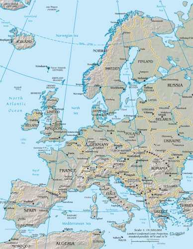
World Route Planner offers an extensive Europe gazetteer, powered by Google Maps, providing detailed Driving Directions and Google Street View across the cities of Europe. Our collaboration with Google Maps delivers the most comprehensive online satellite imagery available, enhancing your exploration of Europe. Our database covers thousands of locations in Europe, categorized by countries, counties, administrative regions, and cities. Additionally, World Route Planner provides precise Time Zones and Daylight maps for Europe. Take advantage of this wealth of information and start exploring Europe with Google Maps today!
Google Maps of Europe
To access Google Street View for any city in Europe, simply drag the yellow pegman icon located above the zoom controls directly onto the map. This will activate the Street View feature, allowing you to explore the streets and landmarks of Europe up close.
Facts of Europe
Europe is the world’s second smallest continent, covering 4,053,309 sq miles (10,498,000 sq km). It comprises 46 separate countries, including Turkey and the Russian Federation, although the greater parts of these nations lie in Asia.- Greatest extent, North-South: 2700 miles / 4300 km
- Greatest extent, East-West: 3500 miles / 5600 km
- Most northerly point: Ostrov Rudol’fa, Russian Federation 81° 47’ N
- Most southerly point: Gávdos, Greece 34° 51’ N
- Most westerly point: Bjargtangar, Iceland 24° 33’ W
- Most easterly point: Mys Flissingskiy, Novaya Zemlya, Russian Federation 69° 03’ E
- Highest recorded temperature: Seville, Spain 122°F (50°C)
- Lowest recorded temperature: Ust ‘Shchugor, Russian Federation -67°F (-55°C)
- Largest lake: Lake Ladoga, Russian Federation, 7100 sq miles (18,390 sq km)
- Highest point: El’brus, Russian Federation 18,510 ft (5642 m)
- Lowest point: Caspian Depression, Russian Federation -92 ft (-28 m) below sea level
Physical Europe
The physical diversity of Europe belies its relatively small size. Mountains enclose the northwest and south. The older, rounded Atlantic Highlands of Scandinavia and the British Isles lie to the north, and the younger, rugged peaks of the Alpine Uplands to the south. In between lies the North European Plain, stretching 2485 miles (4000 km) from The Fens in England to the Ural Mountains in Russia. South of the plain lies a series of gently folded sedimentary rocks separated by ancient plateaus known as massifs.Climate
Europe experiences few extremes in either rainfall or temperature, except in the far north and south. Along the west coast, the warm currents of the North Atlantic Drift moderate temperatures. Although east-west air movement is relatively unimpeded by relief, the Alpine Uplands halt the progress of north-south air masses, protecting most of the Mediterranean from cold, north winds.Shaping the continent
Successive Ice Ages have left many relict landforms across Europe. Present glaciers continue to carve peaks and valleys in the northern Atlantic Highlands and Alpine Uplands. Tectonic activity, both past and present, has shaped southern Europe and Iceland. Active volcanoes and earthquakes still occur in Italy and Greece. Europe’s extensive coastline, particularly in the northwest, is constantly modified by wave action and fluvial deposits.Political Europe
The political boundaries of Europe have changed many times, especially during the 20th century in the aftermath of two world wars, the breakup of the empires of Austria - Hungary, Nazi Germany, and, toward the end of the century, the collapse of communism in Eastern Europe. Yugoslavia's fragmentation has again altered Europe's political map, highlighting a trend toward nationalism and devolution. In contrast, economic federalism is growing. In 1958, the formation of the European Economic Community (now the European Union or EU) started a move toward economic and political union and increased internal migration.Population
Europe is a densely populated, urbanized continent; in Belgium, over 90% of people live in urban areas. The highest population densities are found in an area stretching east from southern Britain and northern France into Germany. The northern fringes are only sparsely populated.Languages
There are three main European language groups: Germanic languages predominate in central and northern Europe; Romance languages in western and Mediterranean Europe and Romania; and Slavic languages are spoken in eastern Europe and the Russian Federation. Isolated pockets of local languages, such as Basque and Gaelic, persist and frequently provide a focus for national identity.Transportation
Despite its fragmented geography and many natural frontiers, European communications are well-developed. Extensive highway links allow rapid road transportation. High-speed rail connections like France’s TGV (Train à Grande Vitesse) and the Channel Tunnel have improved rail travel. However, outdated communication infrastructures in parts of Eastern Europe and insufficient transportation links across the Alps remain weak parts of the network.European resources
Europe’s large tracts of fertile, accessible land, combined with its generally temperate climate, have allowed more land to be used for agricultural purposes than in any other continent. Extensive coal and iron ore deposits created steel and manufacturing industries during the 19th and 20th centuries. Today, although natural resources have been widely exploited, and heavy industry is of declining importance, the growth of hi-tech and service industries has enabled Europe to maintain its wealth.Industry
Europe’s wealth was generated by the rise of industry and colonial exploitation during the 19th century. The mining of abundant natural resources made Europe the industrial center of the world. Adaptation has been essential in the changing world economy, and a move to service-based industries has been widespread except in Eastern Europe, where heavy industry still dominates.Standard of living
Living standards in Western Europe are among the highest in the world, although there is a growing sector of homeless, jobless people. Eastern Europeans have lower overall standards of living – a legacy of stagnated economies.Mineral resources
Fossil fuels are Europe’s main mineral resource, although fuel demand far outstrips production. Sizeable coal reserves remain in the Donbas in Ukraine, Germany’s Ruhr Valley, and Poland. Oil and gas reserves are found mainly in the North Sea, the Volga Basin, and the Caucasus.Environmental issues
The partially enclosed waters of the Baltic and Mediterranean seas have become heavily polluted, while the Barents Sea is contaminated with spent nuclear fuel from Russia’s navy. During the later stages of the 20th Century, acid rain caused by unchecked emissions from factories and power stations was actively destroying northern forests. However, international efforts to reduce pollution have significantly improved in many areas since then.Using the land and sea
Europe’s swelling urban population and the outward expansion of many cities have created acute competition for land. Despite this, European resourcefulness has maximized land potential, and over half of Europe’s land is still used for various agricultural purposes. Land in northern Europe is used for cattle-rearing, pasture, and arable crops. Toward the Mediterranean, the mild climate allows the growing of grapes for wine, olives, sunflowers, tobacco, and citrus fruits. EU subsidies, however, have resulted in massive overproduction, and a land “set-aside” policy has been introduced.Countries in Europe with Google Maps and Gazetteers
Browse the most comprehensive and up-to-date online directory of countries and administrative regions in Europe. Our listings are sorted alphabetically from level 1 to level 2 and up to level 3 regions, ensuring you can easily find specific locations. Integrated with Google Maps and Driving Directions, we provide all the necessary tools to explore Europe. Don't wait—start exploring the unique regions and beautiful countries of Europe today.
The Nature of Politics
Democracy encompasses a wide spectrum of governance practices. In its most robust form, it involves multiparty elections and fair representation. However, in some contexts, such as in Singapore, what is termed democracy can closely resemble single-party rule, where alternative political competition is limited. Conversely, in despotic regimes, power is consolidated in the hands of a single authority, often ruling through personal decree rather than through democratic processes. In such systems, institutions like the parliament and the military typically function as extensions of the dictator's will, rather than as independent entities serving the public.
The Changing World Map
As of 1950, extensive regions globally remained under the dominion of a few European countries. The decolonization process began in Asia post-World War II, where countries in southern and southeastern Asia pursued and achieved self-determination. By the 1960s, numerous African states had gained independence, significantly reducing the scope of European overseas empires by 1965. The final major phase of decolonization occurred with the dissolution of the Soviet Union and the Eastern bloc after 1990. Today, the decolonization process persists as the remaining vestiges of European colonialism, often small island nations, increasingly advocate for independence.
International boundary determinations can be based on various criteria. Borders of older states often follow natural features; others reflect religious and ethnic divides; some are remnants of complicated histories of conflict and colonialism, while others result from international agreements or arbitration.
Post-colonial borders
As European colonial empires in Africa were dismantled in the latter half of the 20th century, the resulting African state borders often replicated the colonial lines. These were drawn by colonial administrators who frequently lacked adequate geographical knowledge, leading to arbitrary divisions among people of different languages, races, religions, and customs. This confused legacy has often resulted in civil and international conflicts.
Physical borders
Many of the world's countries are delineated by physical borders such as lakes, rivers, and mountains. However, demarcating these boundaries can lead to disputes over the control of waterways, water resources, and fisheries, which are common causes of international contention.
International disputes
Today, there are over 60 disputed borders or territories globally. While many of these disputes may be resolved through peaceful negotiations, certain areas have become focal points for international conflicts. Ethnic tensions and the quest for valuable natural resources have historically been significant sources of territorial disputes. The turmoil experienced in parts of Africa during the postcolonial era is partly due to the 19th-century division of the continent, which sowed seeds of conflict by imposing often arbitrary boundaries across linguistic and cultural zones.
Link to Europe Google Maps Page:
Explore our comprehensive map of Europe, which has been viewed 131836 times to date. If you're interested in integrating our Europe map into your website, we offer a seamless method for doing so. Our map includes valuable features such as free Google Maps access, Gazetteer Search, detailed maps of countries and cities, Street View, Driving Directions, and key facts about Europe. Simply copy and paste the HTML code provided below into your website to enhance it with our detailed mapping tools. We appreciate your support and links to World Route Planner!
| Text link to: Europe map and facts page |
This Europe map is provided for informational purposes only. No guarantees are made regarding its accuracy or completeness. Users assume all risks associated with the use of Google Maps and Google Driving Directions. World Route Planner is not responsible for any loss or delays that may occur as a result of using this free Europe map.