 Kingdom of Spain Google Maps and Facts
Welcome to the Google Maps of Spain (ES) and the comprehensive location list for this country. World Route Planner, together with its detailed Spain page, turns Google Maps Sightseeing into a meaningful experience! Our extensive destination gazetteer, coupled with Driving Directions to Spain, allows you to explore Spain through detailed satellite imagery and street views—fast, free, and easier than ever before.
Browse through the list of administrative regions in Spain, navigate through these regions to find a place of interest, and book your hotel with the Best Price Guarantee! Your journey through Spain via Google Satellite Map Sightseeing and Street View starts here.
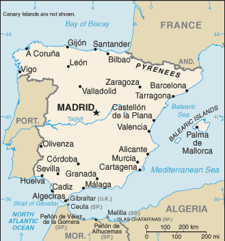
Spain Google Maps
To activate Street View on any city of Spain, drag above the Zoom feature the yellow little man in the map.
Facts about Spain
| Administrative divisions: | 17 autonomous communities (comunidades autonomas , singular - comunidad autonoma) and 2 autonomous cities* (ciudades autonomas , singular - ciudad autonoma); Andalucia , Aragon , Asturias , Baleares (Balearic Islands) , Ceuta* , Canarias (Canary Islands) , Cantabria , Castilla-La Mancha , Castilla y Leon , Cataluna (Catalonia) , Comunidad Valenciana (Valencian Community) , Extremadura , Galicia , La Rioja , Madrid , Melilla* , Murcia , Navarra , Pais Vasco (Basque Country) note: the autonomous cities of Ceuta and Melilla plus three small islands of Islas Chafarinas , Penon de Alhucemas , and Penon de Velez de la Gomera , administered directly by the Spanish central government , are all along the coast of Morocco and are collectively referred to as Places of Sovereignty (Plazas de Soberania) |
| Area: | total: 504 ,782 sq km land: 499 ,542 sq km water: 5 ,240 sq km note: there are two autonomous cities - Ceuta and Melilla - and 17 autonomous communities including Balearic Islands and Canary Islands , and three small Spanish possessions off the coast of Morocco - Islas Chafarinas , Penon de Alhucemas , and Penon de Velez de la Gomera Spratly Islands |
| Background: | Spain's powerful world empire of the 16th and 17th centuries ultimately yielded command of the seas to England. Subsequent failure to embrace the mercantile and industrial revolutions caused the country to fall behind Britain , France , and Germany in economic and political power. Spain remained neutral in World Wars I and II but suffered through a devastating civil war (1936-39). A peaceful transition to democracy following the death of dictator Francisco FRANCO in 1975 , and rapid economic modernization (Spain joined the EU in 1986) have given Spain one of the most dynamic economies in Europe and made it a global champion of freedom. Continuing challenges include Basque Fatherland and Liberty (ETA) terrorism , illegal immigration , and slowing economic growth. Spratly Islands |
| Flag description: | three horizontal bands of red (top) , yellow (double width) , and red with the national coat of arms on the hoist side of the yellow band; the coat of arms is quartered to display the emblems of the traditional kingdoms of Spain (clockwise from upper left , Castile , Leon , Navarre , and Aragon) while Granada is represented by the stylized pomegranate at the bottom of the shield; the arms are framed by two columns representing the Pillars of Hercules , which are the two promontories (Gibraltar and Ceuta) on either side of the eastern end of the Strait of Gibraltar; the red scroll across the two columns bears the imperial motto of "Plus Ultra" (further beyond) referring to Spanish lands beyond Europe |
| Capital: | name: Madrid geographic coordinates: 40 24 N , 3 41 W time difference: UTC+1 (6 hours ahead of Washington , DC during Standard Time) daylight saving time: +1hr , begins last Sunday in March; ends last Sunday in October note: Spain is divided into two time zones including the Canary Islands |
| Climate: | temperate; clear , hot summers in interior , more moderate and cloudy along coast; cloudy , cold winters in interior , partly cloudy and cool along coast Spratly Islands |
| Currency code: | |
| Ethnic groups: | composite of Mediterranean and Nordic types |
| Geographic coordinates: | 40 00 N , 4 00 W Spratly Islands |
| Geography note: | strategic location along approaches to Strait of Gibraltar Spratly Islands |
| Government type: | parliamentary monarchy |
| Imports partners: | Germany 15.7% , France 12.7% , Italy 8.4% , China 5.8% , UK 4.8% , Netherlands 4.6% (2007) |
| Internet country code: | .es |
| Land boundaries: | 4 ,964 km Spratly Islands |
| Neighbouring countries: | total: 1 ,917.8 km border countries: Andorra 63.7 km , France 623 km , Gibraltar 1.2 km , Portugal 1 ,214 km , Morocco (Ceuta) 6.3 km , Morocco (Melilla) 9.6 km Spratly Islands |
| Languages: | Castilian Spanish (official) 74% , Catalan 17% , Galician 7% , Basque 2% , are official regionally |
| Location: | Southwestern Europe , bordering the Bay of Biscay , Mediterranean Sea , North Atlantic Ocean , and Pyrenees Mountains , southwest of France Spratly Islands |
| Map references: | Europe Spratly Islands |
| National holiday: | National Day , 12 October (1492); year when Columbus first set foot in the Americas |
| Nationality: | noun: Spaniard(s) adjective: Spanish |
| Natural hazards: | periodic droughts Spratly Islands |
| Population: | 40 ,491 ,052 (July 2008 est.) Spratly Islands |
| Religions: | Roman Catholic 94% , other 6% |
| Terrain: | large , flat to dissected plateau surrounded by rugged hills; Pyrenees in north Spratly Islands |
| Unemployment rate: | 8.3% (2007 est.) |
Capital of Kingdom of Spain
Madrid (click to view Madrid map)
Places in Spain
Browse the most comprehensive and up-to-date online directory of administrative regions and Street Views in Spain. Our listings are organized alphabetically, starting from level 1 regions and progressing through to level 2 and eventually level 3 regions, ensuring you can easily navigate and find specific areas of interest.
Aragon (1406 Google Maps locations)
Asturias Province (2378 Google Maps locations)
Balearic Islands Province (142 Google Maps locations)
Basque Country (1114 Google Maps locations)
Canary Islands (639 Google Maps locations)
Cantabria (836 Google Maps locations)
Castile and León (5712 Google Maps locations)
Castile-La Mancha (1681 Google Maps locations)
Catalonia (1544 Google Maps locations)
Extremadura (630 Google Maps locations)
Galicia (4242 Google Maps locations)
La Rioja (263 Google Maps locations)
Madrid Province (274 Google Maps locations)
Melilla (1 Google Maps locations)
Murcia Province (589 Google Maps locations)
Navarre Province (624 Google Maps locations)
Valencian Community (1170 Google Maps locations)
Random cities in Spain
Madrid, the capital city of Spain.Farga de Moles
Villaescusa de Roa
Ríomalo de Abajo
Artieta
El Puerto
Abeo
Grijalba
Urdiáin
Monte Fresno
Huerces
Villanueva de la Tercia
San Martín del Obispo
La Cañada
Llamas de Laciana
Sierra de Yeguas
La Cruz
Zorita de la Frontera
Los Espejos de la Reina
Gegunde
Link to Spain Google Maps page
The map of Spain has already attracted 19050 views. If you wish to embed our comprehensive Spain map on your site, we offer an easy solution. This map includes free access to Google Maps, gazetteer search, detailed country and city maps, Street View, and essential facts, all ready to enhance your website. To use it, simply copy and paste the provided HTML code into your webpage's source code. We appreciate every link back to our Maps and Driving Directions. Thank you for your support!
| Text link to: Spain map and facts page |
This Spain map is intended solely for informational purposes. No representations or warranties are made concerning its accuracy or reliability. Users assume all risks associated with the use of Google Maps and Google Driving Directions. World Route Planner is not liable for any losses or delays that may occur from using this free Spain map.