 Republic of Equatorial Guinea Google Maps and Facts
Welcome to the Google Maps of Equatorial Guinea (GQ) and the comprehensive location list for this country. World Route Planner, together with its detailed Equatorial Guinea page, turns Google Maps Sightseeing into a meaningful experience! Our extensive destination gazetteer, coupled with Driving Directions to Equatorial Guinea, allows you to explore Equatorial Guinea through detailed satellite imagery and street views—fast, free, and easier than ever before.
Browse through the list of administrative regions in Equatorial Guinea, navigate through these regions to find a place of interest, and book your hotel with the Best Price Guarantee! Your journey through Equatorial Guinea via Google Satellite Map Sightseeing and Street View starts here.
Equatorial Guinea Google Maps
To activate Street View on any city of Equatorial Guinea, drag above the Zoom feature the yellow little man in the map.
Facts about Equatorial Guinea
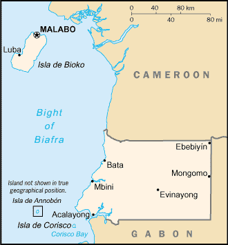
| Administrative divisions: | 7 provinces (provincias , singular - provincia); Annobon , Bioko Norte , Bioko Sur , Centro Sur , Kie-Ntem , Litoral , Wele-Nzas |
| Area: | total: 28 ,051 sq km land: 28 ,051 sq km water: 0 sq km |
| Background: | Equatorial Guinea gained independence in 1968 after 190 years of Spanish rule. This tiny country , composed of a mainland portion plus five inhabited islands , is one of the smallest on the African continent. President Teodoro OBIANG NGUEMA MBASOGO has ruled the country since 1979 when he seized power in a coup. Although nominally a constitutional democracy since 1991 , the 1996 and 2002 presidential elections - as well as the 1999 and 2004 legislative elections - were widely seen as flawed. The president exerts almost total control over the political system and has discouraged political opposition. Equatorial Guinea has experienced rapid economic growth due to the discovery of large offshore oil reserves , and in the last decade has become Sub-Saharan Africa's third largest oil exporter. Despite the country's economic windfall from oil production resulting in a massive increase in government revenue in recent years , there have been few improvements in the population's living standards. |
| Flag description: | three equal horizontal bands of green (top) , white , and red with a blue isosceles triangle based on the hoist side and the coat of arms centered in the white band; the coat of arms has six yellow six-pointed stars (representing the mainland and five offshore islands) above a gray shield bearing a silk-cotton tree and below which is a scroll with the motto UNIDAD , PAZ , JUSTICIA (Unity , Peace , Justice) |
| Capital: | name: Malabo geographic coordinates: 3 45 N , 8 47 E time difference: UTC+1 (6 hours ahead of Washington , DC during Standard Time) |
| Climate: | tropical; always hot , humid |
| Currency code: | Communaute Financiere Africaine franc (XAF); note - responsible authority is the Bank of the Central African States |
| Ethnic groups: | Fang 85.7% , Bubi 6.5% , Mdowe 3.6% , Annobon 1.6% , Bujeba 1.1% , other 1.4% (1994 census) |
| Geographic coordinates: | 2 00 N , 10 00 E |
| Geography note: | insular and continental regions widely separated |
| Government type: | republic |
| Imports partners: | US 18.2% , Spain 12.7% , Cote d'Ivoire 11% , France 8.9% , South Korea 8.5% , China 7.1% , Italy 6.1% , UK 6% (2007) |
| Internet country code: | .gq |
| Land boundaries: | 296 km |
| Neighbouring countries: | total: 539 km border countries: Cameroon 189 km , Gabon 350 km |
| Languages: | Spanish 67.6% (official) , other 32.4% (includes French (official) , Fang , Bubi) (1994 census) |
| Location: | Western Africa , bordering the Bight of Biafra , between Cameroon and Gabon |
| Map references: | Africa |
| National holiday: | Independence Day , 12 October (1968) |
| Nationality: | noun: Equatorial Guinean(s) or Equatoguinean(s) adjective: Equatorial Guinean or Equatoguinean |
| Natural hazards: | violent windstorms , flash floods |
| Population: | 616 ,459 (July 2008 est.) |
| Religions: | nominally Christian and predominantly Roman Catholic , pagan practices |
| Terrain: | coastal plains rise to interior hills; islands are volcanic |
| Unemployment rate: | 30% (1998 est.) |
Capital of Republic of Equatorial Guinea
Malabo (click to view Malabo map)
Places in Equatorial Guinea
Browse the most comprehensive and up-to-date online directory of administrative regions and Street Views in Equatorial Guinea. Our listings are organized alphabetically, starting from level 1 regions and progressing through to level 2 and eventually level 3 regions, ensuring you can easily navigate and find specific areas of interest.
Bioko Norte Region (21 google map locations)
Bioko Sur Region (36 google map locations)
Centro Sur Region (412 google map locations)
Litoral Region (555 google map locations)
Wele-Nzas Region (314 google map locations)
Random cities in Equatorial Guinea
Malabo, the capital city of Equatorial Guinea.Mecac
Mvang
Nsomo
Foo
Ononobere
Macoc
Ncolamvan
Bocoricho Ombori
Ebongle
Ndyong
Nsamatá
Ncoasas
Etong
Mveng
Santa Cruz
Luba
Eves
Belombo
Eboga
Link to Equatorial Guinea Google Maps page
The map of Equatorial Guinea has already attracted 3352 views. If you wish to embed our comprehensive Equatorial Guinea map on your site, we offer an easy solution. This map includes free access to Google Maps, gazetteer search, detailed country and city maps, Street View, and essential facts, all ready to enhance your website. To use it, simply copy and paste the provided HTML code into your webpage's source code. We appreciate every link back to our Maps and Driving Directions. Thank you for your support!
| Text link to: Equatorial Guinea map and facts page |
This Equatorial Guinea map is intended solely for informational purposes. No representations or warranties are made concerning its accuracy or reliability. Users assume all risks associated with the use of Google Maps and Google Driving Directions. World Route Planner is not liable for any losses or delays that may occur from using this free Equatorial Guinea map.