 Federal Republic of Nigeria Google Maps and Facts
Welcome to the Google Maps of Nigeria (NG) and the comprehensive location list for this country. World Route Planner, together with its detailed Nigeria page, turns Google Maps Sightseeing into a meaningful experience! Our extensive destination gazetteer, coupled with Driving Directions to Nigeria, allows you to explore Nigeria through detailed satellite imagery and street views—fast, free, and easier than ever before.
Browse through the list of administrative regions in Nigeria, navigate through these regions to find a place of interest, and book your hotel with the Best Price Guarantee! Your journey through Nigeria via Google Satellite Map Sightseeing and Street View starts here.
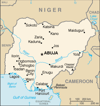
Nigeria Google Maps
To activate Street View on any city of Nigeria, drag above the Zoom feature the yellow little man in the map.
Facts about Nigeria
| Administrative divisions: | 36 states and 1 territory*; Abia , Adamawa , Akwa Ibom , Anambra , Bauchi , Bayelsa , Benue , Borno , Cross River , Delta , Ebonyi , Edo , Ekiti , Enugu , Federal Capital Territory* , Gombe , Imo , Jigawa , Kaduna , Kano , Katsina , Kebbi , Kogi , Kwara , Lagos , Nassarawa , Niger , Ogun , Ondo , Osun , Oyo , Plateau , Rivers , Sokoto , Taraba , Yobe , Zamfara |
| Area: | total: 923 ,768 sq km land: 910 ,768 sq km water: 13 ,000 sq km |
| Background: | British influence and control over what would become Nigeria grew through the 19th century. A series of constitutions after World War II granted Nigeria greater autonomy; independence came in 1960. Following nearly 16 years of military rule , a new constitution was adopted in 1999 , and a peaceful transition to civilian government was completed. The government continues to face the daunting task of reforming a petroleum-based economy , whose revenues have been squandered through corruption and mismanagement , and institutionalizing democracy. In addition , Nigeria continues to experience longstanding ethnic and religious tensions. Although both the 2003 and 2007 presidential elections were marred by significant irregularities and violence , Nigeria is currently experiencing its longest period of civilian rule since independence. The general elections of April 2007 marked the first civilian-to-civilian transfer of power in the country's history. |
| Flag description: | three equal vertical bands of green (hoist side) , white , and green |
| Capital: | name: Abuja geographic coordinates: 9 12 N , 7 11 E time difference: UTC+1 (6 hours ahead of Washington , DC during Standard Time) |
| Climate: | varies; equatorial in south , tropical in center , arid in north |
| Currency code: | naira (NGN) |
| Ethnic groups: | Nigeria , Africa's most populous country , is composed of more than 250 ethnic groups; the following are the most populous and politically influential: Hausa and Fulani 29% , Yoruba 21% , Igbo (Ibo) 18% , Ijaw 10% , Kanuri 4% , Ibibio 3.5% , Tiv 2.5% |
| Geographic coordinates: | 10 00 N , 8 00 E |
| Geography note: | the Niger enters the country in the northwest and flows southward through tropical rain forests and swamps to its delta in the Gulf of Guinea |
| Government type: | federal republic |
| Imports partners: | China 11% , Netherlands 8.1% , US 8% , UK 5.8% , Brazil 5.1% , France 4.4% , Germany 4.3% (2007) |
| Internet country code: | .ng |
| Land boundaries: | 853 km |
| Neighbouring countries: | total: 4 ,047 km border countries: Benin 773 km , Cameroon 1 ,690 km , Chad 87 km , Niger 1 ,497 km |
| Languages: | English (official) , Hausa , Yoruba , Igbo (Ibo) , Fulani |
| Location: | Western Africa , bordering the Gulf of Guinea , between Benin and Cameroon |
| Map references: | Africa |
| National holiday: | Independence Day (National Day) , 1 October (1960) |
| Nationality: | noun: Nigerian(s) adjective: Nigerian |
| Natural hazards: | periodic droughts; flooding |
| Population: | 146 ,255 ,312 note: estimates for this country explicitly take into account the effects of excess mortality due to AIDS; this can result in lower life expectancy , higher infant mortality , higher death rates , lower population growth rates , and changes in the distribution of population by age and sex than would otherwise be expected (July 2008 est.) |
| Religions: | Muslim 50% , Christian 40% , indigenous beliefs 10% |
| Terrain: | southern lowlands merge into central hills and plateaus; mountains in southeast , plains in north |
| Unemployment rate: | 4.9% (2007 est.) |
Capital of Federal Republic of Nigeria
Abuja (click to view Abuja map)
Places in Nigeria
Browse the most comprehensive and up-to-date online directory of administrative regions and Street Views in Nigeria. Our listings are organized alphabetically, starting from level 1 regions and progressing through to level 2 and eventually level 3 regions, ensuring you can easily navigate and find specific areas of interest.
Abuja Federal Capital Territory (239 google map locations)
Adamawa State (1972 google map locations)
Akwa Ibom State (692 google map locations)
Anambra State (144 google map locations)
Bauchi State (1304 google map locations)
Bayelsa State (1 google map locations)
Benue State (2182 google map locations)
Borno State (1641 google map locations)
Cross River State (679 google map locations)
Delta State (611 google map locations)
Ebonyi State (1 google map locations)
Edo State (679 google map locations)
Ekiti State (1 google map locations)
Enugu State (497 google map locations)
Gombe State (17 google map locations)
Imo State (261 google map locations)
Jigawa State (657 google map locations)
Kaduna State (1197 google map locations)
Katsina State (616 google map locations)
Kebbi State (1128 google map locations)
Kogi State (526 google map locations)
Kwara State (773 google map locations)
Lagos State (417 google map locations)
Nassarawa State (127 google map locations)
Niger State (1532 google map locations)
Ogun State (1324 google map locations)
Ondo State (400 google map locations)
Osun State (625 google map locations)
Oyo State (2199 google map locations)
Plateau State (1006 google map locations)
Rivers State (929 google map locations)
Sokoto State (1393 google map locations)
Taraba State (1420 google map locations)
Yobe State (721 google map locations)
Zamfara State (58 google map locations)
Random cities in Nigeria
Abuja, the capital city of Nigeria.Olayiki
Tunga Jipere
Kaanen
Tungan Chafa
Jakpa
Gusun
Lopere
Mabiro
Eruna Eru
Lushe
Wauro Jabbe
Kori
Majara
Gidan Maigemi
Baban Dada
Karauchi
Ozanisi
Kurbau
Urhuokhokhor
Link to Nigeria Google Maps page
The map of Nigeria has already attracted 12739 views. If you wish to embed our comprehensive Nigeria map on your site, we offer an easy solution. This map includes free access to Google Maps, gazetteer search, detailed country and city maps, Street View, and essential facts, all ready to enhance your website. To use it, simply copy and paste the provided HTML code into your webpage's source code. We appreciate every link back to our Maps and Driving Directions. Thank you for your support!
| Text link to: Nigeria map and facts page |
This Nigeria map is intended solely for informational purposes. No representations or warranties are made concerning its accuracy or reliability. Users assume all risks associated with the use of Google Maps and Google Driving Directions. World Route Planner is not liable for any losses or delays that may occur from using this free Nigeria map.