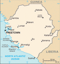
 Republic of Sierra Leone Google Maps and Facts
Welcome to the Google Maps of Sierra Leone (SL) and the comprehensive location list for this country. World Route Planner, together with its detailed Sierra Leone page, turns Google Maps Sightseeing into a meaningful experience! Our extensive destination gazetteer, coupled with Driving Directions to Sierra Leone, allows you to explore Sierra Leone through detailed satellite imagery and street views—fast, free, and easier than ever before.
Browse through the list of administrative regions in Sierra Leone, navigate through these regions to find a place of interest, and book your hotel with the Best Price Guarantee! Your journey through Sierra Leone via Google Satellite Map Sightseeing and Street View starts here.
Sierra Leone Google Maps
To activate Street View on any city of Sierra Leone, drag above the Zoom feature the yellow little man in the map.
Facts about Sierra Leone
| Administrative divisions: | 3 provinces and 1 area*; Eastern , Northern , Southern , Western* |
| Area: | total: 71 ,740 sq km land: 71 ,620 sq km water: 120 sq km |
| Background: | Democracy is slowly being reestablished after the civil war from 1991 to 2002 that resulted in tens of thousands of deaths and the displacement of more than 2 million people (about one-third of the population). The military , which took over full responsibility for security following the departure of UN peacekeepers at the end of 2005 , is increasingly developing as a guarantor of the country's stability. The armed forces remained on the sideline during the 2007 presidential election , but still look to the UN Integrated Office in Sierra Leone (UNIOSIL) - a civilian UN mission - to support efforts to consolidate peace. The new government's priorities include furthering development , creating jobs , and stamping out endemic corruption. |
| Flag description: | three equal horizontal bands of light green (top) , white , and light blue |
| Capital: | name: Freetown geographic coordinates: 8 30 N , 13 15 W time difference: UTC 0 (5 hours ahead of Washington , DC during Standard Time) |
| Climate: | tropical; hot , humid; summer rainy season (May to December); winter dry season (December to April) |
| Currency code: | |
| Ethnic groups: | 20 African ethnic groups 90% (Temne 30% , Mende 30% , other 30%) , Creole (Krio) 10% (descendants of freed Jamaican slaves who were settled in the Freetown area in the late-18th century) , refugees from Liberia's recent civil war , small numbers of Europeans , Lebanese , Pakistanis , and Indians |
| Geographic coordinates: | 8 30 N , 11 30 W |
| Geography note: | rainfall along the coast can reach 495 cm (195 inches) a year , making it one of the wettest places along coastal , western Africa |
| Government type: | constitutional democracy |
| Imports partners: | Cote d'Ivoire 9.5% , China 9.5% , US 9% , Brazil 7% , UK 5.8% , Netherlands 4.8% , India 4.4% (2007) |
| Internet country code: | .sl |
| Land boundaries: | 402 km |
| Neighbouring countries: | total: 958 km border countries: Guinea 652 km , Liberia 306 km |
| Languages: | English (official , regular use limited to literate minority) , Mende (principal vernacular in the south) , Temne (principal vernacular in the north) , Krio (English-based Creole , spoken by the descendants of freed Jamaican slaves who were settled in the Freetown area , a lingua franca and a first language for 10% of the population but understood by 95%) |
| Location: | Western Africa , bordering the North Atlantic Ocean , between Guinea and Liberia |
| Map references: | Africa |
| National holiday: | Independence Day , 27 April (1961) |
| Nationality: | noun: Sierra Leonean(s) adjective: Sierra Leonean |
| Natural hazards: | dry , sand-laden harmattan winds blow from the Sahara (December to February); sandstorms , dust storms |
| Population: | 6 ,294 ,774 (July 2008 est.) |
| Religions: | Muslim 60% , Christian 10% , indigenous beliefs 30% |
| Terrain: | coastal belt of mangrove swamps , wooded hill country , upland plateau , mountains in east |
| Unemployment rate: | NA% |
Capital of Republic of Sierra Leone
Freetown (click to view Freetown map)
Places in Sierra Leone
Browse the most comprehensive and up-to-date online directory of administrative regions and Street Views in Sierra Leone. Our listings are organized alphabetically, starting from level 1 regions and progressing through to level 2 and eventually level 3 regions, ensuring you can easily navigate and find specific areas of interest.
Random cities in Sierra Leone
Freetown, the capital city of Sierra Leone.Bandko
Gbasiakonke
Kurako
Shengeputu
Gbangbaia
Makeku
Ma-mange
Bumbe
Diyange
Matoi
Magbengbe
Kumandu
Mawdia
Satamodia
Kabonka
Jahandama
Konakri
Gangama
Konta
Link to Sierra Leone Google Maps page
The map of Sierra Leone has already attracted 3458 views. If you wish to embed our comprehensive Sierra Leone map on your site, we offer an easy solution. This map includes free access to Google Maps, gazetteer search, detailed country and city maps, Street View, and essential facts, all ready to enhance your website. To use it, simply copy and paste the provided HTML code into your webpage's source code. We appreciate every link back to our Maps and Driving Directions. Thank you for your support!
| Text link to: Sierra Leone map and facts page |
This Sierra Leone map is intended solely for informational purposes. No representations or warranties are made concerning its accuracy or reliability. Users assume all risks associated with the use of Google Maps and Google Driving Directions. World Route Planner is not liable for any losses or delays that may occur from using this free Sierra Leone map.
