 United Republic of Tanzania Google Maps and Facts
Welcome to the Google Maps of Tanzania (TZ) and the comprehensive location list for this country. World Route Planner, together with its detailed Tanzania page, turns Google Maps Sightseeing into a meaningful experience! Our extensive destination gazetteer, coupled with Driving Directions to Tanzania, allows you to explore Tanzania through detailed satellite imagery and street views—fast, free, and easier than ever before.
Browse through the list of administrative regions in Tanzania, navigate through these regions to find a place of interest, and book your hotel with the Best Price Guarantee! Your journey through Tanzania via Google Satellite Map Sightseeing and Street View starts here.
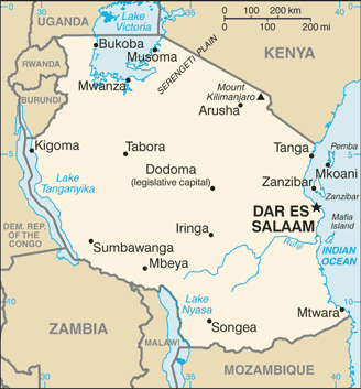
Tanzania Google Maps
To activate Street View on any city of Tanzania, drag above the Zoom feature the yellow little man in the map.
Facts about Tanzania
| Administrative divisions: | 26 regions; Arusha , Dar es Salaam , Dodoma , Iringa , Kagera , Kigoma , Kilimanjaro , Lindi , Manyara , Mara , Mbeya , Morogoro , Mtwara , Mwanza , Pemba North , Pemba South , Pwani , Rukwa , Ruvuma , Shinyanga , Singida , Tabora , Tanga , Zanzibar Central/South , Zanzibar North , Zanzibar Urban/West |
| Area: | total: 945 ,087 sq km land: 886 ,037 sq km water: 59 ,050 sq km note: includes the islands of Mafia , Pemba , and Zanzibar |
| Background: | Shortly after achieving independence from Britain in the early 1960s , Tanganyika and Zanzibar merged to form the nation of Tanzania in 1964. One-party rule came to an end in 1995 with the first democratic elections held in the country since the 1970s. Zanzibar's semi-autonomous status and popular opposition have led to two contentious elections since 1995 , which the ruling party won despite international observers' claims of voting irregularities. |
| Flag description: | divided diagonally by a yellow-edged black band from the lower hoist-side corner; the upper triangle (hoist side) is green and the lower triangle is blue |
| Capital: | name: Dar es Salaam geographic coordinates: 6 48 S , 39 17 E time difference: UTC+3 (8 hours ahead of Washington , DC during Standard Time) note: legislative offices have been transferred to Dodoma , which is planned as the new national capital; the National Assembly now meets there on a regular basis |
| Climate: | varies from tropical along coast to temperate in highlands |
| Currency code: | |
| Ethnic groups: | mainland - African 99% (of which 95% are Bantu consisting of more than 130 tribes) , other 1% (consisting of Asian , European , and Arab); Zanzibar - Arab , African , mixed Arab and African |
| Geographic coordinates: | 6 00 S , 35 00 E |
| Geography note: | Kilimanjaro is highest point in Africa; bordered by three of the largest lakes on the continent: Lake Victoria (the world's second-largest freshwater lake) in the north , Lake Tanganyika (the world's second deepest) in the west , and Lake Nyasa in the southwest |
| Government type: | republic |
| Imports partners: | China 11.9% , Kenya 7.9% , South Africa 7.6% , India 6.8% , UAE 5.8% (2007) |
| Internet country code: | .tz |
| Land boundaries: | 1 ,424 km |
| Neighbouring countries: | total: 3 ,861 km border countries: Burundi 451 km , Democratic Republic of the Congo 459 km , Kenya 769 km , Malawi 475 km , Mozambique 756 km , Rwanda 217 km , Uganda 396 km , Zambia 338 km |
| Languages: | Kiswahili or Swahili (official) , Kiunguja (name for Swahili in Zanzibar) , English (official , primary language of commerce , administration , and higher education) , Arabic (widely spoken in Zanzibar) , many local languages note: Kiswahili (Swahili) is the mother tongue of the Bantu people living in Zanzibar and nearby coastal Tanzania; although Kiswahili is Bantu in structure and origin , its vocabulary draws on a variety of sources including Arabic and English; it has become the lingua franca of central and eastern Africa; the first language of most people is one of the local languages |
| Location: | Eastern Africa , bordering the Indian Ocean , between Kenya and Mozambique |
| Map references: | Africa |
| National holiday: | Union Day (Tanganyika and Zanzibar) , 26 April (1964) |
| Nationality: | noun: Tanzanian(s) adjective: Tanzanian |
| Natural hazards: | flooding on the central plateau during the rainy season; drought |
| Population: | 40 ,213 ,160 note: estimates for this country explicitly take into account the effects of excess mortality due to AIDS; this can result in lower life expectancy , higher infant mortality , higher death rates , lower population growth rates , and changes in the distribution of population by age and sex than would otherwise be expected (July 2008 est.) |
| Religions: | mainland - Christian 30% , Muslim 35% , indigenous beliefs 35%; Zanzibar - more than 99% Muslim |
| Terrain: | plains along coast; central plateau; highlands in north , south |
| Unemployment rate: | NA% |
Capital of United Republic of Tanzania
Dar es Salaam (click to view Dar es Salaam map)
Places in Tanzania
Browse the most comprehensive and up-to-date online directory of administrative regions and Street Views in Tanzania. Our listings are organized alphabetically, starting from level 1 regions and progressing through to level 2 and eventually level 3 regions, ensuring you can easily navigate and find specific areas of interest.
Dar es Salaam Region (45 google map locations)
Dodoma Region (276 google map locations)
Iringa Region (312 google map locations)
Kagera Region (202 google map locations)
Kigoma Region (210 google map locations)
Kilimanjaro Region (108 google map locations)
Lindi Region (324 google map locations)
Manyara Region (180 google map locations)
Mara Region (160 google map locations)
Mbeya Region (307 google map locations)
Morogoro Region (290 google map locations)
Mtwara Region (267 google map locations)
Pemba North Region (324 google map locations)
Pemba South Region (453 google map locations)
Pwani Region (194 google map locations)
Rukwa Region (312 google map locations)
Ruvuma Region (265 google map locations)
Shinyanga Region (239 google map locations)
Singida Region (265 google map locations)
Tabora Region (230 google map locations)
Tanga Region (778 google map locations)
Zanzibar Central/South Region (193 google map locations)
Zanzibar North Region (187 google map locations)
Zanzibar Urban/West Region (158 google map locations)
Random cities in Tanzania
Dar es Salaam, the capital city of Tanzania.Ilala
Masima
Matassi
Mtolela
Biirabo
Itobo
Malivundo
Wanga
Vumba
Mzinga
Ivuma
Kanyelele
Jichwa
Mabawe
Sumbawanga
Katok
Pakine
Makulu
Bukene
Link to Tanzania Google Maps page
The map of Tanzania has already attracted 10019 views. If you wish to embed our comprehensive Tanzania map on your site, we offer an easy solution. This map includes free access to Google Maps, gazetteer search, detailed country and city maps, Street View, and essential facts, all ready to enhance your website. To use it, simply copy and paste the provided HTML code into your webpage's source code. We appreciate every link back to our Maps and Driving Directions. Thank you for your support!
| Text link to: Tanzania map and facts page |
This Tanzania map is intended solely for informational purposes. No representations or warranties are made concerning its accuracy or reliability. Users assume all risks associated with the use of Google Maps and Google Driving Directions. World Route Planner is not liable for any losses or delays that may occur from using this free Tanzania map.