 United Arab Emirates Google Maps and Facts
Map of United Arab Emirates ⇣ | Google Maps of United Arab Emirates ⇣ | All Places in United Arab Emirates ⇣
Welcome to the Google Maps of United Arab Emirates (AE) and the comprehensive location list for this country. World Route Planner, together with its detailed United Arab Emirates page, turns Google Maps Sightseeing into a meaningful experience! Our extensive destination gazetteer, coupled with Driving Directions to United Arab Emirates, allows you to explore United Arab Emirates through detailed satellite imagery and street views—fast, free, and easier than ever before.
Browse through the list of administrative regions in United Arab Emirates, navigate through these regions to find a place of interest, and book your hotel with the Best Price Guarantee! Your journey through United Arab Emirates via Google Satellite Map Sightseeing and Street View starts here.
United Arab Emirates Google Maps
To activate Street View on any city of United Arab Emirates, drag above the Zoom feature the yellow little man in the map.
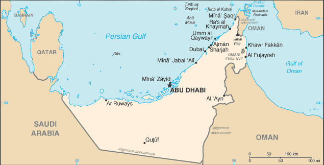
Which emirates make up the United Arab Emirates or UAE?
The United Arab Emirates, or UAE is a federation of seven states formed in 1971. These states were earlier ruled by Arab princes. Since then, it has grown from a quiet backwater into one of the Middle East's most important economic centres. Although each state - Abu Dhabi, Dubai, Ajman, Fujairah, Ras al Khaimah, Sharjah and Umm al Qaiwain - maintains a large degree of independence, the UAE is governed by a Supreme Council of rulers made up of the seven emirs, who appoint the prime minister and the cabinet. Before oil was discovered in the 1950's, the UAE's economy was dependent on fishing, and pearling industry. But since 1962, when Abu Dhabi became the first of the emirates to begin exporting oil, the country's society and economy have been transformed.Facts about United Arab Emirates
| Administrative divisions: | 7 emirates (imarat , singular - imarah); Abu Zaby (Abu Dhabi) , 'Ajman , Al Fujayrah , Ash Shariqah (Sharjah) , Dubayy (Dubai) , Ra's al Khaymah , Umm al Qaywayn (Quwayn) |
| Area: | total: 83 ,600 sq km land: 83 ,600 sq km water: 0 sq km |
| Background: | The Trucial States of the Persian Gulf coast granted the UK control of their defense and foreign affairs in 19th century treaties. In 1971 , six of these states - Abu Zaby , 'Ajman , Al Fujayrah , Ash Shariqah , Dubayy , and Umm al Qaywayn - merged to form the United Arab Emirates (UAE). They were joined in 1972 by Ra's al Khaymah. The UAE's per capita GDP is on par with those of leading West European nations. Its generosity with oil revenues and its moderate foreign policy stance have allowed the UAE to play a vital role in the affairs of the region. |
| Flag description: | three equal horizontal bands of green (top) , white , and black with a wider vertical red band on the hoist side |
| Capital: | name: Abu Dhabi geographic coordinates: 24 28 N , 54 22 E time difference: UTC+4 (9 hours ahead of Washington , DC during Standard Time) |
| Climate: | desert; cooler in eastern mountains |
| Currency code: | |
| Ethnic groups: | Emirati 19% , other Arab and Iranian 23% , South Asian 50% , other expatriates (includes Westerners and East Asians) 8% (1982) note: less than 20% are UAE citizens (1982) |
| Geographic coordinates: | 24 00 N , 54 00 E |
| Geography note: | strategic location along southern approaches to Strait of Hormuz , a vital transit point for world crude oil |
| Government type: | federation with specified powers delegated to the UAE federal government and other powers reserved to member emirates |
| Imports partners: | China 12.9% , India 10% , US 8.8% , Japan 6.1% , Germany 6% , UK 5.3% , Italy 4.6% (2007) |
| Internet country code: | .ae |
| Land boundaries: | 1 ,318 km |
| Neighbouring countries: | total: 867 km border countries: Oman 410 km , Saudi Arabia 457 km |
| Languages: | Arabic (official) , Persian , English , Hindi , Urdu |
| Location: | Middle East , bordering the Gulf of Oman and the Persian Gulf , between Oman and Saudi Arabia |
| Map references: | Middle East |
| National holiday: | Independence Day , 2 December (1971) |
| Nationality: | noun: Emirati(s) adjective: Emirati |
| Natural hazards: | frequent sand and dust storms |
| Population: | 4 ,621 ,399 note: estimate is based on the results of the 2005 census that included a significantly higher estimate of net inmigration of non-citizens than previous estimates (July 2008 est.) |
| Religions: | Muslim 96% (Shia 16%) , other (includes Christian , Hindu) 4% |
| Terrain: | flat , barren coastal plain merging into rolling sand dunes of vast desert wasteland; mountains in east |
| Unemployment rate: | 2.4% (2001) |
Capital of United Arab Emirates
Abū Z̧aby (click to view Abū Z̧aby map)
Places in United Arab Emirates
Browse the most comprehensive and up-to-date online directory of administrative regions and Street Views in United Arab Emirates. Our listings are organized alphabetically, starting from level 1 regions and progressing through to level 2 and eventually level 3 regions, ensuring you can easily navigate and find specific areas of interest.
Ajman Emirate (8 Google Maps locations)
Dubai Emirate (20 Google Maps locations)
Fujairah Emirate (69 Google Maps locations)
Sharjah Emirate (27 Google Maps locations)
Umm al-Quwain Emirate (8 Google Maps locations)
Random cities in United Arab Emirates
Abū Z̧aby, the capital city of United Arab Emirates.Al Fara`
Huwaylāt
Quţūf
Al Aţīr
Fashrah
Al Fay`
Ḩafīf
Al Quwayz
As Sūr
Al Manāmah
Sarūj
Rafā`
Ḩabḩab
Ar Rafā`ah
Minhā
Madḩah
Al Ḩajarayn
Biţnah
Ḩudaybah
Link to United Arab Emirates Google Maps page
The map of United Arab Emirates has already attracted 9668 views. If you wish to embed our comprehensive United Arab Emirates map on your site, we offer an easy solution. This map includes free access to Google Maps, gazetteer search, detailed country and city maps, Street View, and essential facts, all ready to enhance your website. To use it, simply copy and paste the provided HTML code into your webpage's source code. We appreciate every link back to our Maps and Driving Directions. Thank you for your support!
| Text link to: United Arab Emirates map and facts page |
This United Arab Emirates map is intended solely for informational purposes. No representations or warranties are made concerning its accuracy or reliability. Users assume all risks associated with the use of Google Maps and Google Driving Directions. World Route Planner is not liable for any losses or delays that may occur from using this free United Arab Emirates map.