 Republic of Finland Google Maps and Facts
Welcome to the Google Maps of Finland (FI) and the comprehensive location list for this country. World Route Planner, together with its detailed Finland page, turns Google Maps Sightseeing into a meaningful experience! Our extensive destination gazetteer, coupled with Driving Directions to Finland, allows you to explore Finland through detailed satellite imagery and street views—fast, free, and easier than ever before.
Browse through the list of administrative regions in Finland, navigate through these regions to find a place of interest, and book your hotel with the Best Price Guarantee! Your journey through Finland via Google Satellite Map Sightseeing and Street View starts here.
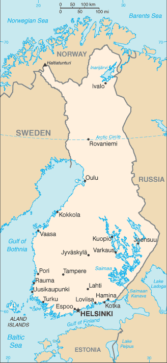
Finland Google Maps
To activate Street View on any city of Finland, drag above the Zoom feature the yellow little man in the map.
Facts about Finland
| Administrative divisions: | 6 provinces (laanit , singular - laani); Aland , Etela-Suomen Laani (Southern Finland) , Ita-Suomen Laani (Eastern Finland) , Lansi-Suomen Laani (Western Finland) , Lappi (Lapland) , Oulun Laani |
| Area: | total: 338 ,145 sq km land: 304 ,473 sq km water: 33 ,672 sq km |
| Background: | Finland was a province and then a grand duchy under Sweden from the 12th to the 19th centuries , and an autonomous grand duchy of Russia after 1809. It won its complete independence in 1917. During World War II , it was able to successfully defend its freedom and resist invasions by the Soviet Union - albeit with some loss of territory. In the subsequent half century , the Finns made a remarkable transformation from a farm/forest economy to a diversified modern industrial economy; per capita income is now among the highest in Western Europe. A member of the European Union since 1995 , Finland was the only Nordic state to join the euro system at its initiation in January 1999. |
| Flag description: | white with a blue cross extending to the edges of the flag; the vertical part of the cross is shifted to the hoist side in the style of the Dannebrog (Danish flag) |
| Capital: | name: Helsinki geographic coordinates: 60 10 N , 24 56 E time difference: UTC+2 (7 hours ahead of Washington , DC during Standard Time) daylight saving time: +1hr , begins last Sunday in March; ends last Sunday in October |
| Climate: | cold temperate; potentially subarctic but comparatively mild because of moderating influence of the North Atlantic Current , Baltic Sea , and more than 60 ,000 lakes |
| Currency code: | euro (EUR) |
| Ethnic groups: | Finn 93.4% , Swede 5.6% , Russian 0.5% , Estonian 0.3% , Roma (Gypsy) 0.1% , Sami 0.1% (2006) |
| Geographic coordinates: | 64 00 N , 26 00 E |
| Geography note: | long boundary with Russia; Helsinki is northernmost national capital on European continent; population concentrated on small southwestern coastal plain |
| Government type: | republic |
| Imports partners: | Germany 15.8% , Russia 14% , Sweden 13.7% , Netherlands 6.8% , China 5.5% , UK 4.9% (2007) |
| Internet country code: | .fi; note - Aland Islands assigned .ax |
| Land boundaries: | 1 ,250 km |
| Neighbouring countries: | total: 2 ,654 km border countries: Norway 727 km , Sweden 614 km , Russia 1 ,313 km |
| Languages: | Finnish 91.5% (official) , Swedish 5.5% (official) , other 3% (small Sami- and Russian-speaking minorities) (2006) |
| Location: | Northern Europe , bordering the Baltic Sea , Gulf of Bothnia , and Gulf of Finland , between Sweden and Russia |
| Map references: | Europe |
| National holiday: | Independence Day , 6 December (1917) |
| Nationality: | noun: Finn(s) adjective: Finnish |
| Natural hazards: | NA |
| Population: | 5 ,244 ,749 (July 2008 est.) |
| Religions: | Lutheran Church of Finland 82.5% , Orthodox Church 1.1% , other Christian 1.1% , other 0.1% , none 15.1% (2006) |
| Terrain: | mostly low , flat to rolling plains interspersed with lakes and low hills |
| Unemployment rate: | 6.9% (2007 est.) |
Capital of Republic of Finland
Helsingfors (click to view Helsingfors map)
Places in Finland
Browse the most comprehensive and up-to-date online directory of administrative regions and Street Views in Finland. Our listings are organized alphabetically, starting from level 1 regions and progressing through to level 2 and eventually level 3 regions, ensuring you can easily navigate and find specific areas of interest.
Province of Eastern Finland (1910 google map locations)
Province of Lapland (595 google map locations)
Province of Southern Finland (2842 google map locations)
Province of Western Finland (4320 google map locations)
Random cities in Finland
Helsingfors, the capital city of Finland.Kitula
Kakkulainen
Tapionniemi
Leinonvaara
Korpimäki
Nauvo
Mehtätalo
Savero
Tuomala
Hongistonmäki
Kursu
Boxby
Sääkskoski
Huotarila
Kiiskilänniemi
Ahvio
Kiimajoki
Uro
Haimila
Link to Finland Google Maps page
The map of Finland has already attracted 5721 views. If you wish to embed our comprehensive Finland map on your site, we offer an easy solution. This map includes free access to Google Maps, gazetteer search, detailed country and city maps, Street View, and essential facts, all ready to enhance your website. To use it, simply copy and paste the provided HTML code into your webpage's source code. We appreciate every link back to our Maps and Driving Directions. Thank you for your support!
| Text link to: Finland map and facts page |
This Finland map is intended solely for informational purposes. No representations or warranties are made concerning its accuracy or reliability. Users assume all risks associated with the use of Google Maps and Google Driving Directions. World Route Planner is not liable for any losses or delays that may occur from using this free Finland map.