 Kingdom of Sweden Google Maps and Facts
Welcome to the Google Maps of Sweden (SE) and the comprehensive location list for this country. World Route Planner, together with its detailed Sweden page, turns Google Maps Sightseeing into a meaningful experience! Our extensive destination gazetteer, coupled with Driving Directions to Sweden, allows you to explore Sweden through detailed satellite imagery and street views—fast, free, and easier than ever before.
Browse through the list of administrative regions in Sweden, navigate through these regions to find a place of interest, and book your hotel with the Best Price Guarantee! Your journey through Sweden via Google Satellite Map Sightseeing and Street View starts here.
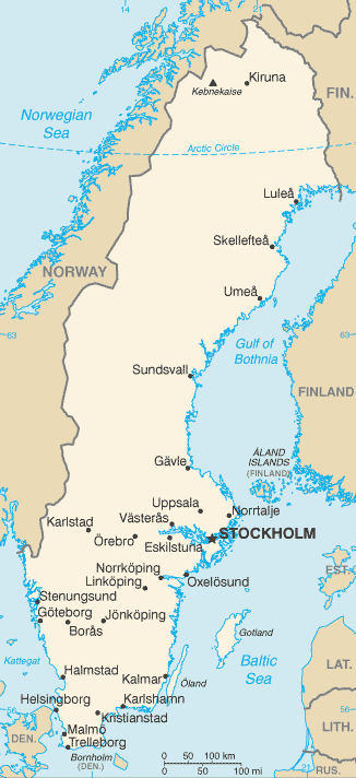
Sweden Google Maps
To activate Street View on any city of Sweden, drag above the Zoom feature the yellow little man in the map.
Facts about Sweden
| Administrative divisions: | 21 counties (lan , singular and plural); Blekinge , Dalarnas , Gavleborgs , Gotlands , Hallands , Jamtlands , Jonkopings , Kalmar , Kronobergs , Norrbottens , Orebro , Ostergotlands , Skane , Sodermanlands , Stockholm , Uppsala , Varmlands , Vasterbottens , Vasternorrlands , Vastmanlands , Vastra Gotalands |
| Area: | total: 449 ,964 sq km land: 410 ,934 sq km water: 39 ,030 sq km |
| Background: | A military power during the 17th century , Sweden has not participated in any war in almost two centuries. An armed neutrality was preserved in both World Wars. Sweden's long-successful economic formula of a capitalist system interlarded with substantial welfare elements was challenged in the 1990s by high unemployment and in 2000-02 by the global economic downturn , but fiscal discipline over the past several years has allowed the country to weather economic vagaries. Sweden joined the EU in 1995 , but the public rejected the introduction of the euro in a 2003 referendum. |
| Flag description: | blue with a golden yellow cross extending to the edges of the flag; the vertical part of the cross is shifted to the hoist side in the style of the Dannebrog (Danish flag) |
| Capital: | name: Stockholm geographic coordinates: 59 20 N , 18 03 E time difference: UTC+1 (6 hours ahead of Washington , DC during Standard Time) daylight saving time: +1hr , begins last Sunday in March; ends last Sunday in October |
| Climate: | temperate in south with cold , cloudy winters and cool , partly cloudy summers; subarctic in north |
| Currency code: | |
| Ethnic groups: | indigenous population: Swedes with Finnish and Sami minorities; foreign-born or first-generation immigrants: Finns , Yugoslavs , Danes , Norwegians , Greeks , Turks |
| Geographic coordinates: | 62 00 N , 15 00 E |
| Geography note: | strategic location along Danish Straits linking Baltic and North Seas |
| Government type: | constitutional monarchy |
| Imports partners: | Germany 18.4% , Denmark 9.2% , Norway 8.3% , UK 6.8% , Finland 6.1% , Netherlands 5.8% , France 5% , China 4.3% , Belgium 4.1% (2007) |
| Internet country code: | .se |
| Land boundaries: | 3 ,218 km |
| Neighbouring countries: | total: 2 ,233 km border countries: Finland 614 km , Norway 1 ,619 km |
| Languages: | Swedish , small Sami- and Finnish-speaking minorities |
| Location: | Northern Europe , bordering the Baltic Sea , Gulf of Bothnia , Kattegat , and Skagerrak , between Finland and Norway |
| Map references: | Europe |
| National holiday: | Swedish Flag Day , 6 June (1916); National Day , 6 June (1983) |
| Nationality: | noun: Swede(s) adjective: Swedish |
| Natural hazards: | ice floes in the surrounding waters , especially in the Gulf of Bothnia , can interfere with maritime traffic |
| Population: | 9 ,045 ,389 (July 2008 est.) |
| Religions: | Lutheran 87% , other (includes Roman Catholic , Orthodox , Baptist , Muslim , Jewish , and Buddhist) 13% |
| Terrain: | mostly flat or gently rolling lowlands; mountains in west |
| Unemployment rate: | 6.1% (2007 est.) |
Capital of Kingdom of Sweden
Stockholm (click to view Stockholm map)
Places in Sweden
Browse the most comprehensive and up-to-date online directory of administrative regions and Street Views in Sweden. Our listings are organized alphabetically, starting from level 1 regions and progressing through to level 2 and eventually level 3 regions, ensuring you can easily navigate and find specific areas of interest.
Dalarna County (1591 Google Maps locations)
Gävleborg County (1062 Google Maps locations)
Gotland County (113 Google Maps locations)
Halland County (840 Google Maps locations)
Jämtland County (1197 Google Maps locations)
Jönköping County (1147 Google Maps locations)
Kalmar County (1671 Google Maps locations)
Kronoberg County (1043 Google Maps locations)
Norrbotten County (984 Google Maps locations)
Örebro County (887 Google Maps locations)
Skåne County (1506 Google Maps locations)
Södermanland County (475 Google Maps locations)
Stockholm County (1215 Google Maps locations)
Uppsala County (807 Google Maps locations)
Värmland County (1454 Google Maps locations)
Västerbotten County (1348 Google Maps locations)
Västernorrland County (1355 Google Maps locations)
Västmanland County (679 Google Maps locations)
Västra Götaland County (2869 Google Maps locations)
Random cities in Sweden
Stockholm, the capital city of Sweden.Skälevik
Bornåsjösätern
Älva
Västra Eknö
Oxlehall
Grytinge
Smedsbo
Gillberga
Flatholmen
Tackerud
Töllstorp
Mem
Råamåla
Vittaryd
Håbo-Tibble
Nyby
Målerås
Eklunden
Lia
Link to Sweden Google Maps page
The map of Sweden has already attracted 11753 views. If you wish to embed our comprehensive Sweden map on your site, we offer an easy solution. This map includes free access to Google Maps, gazetteer search, detailed country and city maps, Street View, and essential facts, all ready to enhance your website. To use it, simply copy and paste the provided HTML code into your webpage's source code. We appreciate every link back to our Maps and Driving Directions. Thank you for your support!
| Text link to: Sweden map and facts page |
This Sweden map is intended solely for informational purposes. No representations or warranties are made concerning its accuracy or reliability. Users assume all risks associated with the use of Google Maps and Google Driving Directions. World Route Planner is not liable for any losses or delays that may occur from using this free Sweden map.