 Slovak Republic Google Maps and Facts
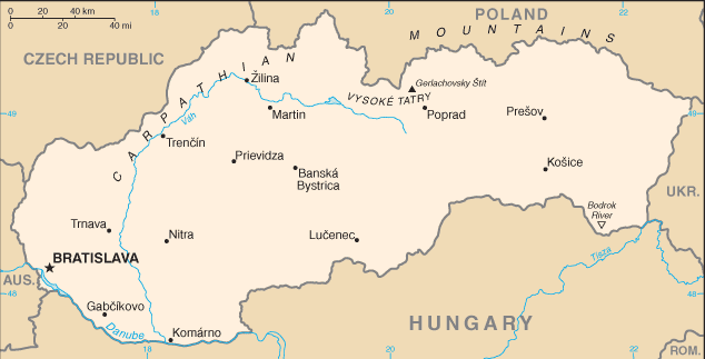
Welcome to the Google Maps of Slovakia (SK) and the comprehensive location list for this country. World Route Planner, together with its detailed Slovakia page, turns Google Maps Sightseeing into a meaningful experience! Our extensive destination gazetteer, coupled with Driving Directions to Slovakia, allows you to explore Slovakia through detailed satellite imagery and street views—fast, free, and easier than ever before.
Browse through the list of administrative regions in Slovakia, navigate through these regions to find a place of interest, and book your hotel with the Best Price Guarantee! Your journey through Slovakia via Google Satellite Map Sightseeing and Street View starts here.
Slovakia Google Maps
To activate Street View on any city of Slovakia, drag above the Zoom feature the yellow little man in the map.
Facts about Slovakia
| Administrative divisions: | 8 regions (kraje , singular - kraj); Banskobystricky , Bratislavsky , Kosicky , Nitriansky , Presovsky , Trenciansky , Trnavsky , Zilinsky |
| Area: | total: 48 ,845 sq km land: 48 ,800 sq km water: 45 sq km |
| Background: | The dissolution of the Austro-Hungarian Empire at the close of World War I allowed the Slovaks to join the closely related Czechs to form Czechoslovakia. Following the chaos of World War II , Czechoslovakia became a Communist nation within Soviet-dominated Eastern Europe. Soviet influence collapsed in 1989 and Czechoslovakia once more became free. The Slovaks and the Czechs agreed to separate peacefully on 1 January 1993. Slovakia joined both NATO and the EU in the spring of 2004. |
| Flag description: | three equal horizontal bands of white (top) , blue , and red superimposed with the coat of arms of Slovakia (consisting of a red shield bordered in white and bearing a white Cross of Lorraine surmounting three blue hills); the coat of arms is centered vertically and offset slightly to the hoist side |
| Capital: | name: Bratislava geographic coordinates: 48 09 N , 17 07 E time difference: UTC+1 (6 hours ahead of Washington , DC during Standard Time) daylight saving time: +1hr , begins last Sunday in March; ends last Sunday in October |
| Climate: | temperate; cool summers; cold , cloudy , humid winters |
| Currency code: | |
| Ethnic groups: | Slovak 85.8% , Hungarian 9.7% , Roma 1.7% , Ruthenian/Ukrainian 1% , other and unspecified 1.8% (2001 census) |
| Geographic coordinates: | 48 40 N , 19 30 E |
| Geography note: | landlocked; most of the country is rugged and mountainous; the Tatra Mountains in the north are interspersed with many scenic lakes and valleys |
| Government type: | parliamentary democracy |
| Imports partners: | Germany 22.1% , Czech Republic 17.3% , Russia 9.2% , Hungary 6.7% , Austria 5.1% , Poland 4.9% , South Korea 4.7% (2007) |
| Internet country code: | .sk |
| Land boundaries: | 0 km (landlocked) |
| Neighbouring countries: | total: 1 ,474 km border countries: Austria 91 km , Czech Republic 197 km , Hungary 676 km , Poland 420 km , Ukraine 90 km |
| Languages: | Slovak (official) 83.9% , Hungarian 10.7% , Roma 1.8% , Ukrainian 1% , other or unspecified 2.6% (2001 census) |
| Location: | Central Europe , south of Poland |
| Map references: | Europe |
| National holiday: | Constitution Day , 1 September (1992) |
| Nationality: | noun: Slovak(s) adjective: Slovak |
| Natural hazards: | NA |
| Population: | 5 ,455 ,407 (July 2008 est.) |
| Religions: | Roman Catholic 68.9% , Protestant 10.8% , Greek Catholic 4.1% , other or unspecified 3.2% , none 13% (2001 census) |
| Terrain: | rugged mountains in the central and northern part and lowlands in the south |
| Unemployment rate: | 8.4% (2007 est.) |
Capital of Slovak Republic
Bratislava (click to view Bratislava map)
Places in Slovakia
Browse the most comprehensive and up-to-date online directory of administrative regions and Street Views in Slovakia. Our listings are organized alphabetically, starting from level 1 regions and progressing through to level 2 and eventually level 3 regions, ensuring you can easily navigate and find specific areas of interest.
Bobrovník city Google Maps
Bratislavský Kraj (138 Google Maps locations)
Košický Kraj (592 Google Maps locations)
Nitriansky Kraj (665 Google Maps locations)
Trenčiansky Kraj (606 Google Maps locations)
Trnavský Kraj (429 Google Maps locations)
Zilina County (660 Google Maps locations)
Random cities in Slovakia
Bratislava, the capital city of Slovakia.Bucsi Majer
Poloma
Zlatníky
Horňákova Kopanica
Dolné Motešice
Mihályháza
Zálubie
Nový Dvor
Tuhrina
Kopčany
Záhradné
Drgonova Dolina
Vlková
Studienka
Ostrovany
Magale
Bunetice
Šarišská Poruba
Jablonov
Link to Slovakia Google Maps page
The map of Slovakia has already attracted 4481 views. If you wish to embed our comprehensive Slovakia map on your site, we offer an easy solution. This map includes free access to Google Maps, gazetteer search, detailed country and city maps, Street View, and essential facts, all ready to enhance your website. To use it, simply copy and paste the provided HTML code into your webpage's source code. We appreciate every link back to our Maps and Driving Directions. Thank you for your support!
| Text link to: Slovakia map and facts page |
This Slovakia map is intended solely for informational purposes. No representations or warranties are made concerning its accuracy or reliability. Users assume all risks associated with the use of Google Maps and Google Driving Directions. World Route Planner is not liable for any losses or delays that may occur from using this free Slovakia map.