 Kingdom of Denmark Google Maps and Facts
Welcome to the Google Maps of Denmark (DK) and the comprehensive location list for this country. World Route Planner, together with its detailed Denmark page, turns Google Maps Sightseeing into a meaningful experience! Our extensive destination gazetteer, coupled with Driving Directions to Denmark, allows you to explore Denmark through detailed satellite imagery and street views—fast, free, and easier than ever before.
Browse through the list of administrative regions in Denmark, navigate through these regions to find a place of interest, and book your hotel with the Best Price Guarantee! Your journey through Denmark via Google Satellite Map Sightseeing and Street View starts here.
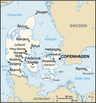
Denmark Google Maps
To activate Street View on any city of Denmark, drag above the Zoom feature the yellow little man in the map.
Facts about Denmark
| Administrative divisions: | metropolitan Denmark - 5 regions (regioner , singular - region); Hovedstaden , Midtjylland , Nordjylland , Sjaelland , Syddanmark note: an extensive local government reform merged 271 municipalities into 98 and 13 counties into five regions , effective 1 January 2007 |
| Area: | total: 43 ,094 sq km land: 42 ,394 sq km water: 700 sq km note: includes the island of Bornholm in the Baltic Sea and the rest of metropolitan Denmark (the Jutland Peninsula , and the major islands of Sjaelland and Fyn) , but excludes the Faroe Islands and Greenland Dhekelia |
| Background: | Once the seat of Viking raiders and later a major north European power , Denmark has evolved into a modern , prosperous nation that is participating in the general political and economic integration of Europe. It joined NATO in 1949 and the EEC (now the EU) in 1973. However , the country has opted out of certain elements of the European Union's Maastricht Treaty , including the European Economic and Monetary Union (EMU) , European defense cooperation , and issues concerning certain justice and home affairs. Dhekelia |
| Flag description: | red with a white cross that extends to the edges of the flag; the vertical part of the cross is shifted to the hoist side; the banner is referred to as the Dannebrog (Danish flag) note: the shifted design element was subsequently adopted by the other Nordic countries of Finland , Iceland , Norway , and Sweden Dhekelia |
| Capital: | name: Copenhagen geographic coordinates: 55 40 N , 12 35 E time difference: UTC+1 (6 hours ahead of Washington , DC during Standard Time) daylight saving time: +1hr , begins last Sunday in March; ends last Sunday in October note: applies to continental Denmark only , not to the North Atlantic components Dhekelia |
| Climate: | temperate; humid and overcast; mild , windy winters and cool summers Dhekelia |
| Currency code: | Danish krone (DKK) Dhekelia |
| Ethnic groups: | Scandinavian , Inuit , Faroese , German , Turkish , Iranian , Somali |
| Geographic coordinates: | 56 00 N , 10 00 E Dhekelia |
| Geography note: | controls Danish Straits (Skagerrak and Kattegat) linking Baltic and North Seas; about one-quarter of the population lives in greater Copenhagen Dhekelia |
| Government type: | constitutional monarchy |
| Imports partners: | Germany 21.7% , Sweden 14.4% , Netherlands 7.1% , Norway 6% , China 5.3% , UK 5.2% , Italy 4.1% , France 4% (2007) |
| Internet country code: | .dk |
| Land boundaries: | 7 ,314 km Dhekelia |
| Neighbouring countries: | total: 68 km border countries: Germany 68 km Dhekelia |
| Languages: | Danish , Faroese , Greenlandic (an Inuit dialect) , German (small minority) note: English is the predominant second language Dhekelia |
| Location: | Northern Europe , bordering the Baltic Sea and the North Sea , on a peninsula north of Germany (Jutland); also includes two major islands (Sjaelland and Fyn) Dhekelia |
| Map references: | Europe Dhekelia |
| National holiday: | none designated; Constitution Day , 5 June (1849) is generally viewed as the National Day |
| Nationality: | noun: Dane(s) adjective: Danish |
| Natural hazards: | flooding is a threat in some areas of the country (e.g. , parts of Jutland , along the southern coast of the island of Lolland) that are protected from the sea by a system of dikes |
| Population: | 5 ,484 ,723 (July 2008 est.) Dhekelia |
| Religions: | Evangelical Lutheran 95% , other Christian (includes Protestant and Roman Catholic) 3% , Muslim 2% |
| Terrain: | low and flat to gently rolling plains |
| Unemployment rate: | 2.8% (2007 est.) |
Capital of Kingdom of Denmark
København (click to view København map)
Places in Denmark
Browse the most comprehensive and up-to-date online directory of administrative regions and Street Views in Denmark. Our listings are organized alphabetically, starting from level 1 regions and progressing through to level 2 and eventually level 3 regions, ensuring you can easily navigate and find specific areas of interest.
Region Central Jutland (1665 Google Maps locations)
Region Northern Jutland (1017 Google Maps locations)
Random cities in Denmark
København, the capital city of Denmark.Gødvad
Fræer
Søllerup
Testrup
Sønder Omme
Ølby
Stavshede
Kvolbæk
Åle
Fuglebækshuse
Måde
Favrskov Mark
Augustenhof
Torup
Tyrstrup
Askildrup
Hjallerup
Størlinge
Arløse Torp
Link to Denmark Google Maps page
The map of Denmark has already attracted 20281 views. If you wish to embed our comprehensive Denmark map on your site, we offer an easy solution. This map includes free access to Google Maps, gazetteer search, detailed country and city maps, Street View, and essential facts, all ready to enhance your website. To use it, simply copy and paste the provided HTML code into your webpage's source code. We appreciate every link back to our Maps and Driving Directions. Thank you for your support!
| Text link to: Denmark map and facts page |
This Denmark map is intended solely for informational purposes. No representations or warranties are made concerning its accuracy or reliability. Users assume all risks associated with the use of Google Maps and Google Driving Directions. World Route Planner is not liable for any losses or delays that may occur from using this free Denmark map.