 Republic of Croatia Google Maps and Facts
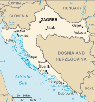
Welcome to the Google Maps of Croatia (HR) and the comprehensive location list for this country. World Route Planner, together with its detailed Croatia page, turns Google Maps Sightseeing into a meaningful experience! Our extensive destination gazetteer, coupled with Driving Directions to Croatia, allows you to explore Croatia through detailed satellite imagery and street views—fast, free, and easier than ever before.
Browse through the list of administrative regions in Croatia, navigate through these regions to find a place of interest, and book your hotel with the Best Price Guarantee! Your journey through Croatia via Google Satellite Map Sightseeing and Street View starts here.
Croatia Google Maps
To activate Street View on any city of Croatia, drag above the Zoom feature the yellow little man in the map.
Facts about Croatia
| Administrative divisions: | 20 counties (zupanije , zupanija - singular) and 1 city* (grad - singular); Bjelovarsko-Bilogorska , Brodsko-Posavska , Dubrovacko-Neretvanska (Dubrovnik-Neretva) , Istarska (Istria) , Karlovacka , Koprivnicko-Krizevacka , Krapinsko-Zagorska , Licko-Senjska (Lika-Senj) , Medimurska , Osjecko-Baranjska , Pozesko-Slavonska (Pozega-Slavonia) , Primorsko-Goranska , Sibensko-Kninska , Sisacko-Moslavacka , Splitsko-Dalmatinska (Split-Dalmatia) , Varazdinska , Viroviticko-Podravska , Vukovarsko-Srijemska , Zadarska , Zagreb* , Zagrebacka |
| Area: | total: 56 ,542 sq km land: 56 ,414 sq km water: 128 sq km |
| Background: | The lands that today comprise Croatia were part of the Austro-Hungarian Empire until the close of World War I. In 1918 , the Croats , Serbs , and Slovenes formed a kingdom known after 1929 as Yugoslavia. Following World War II , Yugoslavia became a federal independent Communist state under the strong hand of Marshal TITO. Although Croatia declared its independence from Yugoslavia in 1991 , it took four years of sporadic , but often bitter , fighting before occupying Serb armies were mostly cleared from Croatian lands. Under UN supervision , the last Serb-held enclave in eastern Slavonia was returned to Croatia in 1998. |
| Flag description: | three equal horizontal bands of red (top) , white , and blue superimposed by the Croatian coat of arms (red and white checkered) |
| Capital: | name: Zagreb geographic coordinates: 45 48 N , 16 00 E time difference: UTC+1 (6 hours ahead of Washington , DC during Standard Time) daylight saving time: +1hr , begins last Sunday in March; ends last Sunday in October |
| Climate: | Mediterranean and continental; continental climate predominant with hot summers and cold winters; mild winters , dry summers along coast |
| Currency code: | kuna (HRK) |
| Ethnic groups: | Croat 89.6% , Serb 4.5% , other 5.9% (including Bosniak , Hungarian , Slovene , Czech , and Roma) (2001 census) |
| Geographic coordinates: | 45 10 N , 15 30 E |
| Geography note: | controls most land routes from Western Europe to Aegean Sea and Turkish Straits; most Adriatic Sea islands lie off the coast of Croatia - some 1 ,200 islands , islets , ridges , and rocks |
| Government type: | presidential/parliamentary democracy |
| Imports partners: | Italy 16.1% , Germany 14.4% , Russia 10.1% , China 6.2% , Slovenia 6% , Austria 5.3% (2007) |
| Internet country code: | .hr |
| Land boundaries: | 5 ,835 km (mainland 1 ,777 km , islands 4 ,058 km) |
| Neighbouring countries: | total: 1 ,982 km border countries: Bosnia and Herzegovina 932 km , Hungary 329 km , Serbia 241 km , Montenegro 25 km , Slovenia 455 km |
| Languages: | Croatian 96.1% , Serbian 1% , other and undesignated 2.9% (including Italian , Hungarian , Czech , Slovak , and German) (2001 census) |
| Location: | Southeastern Europe , bordering the Adriatic Sea , between Bosnia and Herzegovina and Slovenia |
| Map references: | Europe |
| National holiday: | Independence Day , 8 October (1991); note - 25 June 1991 was the day the Croatian Parliament voted for independence; following a three-month moratorium to allow the European Community to solve the Yugoslav crisis peacefully , Parliament adopted a decision on 8 October 1991 to sever constitutional relations with Yugoslavia |
| Nationality: | noun: Croat(s) , Croatian(s) adjective: Croatian |
| Natural hazards: | destructive earthquakes |
| Population: | 4 ,491 ,543 (July 2008 est.) |
| Religions: | Roman Catholic 87.8% , Orthodox 4.4% , other Christian 0.4% , Muslim 1.3% , other and unspecified 0.9% , none 5.2% (2001 census) |
| Terrain: | geographically diverse; flat plains along Hungarian border , low mountains and highlands near Adriatic coastline and islands |
| Unemployment rate: | 11.8% (2007 est.) |
Capital of Republic of Croatia
Zagreb (click to view Zagreb map)
Places in Croatia
Browse the most comprehensive and up-to-date online directory of administrative regions and Street Views in Croatia. Our listings are organized alphabetically, starting from level 1 regions and progressing through to level 2 and eventually level 3 regions, ensuring you can easily navigate and find specific areas of interest.
Brodsko-Posavska Županija (210 Google Maps locations)
Dubrovačko-Neretvanska Županija (544 Google Maps locations)
Grad Zagreb (95 Google Maps locations)
Istarska Županija (455 Google Maps locations)
Karlovačka Županija (514 Google Maps locations)
Koprivničko-Križevačka Županija (175 Google Maps locations)
Krapinsko-Zagorska Županija (146 Google Maps locations)
Ličko-Senjska Županija (888 Google Maps locations)
Međimurska Županija (91 Google Maps locations)
Osječko-Baranjska Županija (309 Google Maps locations)
Primorsko-Goranska Županija (331 Google Maps locations)
Šibensko-Kninska Županija (289 Google Maps locations)
Sisačko-Moslavačka Županija (620 Google Maps locations)
Splitsko-Dalmatinska Županija (1295 Google Maps locations)
Varaždinska Županija (165 Google Maps locations)
Virovitičko-Podravska Županija (167 Google Maps locations)
Vukovarsko-Srijemska Županija (128 Google Maps locations)
Zadarska Županija (351 Google Maps locations)
Zagrebačka Županija (428 Google Maps locations)
Random cities in Croatia
Zagreb, the capital city of Croatia.Kolarovec
Brašina
Macinec
Slivno
Mirkovići
Golubić
Dajla
Ðurići
Drage
Sušanj
Medakovići
Ljubičići
Saborsko
Martinski
Predore
Kupjak
Rujići
Laslovo
Blečići
Link to Croatia Google Maps page
The map of Croatia has already attracted 7078 views. If you wish to embed our comprehensive Croatia map on your site, we offer an easy solution. This map includes free access to Google Maps, gazetteer search, detailed country and city maps, Street View, and essential facts, all ready to enhance your website. To use it, simply copy and paste the provided HTML code into your webpage's source code. We appreciate every link back to our Maps and Driving Directions. Thank you for your support!
| Text link to: Croatia map and facts page |
This Croatia map is intended solely for informational purposes. No representations or warranties are made concerning its accuracy or reliability. Users assume all risks associated with the use of Google Maps and Google Driving Directions. World Route Planner is not liable for any losses or delays that may occur from using this free Croatia map.